
Since I've been studying genealogy, I've become acutely aware of how tenuous a thing it is for a family name to survive from generation to generation. In earlier times everyone had large families, what with child mortality from sanitary conditions and epidemics being so high. Lots of kids helped insure that at least one boy would survive in each generation to carry on the family name.
My great great great grandfather, Joseph Burton, had five sons: James, John, Henry, William, and Thomas. Of these five, Henry and William had no children, and John had only a single girl child. Only James and the youngest son, Thomas, my great great grandfather, had boys.
James had three sons: Frederick in 1851, Thomas in 1858, and Henry in 1862.
Thomas had two sons: Joseph in 1850 and Albin in 1868
I looked up James' son Thomas and found that he was still living in Wiltshire in 1901, as was his brother, Henry. Frederick had moved to Andover, Hampshire, but was also still in England by the time of the 1901 census. I suspect none of these brothers immigrated to America.
Turning to Thomas, my gg-grandfather's sons, Joseph and Albin, we find that Albin, the younger son, was still living in England in 1901. Older brother, Joseph was the only Burton boy to immigrate to America, which he did in late 1879 or early 1880 after having a son, Thomas, in 1879. It was in America, in the state of Pennsylvania, that my Grandmother, Gwendolain Burton, was born around 1887. While not important for survival of the Burton name, it sure was an important event for me.
It will be interesting to research further to find out if Joseph's son, Thomas (or a later son, Alexander) produced sons to carry on the Burton name in America. In England, the descendants of James' sons, Thomas and Frederick (son Henry evidently had no children), whose names were Ashton, Edwin, Frederick, Henry, and Arthur, almost certainly produced a son between the five of them, and Thomas' son, Albin had two boys, Reginald and George, who could have produced a boy or two between them. If so, my Burton ancestors in Wiltshire and Hampshire probably number in the dozens, if not hundreds. Maybe I'll run into one or two on our upcoming trip.
Showing posts with label Wiltshire. Show all posts
Showing posts with label Wiltshire. Show all posts
Thursday, July 24, 2008

Wednesday, July 23, 2008
More on Tisbury, Wiltshire, England
Here's a bit more history on the village of Tisbury, Wiltshire, that I gleaned from a Wiltshire government site:
"Tisbury is slightly unusual for a large Wiltshire parish, with early settlement, in that no main road crosses the parish, and no road in it was turnpiked. The only road through the village is that from Chilmark to Fovant, which is joined by a minor road from the west at Tisbury. Historically the modern civil parishes of West Tisbury and East Tisbury were one and much of the early history below relates to this whole area, which includes Wardour and Hatch. The later history, and histories of churches and schools, is concerned only with the modern parish of Tisbury, formerly East Tisbury, which contains the nucleated village and Wardour.
 The first known settlement of the village site of Tisbury came in Saxon times. This was probably a defensive site, the name indicates this, and it is possible that it was part of King Alfred’s Burghal Hidage, providing one of the fortresses prepared for defence against the Danes. Tisbury was certainly occupied by the West Saxons who, by 759, named it Tissebiri – Tysse’s Burh. A monastery was here by 700 and may have been established by 674. An early, if not the first, abbot was Wintra who is mentioned in land documents. In 705 the Synod of the Nadder was held here, which was attended by a young monk named Winfrith, who is better known, particularly in continental Europe, as St. Boniface. The fact that Tisbury hosted this synod is a good indication as to the importance of the monastery here. The monastery was probably one large building, with a separate church and outbuildings. It was razed to the ground in the 19th century during the early Norse raids and the monks were slain.
When King Alfred founded Shaftesbury Abbey, c.880, the lands of Tisbury were given to the Abbey. It is at this time that the village is first mentioned although it is likely to have already existed for 150-200 years. It is most likely that the village had a stone church, probably on the site of the present one. In 984 King Ethelred confirmed the grant of the Tisbury estate to the Abbess of Shaftesbury. The grange, or administrative headquarters, of the estate was at Place Farm, where the medieval buildings of Shaftesbury’s farming operations can still be seen.
By the time of the Norman Conquest Tisbury was a reasonable sized village and the Domesday Book (1086) gives us some idea of this although the population is for the whole estate, not just the village. Using modern interpretation of Domesday figures it would seem that over 300 people lived on the estate and interestingly there were no serfs listed. The village itself is likely to have been in the lower part of the present High Street and around the church. There was a Saxon routeway between Ebbesbourne Wake and Warminster and this was on solid bedrock in Tisbury and so did not deviate when bad weather caused deep mud elsewhere. The upper part of the High Street follows this line and so you may still walk where Saxon traders travelled. By the late 11th century there were four mills, meadowland, pastureland and woodland on the estate, which had land for 40 plough teams.
Cloth production is evidenced by mention of a fulling mill in the early 14th century and weavers are mentioned from 1372 to 1762. By 1334 this was a wealthy and populous parish, which including Hatch, was given the fifth highest assessment for wealth in the county. It seems that Tisbury suffered badly in the Black Death of 1348-9, which cut the population drastically and caused much land to remain uncultivated. It was especially bad in Hatch, in West Tisbury. In 1349 about 75 deaths of customary tenants, and doubtless their families, were recorded by Shaftesbury Abbey. However the village and estate seems to have recovered well as by 1377 there were 433 poll tax payers, making this one of the most populous parishes in the county.
During the 15th century the village had expanded. The main village street was the upper part of the High Street while North Street (Hindon Lane today) had houses and homesteads along it by 1444. Quarrying was still taking place throughout the parish and weaving was a local industry. By c.1500 all the arable land had been enclosed enabling more efficient farming to be carried out. This was part of a modernization program by Shaftesbury Abbey, whose grange at Place Farm had two larder houses, stables, houses for oxen, hay sheds, charcoal sheds and a fishpond within its walls, and the present great barn and three fish ponds without.
In 1825 a short lived industrial venture began with the building of a cloth factory at the southern end of Fonthill Lake. There was a 6-storey block, a 5-storey factory with 3 water wheels, a drying house and a dyehouse. The buildings were erected by the eccentric Mr Farquhar, a retired gunpowder maker, and completed by 1827 with a house and 24 cottages. The idea was to weave a superfine woollen cloth and 200 people, mainly from Gloucestershire, were employed. Despite an abundant supply of water the venture failed, probably as this was a remote area, with poor communications and a factory could not compete with the steam powered ones of western Wiltshire that were sited near canals. The machinery was sold in 1830 and the buildings demolished between 1838 and 1886.
Tisbury was divided into three parishes in 1835 – East Tisbury (Tisbury village), West Tisbury and Wardour. By 1846 there were 40 stone quarries, although not all were in use. They were mainly used for local buildings as, in the first part of the 19th century, Tisbury stone was expensive in London as there was no local canal or railway for transport. After the opening of the railway line the situation changed and there was a stone yard at the railway station in the latter part of the 19th century. The Salisbury and Yeovil Railway opened this line in 1859 and Tisbury Station was built to the south of the village. At first this was a single line, it was doubled by 1870 but in 1967 it was reduced to a single line across the parish again. After the coming of the railway Tisbury began to take on the appearance of a small town."
Thanks to Stefan Slatter and picturesofengland.com for the nice sunset photo of Tisbury.
"Tisbury is slightly unusual for a large Wiltshire parish, with early settlement, in that no main road crosses the parish, and no road in it was turnpiked. The only road through the village is that from Chilmark to Fovant, which is joined by a minor road from the west at Tisbury. Historically the modern civil parishes of West Tisbury and East Tisbury were one and much of the early history below relates to this whole area, which includes Wardour and Hatch. The later history, and histories of churches and schools, is concerned only with the modern parish of Tisbury, formerly East Tisbury, which contains the nucleated village and Wardour.
 The first known settlement of the village site of Tisbury came in Saxon times. This was probably a defensive site, the name indicates this, and it is possible that it was part of King Alfred’s Burghal Hidage, providing one of the fortresses prepared for defence against the Danes. Tisbury was certainly occupied by the West Saxons who, by 759, named it Tissebiri – Tysse’s Burh. A monastery was here by 700 and may have been established by 674. An early, if not the first, abbot was Wintra who is mentioned in land documents. In 705 the Synod of the Nadder was held here, which was attended by a young monk named Winfrith, who is better known, particularly in continental Europe, as St. Boniface. The fact that Tisbury hosted this synod is a good indication as to the importance of the monastery here. The monastery was probably one large building, with a separate church and outbuildings. It was razed to the ground in the 19th century during the early Norse raids and the monks were slain.
When King Alfred founded Shaftesbury Abbey, c.880, the lands of Tisbury were given to the Abbey. It is at this time that the village is first mentioned although it is likely to have already existed for 150-200 years. It is most likely that the village had a stone church, probably on the site of the present one. In 984 King Ethelred confirmed the grant of the Tisbury estate to the Abbess of Shaftesbury. The grange, or administrative headquarters, of the estate was at Place Farm, where the medieval buildings of Shaftesbury’s farming operations can still be seen.
By the time of the Norman Conquest Tisbury was a reasonable sized village and the Domesday Book (1086) gives us some idea of this although the population is for the whole estate, not just the village. Using modern interpretation of Domesday figures it would seem that over 300 people lived on the estate and interestingly there were no serfs listed. The village itself is likely to have been in the lower part of the present High Street and around the church. There was a Saxon routeway between Ebbesbourne Wake and Warminster and this was on solid bedrock in Tisbury and so did not deviate when bad weather caused deep mud elsewhere. The upper part of the High Street follows this line and so you may still walk where Saxon traders travelled. By the late 11th century there were four mills, meadowland, pastureland and woodland on the estate, which had land for 40 plough teams.
Cloth production is evidenced by mention of a fulling mill in the early 14th century and weavers are mentioned from 1372 to 1762. By 1334 this was a wealthy and populous parish, which including Hatch, was given the fifth highest assessment for wealth in the county. It seems that Tisbury suffered badly in the Black Death of 1348-9, which cut the population drastically and caused much land to remain uncultivated. It was especially bad in Hatch, in West Tisbury. In 1349 about 75 deaths of customary tenants, and doubtless their families, were recorded by Shaftesbury Abbey. However the village and estate seems to have recovered well as by 1377 there were 433 poll tax payers, making this one of the most populous parishes in the county.
During the 15th century the village had expanded. The main village street was the upper part of the High Street while North Street (Hindon Lane today) had houses and homesteads along it by 1444. Quarrying was still taking place throughout the parish and weaving was a local industry. By c.1500 all the arable land had been enclosed enabling more efficient farming to be carried out. This was part of a modernization program by Shaftesbury Abbey, whose grange at Place Farm had two larder houses, stables, houses for oxen, hay sheds, charcoal sheds and a fishpond within its walls, and the present great barn and three fish ponds without.
In 1825 a short lived industrial venture began with the building of a cloth factory at the southern end of Fonthill Lake. There was a 6-storey block, a 5-storey factory with 3 water wheels, a drying house and a dyehouse. The buildings were erected by the eccentric Mr Farquhar, a retired gunpowder maker, and completed by 1827 with a house and 24 cottages. The idea was to weave a superfine woollen cloth and 200 people, mainly from Gloucestershire, were employed. Despite an abundant supply of water the venture failed, probably as this was a remote area, with poor communications and a factory could not compete with the steam powered ones of western Wiltshire that were sited near canals. The machinery was sold in 1830 and the buildings demolished between 1838 and 1886.
Tisbury was divided into three parishes in 1835 – East Tisbury (Tisbury village), West Tisbury and Wardour. By 1846 there were 40 stone quarries, although not all were in use. They were mainly used for local buildings as, in the first part of the 19th century, Tisbury stone was expensive in London as there was no local canal or railway for transport. After the opening of the railway line the situation changed and there was a stone yard at the railway station in the latter part of the 19th century. The Salisbury and Yeovil Railway opened this line in 1859 and Tisbury Station was built to the south of the village. At first this was a single line, it was doubled by 1870 but in 1967 it was reduced to a single line across the parish again. After the coming of the railway Tisbury began to take on the appearance of a small town."
Thanks to Stefan Slatter and picturesofengland.com for the nice sunset photo of Tisbury.
Tisbury, Wiltshire, England
My Burton ancestors came, at least in the 19th century, from the tiny village of Tisbury, Wiltshire. I found a short history of Tisbury, which unfortunately doesn't mention my estemed ancestors, at the local historical society site:
BRIEF HISTORY OF TISBURY
Tisbury is the most prominent of the Nadder Valley villages. It is situated on the steep northern slopes of the valley underlaid by the light grey Portland stone used for the two Salisbury Cathedrals and many other local buildings. Quarrying, therefore, would have been an important local industry from very early times.
Because of the marshy nature of the river, the original inhabitants of the area may well have lived east of the Nadder at the hilltop fortification known as Castle Ditches. It was the Saxons who first descended to the valley sometime between the 6th and 8th Centuries to create a series of settlements one of which became known as Tysse’s Burgh, ‘the stronghold of Tysse’s people’. An Anglo-Saxon monastery of some importance also developed here and continued until the creation of King Alfred’s new abbey at Shaftesbury in the mid-880s.
By the late l2th Century, the little community along the Nadder had become sufficiently prosperous to replace its earlier wooden Saxon church with the prominent parish church of St John the Baptist. The requirements of an increasing population led to many changes resulting in the fine cruciform building we now see today. This included the raising of the roof in the mid-l5th Century to allow the new clerestory to flood the church with light. The earlier 60 foot spire, too, was discarded in l762 after lightning strikes had brought it tumbling into the north aisle for the second time in twenty years!
East of the church lie the graves of John Lockwood and Alice Kipling, the parents of the author Rudyard Kipling. After a long and distinguished artistic career in India, the Kiplings retired to a residence along Hindon Lane which they renamed ‘The Gables’. Their famous son visited them here and, whilst working on his novel ‘Kim’, used one of the pupils from Tisbury Boys’ School as the model for the main character.
The construction of the London to Exeter Railway in l859 transformed the tiny village of Tisbury, allowing it to develop a much larger commercial and light industrial base. But this would not have been possible without the foresight of the speculator, Archibald Beckett. He constructed a new road, the current High Street, through the village replacing the narrow causeway which can still be seen winding between houses to the east. Beckett also built the red brick Victorian shops and houses which fringe the road and an inn, the Benett Arms and finally the brewery in Church Street which has been converted into apartments. Beckett’s initiative was complemented by other new roads straddling the developing community and constructed by the Arundell and Morrison families from Wardour Castle and Fonthill Park. Thus arose the framework for the Tisbury we see today.
BRIEF HISTORY OF TISBURY
Tisbury is the most prominent of the Nadder Valley villages. It is situated on the steep northern slopes of the valley underlaid by the light grey Portland stone used for the two Salisbury Cathedrals and many other local buildings. Quarrying, therefore, would have been an important local industry from very early times.
Because of the marshy nature of the river, the original inhabitants of the area may well have lived east of the Nadder at the hilltop fortification known as Castle Ditches. It was the Saxons who first descended to the valley sometime between the 6th and 8th Centuries to create a series of settlements one of which became known as Tysse’s Burgh, ‘the stronghold of Tysse’s people’. An Anglo-Saxon monastery of some importance also developed here and continued until the creation of King Alfred’s new abbey at Shaftesbury in the mid-880s.
By the late l2th Century, the little community along the Nadder had become sufficiently prosperous to replace its earlier wooden Saxon church with the prominent parish church of St John the Baptist. The requirements of an increasing population led to many changes resulting in the fine cruciform building we now see today. This included the raising of the roof in the mid-l5th Century to allow the new clerestory to flood the church with light. The earlier 60 foot spire, too, was discarded in l762 after lightning strikes had brought it tumbling into the north aisle for the second time in twenty years!
East of the church lie the graves of John Lockwood and Alice Kipling, the parents of the author Rudyard Kipling. After a long and distinguished artistic career in India, the Kiplings retired to a residence along Hindon Lane which they renamed ‘The Gables’. Their famous son visited them here and, whilst working on his novel ‘Kim’, used one of the pupils from Tisbury Boys’ School as the model for the main character.
The construction of the London to Exeter Railway in l859 transformed the tiny village of Tisbury, allowing it to develop a much larger commercial and light industrial base. But this would not have been possible without the foresight of the speculator, Archibald Beckett. He constructed a new road, the current High Street, through the village replacing the narrow causeway which can still be seen winding between houses to the east. Beckett also built the red brick Victorian shops and houses which fringe the road and an inn, the Benett Arms and finally the brewery in Church Street which has been converted into apartments. Beckett’s initiative was complemented by other new roads straddling the developing community and constructed by the Arundell and Morrison families from Wardour Castle and Fonthill Park. Thus arose the framework for the Tisbury we see today.
The Burtons in English History
One of the most interesting aspects of genealogy for me is knowing the history of the various family names. Here's a little history of the Burton family name I found on the web:
"The surname Burton is a habitational name from a place name that is very common in central and northern England. The derivation in most cases is from Old English burh ‘fort’ (see Burke) + tun ‘enclosure’, ‘settlement’. There are at least twenty-nine parishes in England so called. Local surnames, by far the largest group, derived from a place name where the man held land or from the place from which he had come, or where he actually lived. These local surnames were originally preceded by a preposition such as "de", "atte", "by" or "in". The names may derive from a manor held, from working in a religious dwelling or from literally living by a wood or marsh or by a stream. Following the Crusades in Europe a need was felt for a family name. This was recognized by those of noble blood, who realized the prestige and practical advantage it would add to their status. Early records of the name mention Richard de Burton, 1273 Yorkshire and John de Burtone appears County Somerset, during the reign of Edward III (1327-1377). Willelmus de Burton of Yorkshire was listed in the Yorkshire Poll Tax of 1379. Giles Burton married Hannah Abberley, St. George's Chapel, Mayfair in 1754. A Shropshire family of this name came originally from Burton, near Much Wenlock. They have held lands near Shrewsbury since the time of Edward IV. Richard Burton (1821-90) the explorer and orientalist, was a member of a cadet branch. The bulk of European surnames in countries such as England and France were formed in the 13th and 14th centuries. The process started earlier and continued in some places into the 19th century, but the norm is that in the 11th century people did not have surnames, whereas by the 15th century they did. The associated arms are recorded in Sir Bernard Burkes General Armory. Ulster King of Arms in 1884."
And from another source:
"The name Burton is said to have been derived from the residents of its first bearers in places of that name in England. [Burke's Encyclopedia of Heraldry and General Armory of England, Scotland and Ireland, a copy of which is in the State Historical Library University of Wisconsin, Madison, WI, states that the Burtons of Falde Hall, county Stafford; Lindley and Bedwood county Leicester: and Dronfield, county Derby, all in England, descended from Ingenulfe de Burton, who came to England with the Conqueror.
William the Conqueror, or William of Normandy, formerly Duke of Normandy, came from Normandy, France, to England in 1066. Normandy is a duchy or state of northern France. Between 850 and 900 A.D. much of northern France was over-run, conquered and settled by Northmen, Norsemen from Scandinavia and Denmark; they were Teutonic people. In 911 King Charles the Simple, King of western France, ceded to Rolf, or Rollo, the Northman the duchy of Normandy, the people of which, then, would be a mixture of French and Teutons, or Norman French, and called Normans. Fifth in descent from Rolf, the Northman, was William, Duke of Normandy, or William of Normandy; subsequently William, the Conqueror, in Oct. 1066; and William I, King of England, crowned in Dec 1066. Ingenulfe de Burton came to England with the Conqueror, then, in 1066. Inge (Ing-gen) in the given name Ingenulfe, is still found in the Danish surname, Ingemann, and in the pleasing Norwegian given, or Christian name, Ingebor or Ingobar. Hence the given name Ingenulfe indicates that he was of Teutonic descent, either Danish or Scandinavian. The de in de Burton is French, meaning of or from. thus the surname is at least part French. The combination of the two, Teutonic and French, would make the name Norman French.
From the name and because he came with the Conqueror, who was Norman French and came from Normandy, it seems one can conclude with safety that Ingenulfe de Burton was Norman French and came from Normandy. Burton is probably a Normandy district, or township, or village, in which he or his ancestors, or both, had lived.
All of the Burtons in England, and there are many of them, are very probably descendants of Ingenulfe de Burton, even if the colony to which they belong is a sub-colony of the first Burton colony or colonies in England."
As you can see from the chart below, even in 1841 there were a lot of Burtons living in Britain. I found this chart on the "your-family-history.com" website that shows the frequency of the name "Burton" in the British census records. Left-click on it to make it larger. Use your browser's back-button to return to the blog:

"The surname Burton is a habitational name from a place name that is very common in central and northern England. The derivation in most cases is from Old English burh ‘fort’ (see Burke) + tun ‘enclosure’, ‘settlement’. There are at least twenty-nine parishes in England so called. Local surnames, by far the largest group, derived from a place name where the man held land or from the place from which he had come, or where he actually lived. These local surnames were originally preceded by a preposition such as "de", "atte", "by" or "in". The names may derive from a manor held, from working in a religious dwelling or from literally living by a wood or marsh or by a stream. Following the Crusades in Europe a need was felt for a family name. This was recognized by those of noble blood, who realized the prestige and practical advantage it would add to their status. Early records of the name mention Richard de Burton, 1273 Yorkshire and John de Burtone appears County Somerset, during the reign of Edward III (1327-1377). Willelmus de Burton of Yorkshire was listed in the Yorkshire Poll Tax of 1379. Giles Burton married Hannah Abberley, St. George's Chapel, Mayfair in 1754. A Shropshire family of this name came originally from Burton, near Much Wenlock. They have held lands near Shrewsbury since the time of Edward IV. Richard Burton (1821-90) the explorer and orientalist, was a member of a cadet branch. The bulk of European surnames in countries such as England and France were formed in the 13th and 14th centuries. The process started earlier and continued in some places into the 19th century, but the norm is that in the 11th century people did not have surnames, whereas by the 15th century they did. The associated arms are recorded in Sir Bernard Burkes General Armory. Ulster King of Arms in 1884."
And from another source:
"The name Burton is said to have been derived from the residents of its first bearers in places of that name in England. [Burke's Encyclopedia of Heraldry and General Armory of England, Scotland and Ireland, a copy of which is in the State Historical Library University of Wisconsin, Madison, WI, states that the Burtons of Falde Hall, county Stafford; Lindley and Bedwood county Leicester: and Dronfield, county Derby, all in England, descended from Ingenulfe de Burton, who came to England with the Conqueror.
William the Conqueror, or William of Normandy, formerly Duke of Normandy, came from Normandy, France, to England in 1066. Normandy is a duchy or state of northern France. Between 850 and 900 A.D. much of northern France was over-run, conquered and settled by Northmen, Norsemen from Scandinavia and Denmark; they were Teutonic people. In 911 King Charles the Simple, King of western France, ceded to Rolf, or Rollo, the Northman the duchy of Normandy, the people of which, then, would be a mixture of French and Teutons, or Norman French, and called Normans. Fifth in descent from Rolf, the Northman, was William, Duke of Normandy, or William of Normandy; subsequently William, the Conqueror, in Oct. 1066; and William I, King of England, crowned in Dec 1066. Ingenulfe de Burton came to England with the Conqueror, then, in 1066. Inge (Ing-gen) in the given name Ingenulfe, is still found in the Danish surname, Ingemann, and in the pleasing Norwegian given, or Christian name, Ingebor or Ingobar. Hence the given name Ingenulfe indicates that he was of Teutonic descent, either Danish or Scandinavian. The de in de Burton is French, meaning of or from. thus the surname is at least part French. The combination of the two, Teutonic and French, would make the name Norman French.
From the name and because he came with the Conqueror, who was Norman French and came from Normandy, it seems one can conclude with safety that Ingenulfe de Burton was Norman French and came from Normandy. Burton is probably a Normandy district, or township, or village, in which he or his ancestors, or both, had lived.
All of the Burtons in England, and there are many of them, are very probably descendants of Ingenulfe de Burton, even if the colony to which they belong is a sub-colony of the first Burton colony or colonies in England."
As you can see from the chart below, even in 1841 there were a lot of Burtons living in Britain. I found this chart on the "your-family-history.com" website that shows the frequency of the name "Burton" in the British census records. Left-click on it to make it larger. Use your browser's back-button to return to the blog:

Oddly enough, my Burton ancestors lived in Wiltshire county in the little village of Tisbury, not mentioned in the above accounts of pirmary Burton settlement areas. Not sure why this is at present, but it should be fun to research.
Tuesday, July 15, 2008
Great great grandfather, Thomas Burton
In my efforts to find my great, great grandfather, Thomas Burton, who was living in the village of Rowde, Wiltshire when he died in 1902, I emailed the clerk of the closest cemetery in Devizes. I received the following respose:
Dear Mr Davis
I have checked the burial registers for the 1902 and cannot find any record of Thomas Burton in Devizes Cemetery. Because he lived in Sandy Lane and then Rowde, I suspect that he is more likely interred in the churchyard of one of the parish churches - I have included information on the two most likely. You will see that the registers of the Rowde Church are held in the record office which you can access online.
I wish you luck with your search and please do not hesitate to contact me
Kind regards
Sarah Todhunter (Mrs)
 Church of Saint Nicholas, Sandy Lane, Calne
Without Modern settlement at Sandy Lane began in the 18th century and it is very much an estate village. Ecclesiastically it had come under Derry Hill, but in 1864 it was transferred to the new parish of Chittoe. The church of St. Nicholas was built in 1892 as a mission church, to the design of J.H. Hopkins. It is small and of an unusual timber construction with a steep thatched roof. The timbering is in an A form with 6 pairs of trusses resting on brick sleeper walls. The walls of the church consist of 2 timber sections with sawdust rammed between. All fittings are made of wood, except the 19th century brass oil lamps. In 1980 Chittoe church was declared redundant and Bromham and Chittoe parishes were united as a new parish of Bromham, Chittoe and Sandy Lane. Sandy Lane church became a chapel of ease in the new parish. In 1981 the church was rededicated with the present joint dedication.
 Church of St. Matthew, Rowde
It would seem that there was a Saxon church in Rowde as a priest is recorded in the Domesday Book in 1086. What sort of church, wooden or stone, was here is unknown but by medieval times there was a stone church, from which the chancel, although altered, remains. A tower was built in the 15th century and still remains as the west tower of the church. Five bells were in the tower in 1553 and that number remained until 1870, although the bells were renewed before that date. In 1436 the vicar complained that the income from the living was insufficient. It was £4 a year and had been £8 in 1291. From the 17th century the oak altar rails and two stools remain, while a chest is dated 'M 1694'. Much of the church we see today dates from the 19th century. In 1833 the nave was rebuilt to the design of H.E. Goodridge, although 17th century plaques to the Webb family were reset in the walls. It is in cut stone with slate roofs and embattled parapets, and arcades and aisles were added in 1860.
The font, in the style of the 15th century, was given by Rowde born architect Sir Matthew Digby Wyatt in 1850. Six new church bells were cast from the old ring of five (two dated from 1639 and the others from 1654, 1709 and 1754) in 1870. The north porch was built in 1871 and an organ installed in the north chapel. It is probable that the chancel window was replaced in the same year. The pulpit of wood on a stone base was installed in 1872 in memory of the late Rev. A.B. Starkey, whose family were associated with various gifts to the village, while an oak screen was erected in 1887. In 1901 the chancel walls were raised and a new roof provided. It is possible that not a great deal of work or renovation was carried out for several centuries as the lord of the manor was often an absentee and the manor was leased to tenants. The registers from 1660, other than those in current use, are held in the Wiltshire and Swindon Record Office.
Dear Mr Davis
I have checked the burial registers for the 1902 and cannot find any record of Thomas Burton in Devizes Cemetery. Because he lived in Sandy Lane and then Rowde, I suspect that he is more likely interred in the churchyard of one of the parish churches - I have included information on the two most likely. You will see that the registers of the Rowde Church are held in the record office which you can access online.
I wish you luck with your search and please do not hesitate to contact me
Kind regards
Sarah Todhunter (Mrs)
 Church of Saint Nicholas, Sandy Lane, Calne
 Without Modern settlement at Sandy Lane began in the 18th century and it is very much an estate village. Ecclesiastically it had come under Derry Hill, but in 1864 it was transferred to the new parish of Chittoe. The church of St. Nicholas was built in 1892 as a mission church, to the design of J.H. Hopkins. It is small and of an unusual timber construction with a steep thatched roof. The timbering is in an A form with 6 pairs of trusses resting on brick sleeper walls. The walls of the church consist of 2 timber sections with sawdust rammed between. All fittings are made of wood, except the 19th century brass oil lamps. In 1980 Chittoe church was declared redundant and Bromham and Chittoe parishes were united as a new parish of Bromham, Chittoe and Sandy Lane. Sandy Lane church became a chapel of ease in the new parish. In 1981 the church was rededicated with the present joint dedication.
 Church of St. Matthew, Rowde
It would seem that there was a Saxon church in Rowde as a priest is recorded in the Domesday Book in 1086. What sort of church, wooden or stone, was here is unknown but by medieval times there was a stone church, from which the chancel, although altered, remains. A tower was built in the 15th century and still remains as the west tower of the church. Five bells were in the tower in 1553 and that number remained until 1870, although the bells were renewed before that date. In 1436 the vicar complained that the income from the living was insufficient. It was £4 a year and had been £8 in 1291. From the 17th century the oak altar rails and two stools remain, while a chest is dated 'M 1694'. Much of the church we see today dates from the 19th century. In 1833 the nave was rebuilt to the design of H.E. Goodridge, although 17th century plaques to the Webb family were reset in the walls. It is in cut stone with slate roofs and embattled parapets, and arcades and aisles were added in 1860.
The font, in the style of the 15th century, was given by Rowde born architect Sir Matthew Digby Wyatt in 1850. Six new church bells were cast from the old ring of five (two dated from 1639 and the others from 1654, 1709 and 1754) in 1870. The north porch was built in 1871 and an organ installed in the north chapel. It is probable that the chancel window was replaced in the same year. The pulpit of wood on a stone base was installed in 1872 in memory of the late Rev. A.B. Starkey, whose family were associated with various gifts to the village, while an oak screen was erected in 1887. In 1901 the chancel walls were raised and a new roof provided. It is possible that not a great deal of work or renovation was carried out for several centuries as the lord of the manor was often an absentee and the manor was leased to tenants. The registers from 1660, other than those in current use, are held in the Wiltshire and Swindon Record Office.
Monday, July 14, 2008
The Burton Family of East Tisbury, Wiltshire
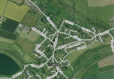
In 1841 the Josephy Burton family can be found living on Hindon Lane, East Tisbury, Wiltshire and working the land (in 1851 Joseph says 28 acres). I'm not sure how they decided what comprised east and west Tisbury back then, but here's an overhead view of the town courtesy Google Maps.

Wednesday, July 9, 2008
The Burtons of Tisbury, Wiltshire, England
Here's something interesting. The earliest Burton patriarch I know about, Joseph, had several sons -- John, James, Henry, William, and Thomas. Thomas was my great, great grandfather and the youngest. In the 1851 census, father Joseph claims to be "farming 28 acres" in the village of Tisbury, Wiltshire. Joseph passed away in 1859, at which time the farm was taken over by son William.
Normally, a farm is passed down to the oldest son. Not so in this case. John, the oldest son, became a mason. James, the next son became a carpenter. Next came Henry, who worked as a innkeeper for a time, then moved to the southern coast of England and worked the remainder of his life as a vegetable gardener and general laborer. It's not until we get to William Burton that we find a son willing to take on the family farm. In 1851 we find him working as a hired hand on a nearby farm. Then, in 1861, he we find him farming his father's 28 acres. Oddly, in 1871 he claims to be farming only six acres. No clue as to what happened to the remaining property.
By the time of the 1881 census, William had passed away, possibly without having any children. At that time the farm doesn't seem to have passed to the other sons as Henry and Thomas had moved away by then and James had died. And I found no evidence that John ever left his work as a mason and took up farming before his death in 1893.
Oddly enough, my great, great grandfather, Thomas Burton, continued to work in agriculture, but not in Tisbury where the family farm was located. By 1851 he had moved 30 miles to the north to the village of Monkton Farleigh where he found work first as an agricultural laborer, then a sheppard, and, by 1881, a farm baliff.
So, I wonder what became of the family farm on Hindon Lane after William died?
Normally, a farm is passed down to the oldest son. Not so in this case. John, the oldest son, became a mason. James, the next son became a carpenter. Next came Henry, who worked as a innkeeper for a time, then moved to the southern coast of England and worked the remainder of his life as a vegetable gardener and general laborer. It's not until we get to William Burton that we find a son willing to take on the family farm. In 1851 we find him working as a hired hand on a nearby farm. Then, in 1861, he we find him farming his father's 28 acres. Oddly, in 1871 he claims to be farming only six acres. No clue as to what happened to the remaining property.
By the time of the 1881 census, William had passed away, possibly without having any children. At that time the farm doesn't seem to have passed to the other sons as Henry and Thomas had moved away by then and James had died. And I found no evidence that John ever left his work as a mason and took up farming before his death in 1893.
Oddly enough, my great, great grandfather, Thomas Burton, continued to work in agriculture, but not in Tisbury where the family farm was located. By 1851 he had moved 30 miles to the north to the village of Monkton Farleigh where he found work first as an agricultural laborer, then a sheppard, and, by 1881, a farm baliff.
So, I wonder what became of the family farm on Hindon Lane after William died?
Tuesday, July 8, 2008
Great, great grandfather, Thomas Burton
My great, great grandfather, Thomas Burton, lived in the village of Monkton Farleigh, Wiltshire, England for many years. On the 1881 census he lists his address as the Monkton Farleigh Church Farm where he was working as a "Farm Baliff." Recently, I found this picture of the Church Farm that is now functioning as a Bed and Breakfast. The converted barn is pictured.

Here's a bit of information on Monkton Farleigh from a Wiltshire government site:
The community was made up predominantly of farm labourers (like my great, great grandfather, Thomas Burton), although there were also clothiers, weavers, maltsters, tailors, shoemakers, carpenters, blacksmiths, grocers, thatchers etc. There are no registers of occupations until 1700. By the 19th century there was a very rapid growth of the industry of stone quarrying and by 1881 Hobhouse stated that nearly half of the labourers were quarrymen. Bath Stone was sent by rail all over the country. The population in 1801 was 264, and in 1851 was 359 (Thomas Burton moved to Monkton Farleigh some time before 1851).
The buildings of Monkton Farleigh are principally two storey buildings, constructed of rubble or of coursed stone (some maybe constructed by Thomas Burton's son, Joseph the mason). They generally display tall, Victorian type chimneys, with stone slate or tiled roofs. Other points of architectural interest include stone mullioned windows and gables. The King’s Arms retains an early 16th century doorway with a 17th century two storey porch, with original windows and a corresponding projection at the back with a circular stair. The Fox and Hounds Inn at Farleigh Wick has curious courtyard and entrance pillars.
The parish of Monkton Farleigh is situated in the extreme north western bend of an isolated chain of hills, at one end of which is Bradford on Avon and another Chippenham. The ground on which the village stands is from 6 to 700 feet in height (733 feet at the Tower on the Down). There is woodland in the south west corner of the parish, as well as small clumps of trees in other places. There is a park and avenue of elms adjoining the Manor House. The village is situated on high ground in the centre of the parish (four miles north west of Bradford on Avon and five and a half miles east of Bath). The village still commands some fine views, especially eastwards. There is sand and clay in the parish, but the soil is generally known as the stone brash. The quarries of freestone are a peculiar feature of the upper or west end of the parish. The A363 from Bradford on Avon to Bath passes through Farleigh Wick, a hamlet at the southern end of the parish. Sir Charles Hobhouse, in his history of the parish in 1881, stated that “probably in all Wiltshire there is no place where the combination of scenery – hill and valley, wood and stream, distance and home views is more varied and beautiful.”

Here's a bit of information on Monkton Farleigh from a Wiltshire government site:
The community was made up predominantly of farm labourers (like my great, great grandfather, Thomas Burton), although there were also clothiers, weavers, maltsters, tailors, shoemakers, carpenters, blacksmiths, grocers, thatchers etc. There are no registers of occupations until 1700. By the 19th century there was a very rapid growth of the industry of stone quarrying and by 1881 Hobhouse stated that nearly half of the labourers were quarrymen. Bath Stone was sent by rail all over the country. The population in 1801 was 264, and in 1851 was 359 (Thomas Burton moved to Monkton Farleigh some time before 1851).
The buildings of Monkton Farleigh are principally two storey buildings, constructed of rubble or of coursed stone (some maybe constructed by Thomas Burton's son, Joseph the mason). They generally display tall, Victorian type chimneys, with stone slate or tiled roofs. Other points of architectural interest include stone mullioned windows and gables. The King’s Arms retains an early 16th century doorway with a 17th century two storey porch, with original windows and a corresponding projection at the back with a circular stair. The Fox and Hounds Inn at Farleigh Wick has curious courtyard and entrance pillars.
The parish of Monkton Farleigh is situated in the extreme north western bend of an isolated chain of hills, at one end of which is Bradford on Avon and another Chippenham. The ground on which the village stands is from 6 to 700 feet in height (733 feet at the Tower on the Down). There is woodland in the south west corner of the parish, as well as small clumps of trees in other places. There is a park and avenue of elms adjoining the Manor House. The village is situated on high ground in the centre of the parish (four miles north west of Bradford on Avon and five and a half miles east of Bath). The village still commands some fine views, especially eastwards. There is sand and clay in the parish, but the soil is generally known as the stone brash. The quarries of freestone are a peculiar feature of the upper or west end of the parish. The A363 from Bradford on Avon to Bath passes through Farleigh Wick, a hamlet at the southern end of the parish. Sir Charles Hobhouse, in his history of the parish in 1881, stated that “probably in all Wiltshire there is no place where the combination of scenery – hill and valley, wood and stream, distance and home views is more varied and beautiful.”
Joseph W Burton & Eliza Jane (Jefferies) Peacock
I'm always interested to find out how my various ancestors managed to be in the right place at the right time to meet. As I researched Eliza Jane Peacock, I noticed that in 1871 she was working as a servant to the Williams family in Bathwick, Somerset. Then I looked up Joesph Burton and found that he was living in Monkton Farleigh, Wiltshire. Here's the map (compliments of MapQuest) that shows where they were each living. (Note, you can click on the map to see it bigger. Use your back button to return to this page).
As you can see, the two were living on either side of the town of Bathampton, just over five miles apart. Maybe they met in one of the local pubs or dance halls in Bathampton. Certainly they could have met on a local train or at the seashore. But Joseph Burton was a mason. He made things out of brick and stone. So, what if the family who employed Eliza Jane as a domestic also hired Joseph to do construction on their property in Bathwick. If so, was it love at first sight?

As you can see, the two were living on either side of the town of Bathampton, just over five miles apart. Maybe they met in one of the local pubs or dance halls in Bathampton. Certainly they could have met on a local train or at the seashore. But Joseph Burton was a mason. He made things out of brick and stone. So, what if the family who employed Eliza Jane as a domestic also hired Joseph to do construction on their property in Bathwick. If so, was it love at first sight?
Tuesday, July 1, 2008
The Burtons of Tisbury, Wiltshire County, England
My father's mother's people were Burtons and lived in and around the village of Tisbury, near Salisbury, in the County of Wiltshire in England. Tisbury is in the Dunworth Hundred. Here's a piece I clipped from the web on Dunworth:
Chalke and Dunworth hundreds are in south-west Wiltshire on the Dorset border. The parishes of Chalke hundred were united by being part of Wilton abbey's estate before the Norman Conquest, but most of the hundred is homogeneous. Long and narrow parishes lie north and south across the river Ebble and are characterized by extensive chalk downs. Until farmsteads were built on the downs in the 19th century, nearly all settlement was in small riverside villages. From the Reformation to the
19th century the earls of Pembroke owned most of the eastern parishes. Sheep and corn husbandry and more recently arable and dairy farming was the pattern of agriculture in all the parishes except Semley where there is a remarkable survival of common pastures. Dunworth hundred is largely in the Vale of Wardour, and land in most of its parishes belonged to the Barons Arundell of Wardour as successors to Shaftesbury abbey. It is an area of broken landscape and mixed farming in which only Tisbury has grown larger than an ordinary village. Except at Tisbury, there has been little manufacturing in the area, but Portland stone has been extensively quarried at Chilmark, Teffont Evias, and Tisbury, and greensand stone has been quarried at the Donheads. Partly because of its stone, Dunworth hundred is notable for its secular buildings. The castle at Wardour is the only one to survive in Wiltshire; Fonthill Abbey in Fonthill Gifford was the most remarkable house of its day in England. Among the many farm houses of local stone which survive from the Middle Ages is Place Farm at Tisbury, which was frequently visited by the abbess of Shaftesbury and has the largest medieval barn in England. Except for Sedgehill parish and part of Donhead St. Mary parish both hundreds are in an Area of Outstanding Natural Beauty: the exceptions are in a Special Landscape Area.
Chalke and Dunworth hundreds are in south-west Wiltshire on the Dorset border. The parishes of Chalke hundred were united by being part of Wilton abbey's estate before the Norman Conquest, but most of the hundred is homogeneous. Long and narrow parishes lie north and south across the river Ebble and are characterized by extensive chalk downs. Until farmsteads were built on the downs in the 19th century, nearly all settlement was in small riverside villages. From the Reformation to the
19th century the earls of Pembroke owned most of the eastern parishes. Sheep and corn husbandry and more recently arable and dairy farming was the pattern of agriculture in all the parishes except Semley where there is a remarkable survival of common pastures. Dunworth hundred is largely in the Vale of Wardour, and land in most of its parishes belonged to the Barons Arundell of Wardour as successors to Shaftesbury abbey. It is an area of broken landscape and mixed farming in which only Tisbury has grown larger than an ordinary village. Except at Tisbury, there has been little manufacturing in the area, but Portland stone has been extensively quarried at Chilmark, Teffont Evias, and Tisbury, and greensand stone has been quarried at the Donheads. Partly because of its stone, Dunworth hundred is notable for its secular buildings. The castle at Wardour is the only one to survive in Wiltshire; Fonthill Abbey in Fonthill Gifford was the most remarkable house of its day in England. Among the many farm houses of local stone which survive from the Middle Ages is Place Farm at Tisbury, which was frequently visited by the abbess of Shaftesbury and has the largest medieval barn in England. Except for Sedgehill parish and part of Donhead St. Mary parish both hundreds are in an Area of Outstanding Natural Beauty: the exceptions are in a Special Landscape Area.
Subscribe to:
Posts (Atom)

