Wednesday, June 2, 2021

Day 28 -- Wendover to Winnemucca, Nevada -- 231 Miles

There's not a lot of points of interest to capture a person's attention when you drive the 231 miles from Wendover to Winnemucca, Nevada. Sure there are lots of tiny towns from bygone days sporting tumble weeds and boarded up main streets; places like Golconda and Wells; places that time has long ago forgotten.

On the positive side, there are a couple of "Don't Miss" options that we always try to include in our itinerary when we're traveling Interstate 80 across the Great Basin. Those two are the Overland Trail Museum on the West side of Elko and the Elko city museum spotted next to Elko's events center and city park. Both are really great places to stop on a lunch hour, or just to stretch your legs after a long drive.

We stopped at the Elko city museum on our way east during the first week of our vacation. They had made lots of changes since our last visit, and we had an excellent time viewing the wonderful art in the changing gallery in the museum annex. We also enjoyed the original part of the museum that we always revisit for its quality displays.

Today, as we drove west, we wanted to stop and visit the Overland Trail Museum hoping to combine a museum tour with our lunch hour. But imagine our horror when we exited the Interstate and drove up to the entrance gate and found it locked! Not satisfied with seeing the closed, and seemingly locked gate from the truck window, I got out and went over to test the integrity of the lock.

Yup, it WAS locked for sure and pasted to the gate was a rather lame message that said: "in accordance with CDC directives, the museum is closed." To help potential guests understand, the sign included a phone number should those guests want to call and have it explained verbally.

Naturally, I called the number since I could easily see two or three cars in the museum parking lot about a thousand feet from the locked gate where I stood. However, as one might expect in such an inane situation, the listed phone number was "not in service at this time."

Now we've been on the road for nearly a month and have been to countless museums and RV camps and grocery stores and, well, you name it, and few are even requiring a mask anymore. Once in a great while we'll encounter someone with a mask on anyway, but they're definitely in the minority. So, we wonder, what's up with the Overland Trail Museum? Evidently, the bad phone number on the gate was going to be no help answering that question.

For a few moments I toyed with the idea of driving in the outbound traffic gate as IT was open. But instead, I just steered the rig back onto the Interstate and continued heading west. It took a while to get over that bit of disappointment, but we focused our attention on our DVD book, though a more improbable story you'd have a hard time finding. The tail involves an Irish family that has decided to become Mormons in the year 1850, and the story details the trials and tribulations they face as they board a ship in Liverpool, England, and cross the Atlantic to New York.

Since the story was meant to be somewhat charming, it managed it keep our interest, but I won't bore you with the plot details. In short, I suspect the family will probably succeed in outwitting everyone from the heavy-handed rich parents of their chance female traveling companion, to the many and sundry American holligans hoping to take advantage of the family's naivete.

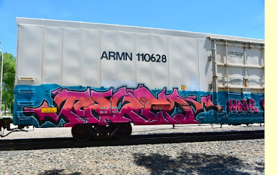
Since we couldn't have lunch at the trail museum, we settled for a semi-shaded lunch spot in a casino parking lot across the street from "The Owl Club Casino and Restaurant" in Battle Mountain, right next to the Union Pacific mainline. Though the line was quiet through most of our lunch hour, a fast freight did announce itself in time for me to grab the camera and dash out to shoot the locomotive. Then, as an afterthought, I started shooting the spectaucularly-color graffiti on the sides of many of the train cars as they sped past at sixty miles per hour.

This brings me to the topic of this blog: railroad car grafitti.

I don't know how many years it has been happening, but painting the name of your girlfriend or streetgang or favorite band on the sides of boxcars, refrigerator cars, or even mesh-sided automobile-carrying cars has become as common as people living on the streets in America. I've never been sure why railroads accept the practice, but maybe it's just impossible to stop.

I visited the "National Railroad Museum" website to learn more about railroad graffiti. They had this to say: "Modern American graffiti, as we know it, began in the United States and is attributed to a Philidelphia high school student known as “Cornbread.” Trying to attract the attention of a girl in 1967, he began signing his name, or “tagging,” public areas of the city."

"The form exploded in New York during the 1970s as “TAKI 183” and “Tracy 168” would “bomb” subway cars with their imaginative signatures, spreading the graffiti idea throughout the region the train traveled. The growth of street gangs and the political and social changes that characterized the 1960’s and 1970’s, whose sometimes illegal and divisive tactics marginalized the art form, while simultaneously bringing it into mainstream American culture."

"Today graffiti is alternately lauded by art critics and enthusiasts, while demonized by property owners, creating tension and discussion within the community about issues ranging from vandalism to free speech."

As you can see from the photos, shooting the cars while they're flashing past is certainly not optimum. But seldom are we ever close enough to parked freight cars to do any photography. Plus, tresspassing on railroad property is seldom safe in these times of home-grown terrorists looking to disrupt society. Railroad employees are specifically trained to look out for folks lurking around on railroad property.

To read more about railroad graffiti go to: https://nationalrrmuseum.org/blog/from-boxcars-to-big-boy-the-story-of-railroad-graffiti/

Tuesday, June 1, 2021

Day 27 -- Springville, Utah to Wendover, Nevada -- 185 Miles

At first I thought that describing today's events probably wouldn't fill a 3"x5" index card since it involved mostly driving under a blazing sun across a witheringly hot desert. There wasn't any fascinating places to pull over once we reached the boundaries of civilization and headed out across the infamous salt flats that straddle the border between Utah and Nevada. Places to stop are few and are mostly exit opportunities for the infrequent side roads.

However, before we departed the green hills of western Utah, I had one important stop to make. If you've been reading this blog as we’ve traveled this spring, you know that our route today is simply a reversal of our departure itinerary from Nevada to Utah in early May. You will probably also remember that once we had crossed into Utah we left the Interstate 80 Route that passes through Salt Lake City and dropped south toward the towns of Grantsville, Toole, Stockton, and beyond.

The purpose of this deviation from Interstate 80 was to enable us to make a very specific stop in the remote desert village of Fairfield more than an hour's drive south and west of Salt Lake City. Back in 1858 this now quiet, sparsely-settled village adjoined a bustling army post known as Camp Floyd, which housed a couple of thousand regular army soldiers.

The army post existed where it did because the U.S. government and the Mormon Church very nearly ended up in a war back in 1857. The reasons for the war can be attributed more to political posturing than to any real threat posed by the Mormon Church, but President Buchanan nevertheless dispatched General Albert Sidney Johnston to the Utah Territory to take charge and "bring order” to the supposedly unruly Mormons.

Mormons, who had been victimized incessantly for more than two decades by various governments, knew what bringing order meant to the U.S. Military. Brigham Young immediately recognized the threat and issued a call to all Mormons to return to Salt Lake City to help defend their church and their brethren. At the same time, young men in Salt Lake City and the surrounding local areas were organized and made ready to repulse an invasion.

In order to delay the army that the Mormons knew was advancing from the east, Mormon's fortified the canyon approaches to Salt Lake City and made ready to ambush any soldiers who might venture there. In addition, cavalry forces traveled east to meet the oncoming supply trains that were traveling separately from the federal troops. Once found, the trains were attacked, ransacked, and put to the torch.

Mormon efforts to destroy the army's supply trains were extraordinarily successful. They were so successful that the army had to halt their advance while still in the Wyoming Territory and wait for more supply wagons to reach them from the east. Ultimately, the army never received enough supplies to wage any sort of conflict with the Mormons and were forced to spend the winter of 1857/1858 bivouacked on the plains in close to starvation conditions.

Fortunately, cooler heads eventually prevailed and war was averted. However the Mormons had to agree to allow a U.S. army post to exist in the Utah Territory for the protection of overland immigrants and as well as all other citizens of the United States. The Mormons agreed to this demand with the stipulation that the fort had to be well removed from any settled areas.

And that's how the fort known as Camp Floyd came to be established, though it only existed for a little over two years. Along with Camp Floyd, the civilian town of Fairfield sprang to life which soon grew into the second largest town in the territory. The Mormons were never comfortable with the existence of the fort, nor of the lawless nature of the town of Fairfield. But opportunities for commerce at both the fort and the town were a boon to local farmers and ranchers for the short time both existed.

Eventually, Camp Floyd was closed and abandoned when the American Civil War broke out in April of 1861. By August of 1861 the Fort was abandoned, the furnishing and supplies sold off, and the soldiers marched off to join in the war effort. Most of the fort's buildings were dismantled for their materials or moved to local farms or ranches, and virtually nothing remains of the fort today save one building which now houses a museum devoted to this particular episode in history.

The museum building once housed the post commissary. Across the street from this sole remaining Camp Floyd building is a two-story structure that was once a way station for both the pony express riders and the overland stage line employees. Concetta and I visited the museum on our way east in May, and photographed the way station. We found both to be well worth a stop to get acquainted with the story of the fort.

Unfortunately, what we missed doing in May was visit the fort cemetery which was situated just down the road to the southwest from the museum. Today I intended for us to recify that bit of oversight. Even though we were told at the museum that only soldiers were buried at the fort and no civilians, I just had to see for myself.

So why am I intersted in the saga of Camp Floyd? Because back in 1861, between the firing on Fort Sumpter that began our Civil War, and the August date that Camp Floyd's troops marched off to fight in that war, my great great Grandfather, John Stephen Daley, was supposedly murdered by Indians, perhaps somewhere in the Camp Floyd area. John, who lived in Springville, Utah, about fifty miles to the east and south, had loaded up his wagon to deliver supplies to an unknown location and was never seen again. I figured if John had been murdered, perhaps the soldiers found him and brought him back to Camp Floyd for burial, especially if he had no identification on him.

Visiting the cemetery today didn't exactly prove that John wasn't buried there, since it doesn't appear that civilians were noted in the record. But he might be there since the cemetery in his home town contains no stone for him that I have found. It's certainly a mystery that I hope to solve someday. At any rate, it felt great to finally get to see a place I've only read about for many years.

And that was our one "adventure" for the day. Right now we're camped in Wendover, Nevada, and tomorrow we'll be headed down Interstate 80 toward Reno. We do plan a stop at the Overland Trail museum in Elko, as that facility is just too good to miss when you're in the area. Tomorrow night we'll be in Winnemucca, which should be our last night on the road.

Monday, May 31, 2021

Day 26 -- Green River to Springville, Utah -- 132 Miles

Today turned out to be exciting and even somewhat out of the ordinary. We rolled out of Green River at our usual hour around 9:00 A.M. and made our first stop a local cut-rate gas station that seemed to have no customers until we arrived. That's usually a bad sign, but since empty gas stations are easier to enter as well as exit with a 32-foot rig, I chose it specifically for its obvious customer absence.

Once we had gassed up, we quickly left Green River behind while using Concetta and her handheld IPhone to navigate us to the tiny town of Springville, Utah, which lay up the road about 132 miles.

As usual, Utah's desert landscape was glowing in the early morning sun, and we enjoyed every mile that we traveled on Interstate 70 and on Utah Routes 6 and 191. Early on we passed through many of the towns that my various relatives spoke about when I was a child. Names like Price, Castle Dale, Soldier Summit, Helper, Scofield, and Clear Creek came and went on the roadside signs as we climbed the grade out of the desert lowlands (photo top left).

When it got close to lunch hour, we just happened to be approaching a roadside rest where we'd stopped at the very beginning of this vacation. I'm not sure what the name of the stop is on the map, but Utah has gone to the expense of erecting a replica railroad station and roundhouse to entertain travelers, as well as installed several charging stations for electric vehicles (photo lower right).

The last time we stopped at this place I had hoped to grab a few photos of the recreated train station and roundhouse, as well as hike up the adjacent hill to the real railroad tracks and grab a photo of a passing train. Unfortunately, that day it was gray and overcast and seemed to be threatening rain, and I didn't end up accomplising any of my goals.

Today turned out to be a much nicer day for fulfilling my previous intentions. Though cloudy, the day was mostly sunny, and I successfully turned our lunch hour into 90 minutes of both eating and taking several dozen photos. The hike up the hill to the railroad tracks was a little tough on this old duffer, but I made it. I didn't see or hear any trains coming, but I just decided to wait until one appeared around the distant bend before I retraced my steps back to the rig.

The first thing I noticed, even while I was down in the parking lot and a hundred feet below my future track-side vantage point, was the wonderful sandstone geological features that had been exposed by the railroad cutting through the mountain for their tracks. There seemed to be alternating layers of creamy, blocky sandstone, and dark, almost black sand or mudstone. You'd have a foot or so of the creamy sandstone, mysteriously broken into large cube-sized chunks. Then you'd have a couple of feet composed of literally hundreds of thin layers of mudstone piled one atop the other. It is possible that the dark layer was mixed with volcanic ash. (photo lower left).

Every time the sun would pop from behind a cloud and illuminate the hillside, I would fire off as many photos of that incredibly interesting geology as I could. Then, since I was still waiting for the train to arrive, I spent the overcast moments both looking for artifacts and studying exfoliated pieces of the cream-colored sandstone for evidence of fossils. Sadly, and try as I might, I didn't find any fossil evidence.

Meanwhile, a hundred feet below me in the parking lot, Concetta was beginning to think I had gotten totally lost. But when I finally gave up waiting for the train, taking photos, and looking for fossils, I hiked back down the mountain and let her know I was still alive. But, I told her, I was headed back out again because on my walk back to the rig I came across a couple of RVers who were in need of some assistance.

Before arriving at the rest stop, these RVers had noticed that the "skin" on one of their driver's side lockers had peeled off the support structure and bent double in the slipstream. They wondered if I had any Bungee cords, and I told them that I did, and I would go retrieve my collection and return.

After telling Concetta about my mission, I rummaged through my emergency stash, pulled out my container of Bungees and, for good measure, grabbed a brand new 50-foot roll of eighth-inch nylon line. Once back at their rig, I saw in my absence they had tied up the locker door skin with a knotted length of coaxial cable, which seemed to do the job. However, I insisted that they take my roll of nylon line just in case.

I always thoroughly enjoy helping out other RVers. More than once in our travels we too have been the recipients of some very good deeds by both fellow travelers and by members of the public we have encountered quite by chance.

During all this time, the train still had not appeared on the tracks above the rest stop, so we decided to move on. Naturally, we hadn't driven more than a couple of miles, and we passed the train coming up the canyon. Had I been able to remain just another half hour, I would have had my shot. But oh, well, better luck next time.

Amazingly, we hadn't driven more than another quarter of an hour, and we rounded a bend and encountered a huge two-lane traffic jam. When I say huge, I mean the double line of cars, trucks, and RVs of all descriptions stretched ahead as far as we could see down the canyon, perhaps as much as three miles, before it disappeared around a distant bend. We both assumed that there must be some giant accident like an overturned oil tanker or six-car pileup to create such a mess.

Very quickly our rate of travel was reduced from 60mph to less than 5 mph. We kept going, but you could almost walk as fast. Foot-by-foot we crept over the hill and down the canyon, side by side with a multitude of folks doing the same thing. Unfortunately, we had only just finished our murder mystery so didn't have that entertainment to take our minds off the tedium of the jam. I went ahead and popped John Denver into the machine, and we listened to "Rocky Mountain High," and other Denver favorites.

When, after nearly an hour, we finally arrived at where the two lanes became one lane, traffic suddenly took off like a shot, and we rolled away from that point at our usual 60mph. To our astonishment, there had been no huge accident at all. The entire debacle had to be chalked up to the Memorial Day traffic overtaxing the carrying capacity of Utah Highway 6/191.

Once past the jam, we very quickly rolled into Springville, our destination for the night. Rather then head right for the camp, we took what we hoped would be a few moments for me to stop by the Springville Cemetery and visit the grave of my two times great grandmother. Here in Springville my Mormon ancestors have lived and prospered since the first wagons arrived in 1847.

Alas, though I have located the grave in the past, and have even photographed it, I was unable to locate it today. I strolled around for a good forty-five minutes, but never saw a single "Daley" family member grave. After that bit of disappointment, we traveled on to our KOA camp in Springville, thus ending a really fascinating day.

Sunday, May 30, 2021

Day 25 -- Montrose, Colorado to Green River, Utah -- 162 Miles

We just drove today and listened to a murder mystery by John Sandford. I thought the story believable and well told as well. Makes me kinda miss my mystery-writing days way back when. Although I finished my one and only attempt many years ago, I couldn't interest an agent in the book. So, I moved on to bigger and better things.

One of those bigger and better things has been traveling, a passtime in which I have been desperately in love since my folks took my brother and me on our very first vacation back when I wasn't old enough to spell vacation. Later, when Mom discovered genealogy and we spent most vacations exploring the western United States in search of our ancestors, my love for seeing our magnificent country grew exponentially.

In those days the predominence of our ancestors lived in or around Utah and Colorado, so that's where we did much of our traveling. Today, "the Happy Wanderers" just happened to be traveling between Colorado and Utah, and we took a few photos along the way. We didn't stop to do any exploring, but included here are a few shots of the scenery along our route of travel (photo above).

Quite at random, we chose as our lunch hour stopping place a patch of ground off Interstate 70 that just happened to contain a cell tower. The tower must have belonged to Verizon as our internet devices were extremely pleased with our choice (photo below).

The 18-wheeler you see in the the above photo was sitting on the shoulder of the on-ramp when we drove up. I took so many photos of the rig while I was looking for good shots of the sky that I think it made the driver nervous, and he soon cranked up his truck and drove off. Here's another shot of the truck below.

As an added benefit, while tramping around looking for photo angles, I found on old cast-off RV sewer hose that had obviously lain out in the desert for years. Still, even though the hose was useless, the fitting on the end, which came complete with a Jubilee Clamp, would be super useful to someone in an energency.

We had encountered just such an emergency in our Steamboat Springs camp this trip. Two female campers next to us had just laboriously completed setting up their camp and discovered, to their embarrassment, that their sewer hose was three feet too short. They had two separate sections that would work to extend their reach, but they had no connecting device to join the two sections. Their only other choice was to break down the camp trailer, move it three feet, then set it up all over again.

Thinking that I probably had some sort of fitting in my stash of largely unused spare equipment, I dug around and found just the perfect connector. I hadn't used the piece for years and years so offered it to them, and I even offered to do the installation. Twenty minutes later they were all set up and super happy. I could easily envision the connector that I found today coming in handy in just such an emergency in the future.

So anyway, here are the photos, and as you can see, the main subject today was the magnificence of the sky and it's super expressive clouds. Enjoy!

The photo above was crafted using three separate shots. Nothing fancy, just a bit of Microsoft Paint. Just wanted to see if I could do it.