Saturday, May 15, 2021

Day 10 -- Breckenridge to Steamboat Springs, Colorado -- 102 Miles

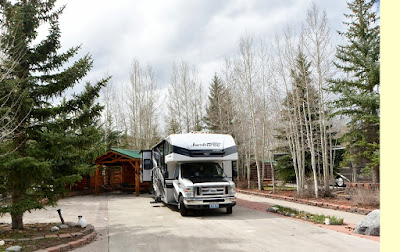
Well, having spent the night at the "Tiger Run Resort" in Breckenridge, Colorado (photo left), we can absolutely recommend the camp to anyone and everyone who, like us, spends their time wandering the country looking for adventure. As I wrote yesterday, the spotless camp is more like a picture postcard of a camp than any real camp in which we've ever parked our rig. Everything is spotless and well maintained. The laundry room this morning was immmaculate and sported machines that took credit cards in case you forgot your roll of quarters. I couldn't have been more impressed.

Checking out this morning, I spoke once again to the super friendly Italian girl from Venezuela who was just thrilled to have had us as guests and wished me a safe journey and told me she hoped we'd return someday. That prompted me to ask her what months I should avoid in the future and she was quick to recommend that I avoid July and August as they are habitually booked for those two months well in advance.

If you're thinking of visiting the Tiger Run Resort, I would definitely recommed that you call in advance before showing up as we did. We were fortunate that we got a spot without a reservation. The town of Breckenridge, should you have transporation or arrange transporation into town, should keep you busy for however much time you have to spend.

We didn't drive that many miles today, but we decided to do laundry first thing this morning which held us up a bit. Plus, the route I set out for us was our usual two-lane ribbon of asphalt that was mostly up hill and down dale and twisty as a coiled rattlesnake. We were hoping for sunshinve today, and we got our wish at first. But it soon became apparent that our future probably held the strong possibility of rain before we reached our camp for the night.

The route we chose continued to avoid the most heavily-populated regions in favor of places that no one bothered to go. For that reason we chose Route 40 out of Breckenridge as it went north toward Steamboat Springs and north was our favored direction of travel. Trouble was, you had to drive east on Interstate 70 for twenty-five miles to reach the junction with Route 40. Instead we decided to go west and jump on Route 131 north which also led to Stearmboat Springs. The distance traveled was negleable and it also afford us an opportunity to stop and gas up the rig.

We thought that Route 131 would be mostly vacant of traffic in either direction since it was well off the beaten path. What we didn't know was that Route 131 provided an easy access for those who wanted to do some river rafting on the Colorado River which crossed Route 131 ten or fifteen miles above the I70/Route 131 junction. In addition, there must be some fine fishing and off-road motorbiking in the area as we encountered more than few folks taking advantage of both those pursuits.

The going was slow as the grades were steep, both up and down. But what I liked was the wonderful visitas and the intriguing varieties of geologic formations that we passed. Most of the time we couldn't stop to photograph those formations, but there appeared to be a huge variety of including volcanic and sedimentary. At one point we stopped to collect rocks for our rock garden at home and Concetta managed to find what was obviously a metamorphic rock that is known to geologists as breccia.

Breccia is what you get when bits and pieces of rock that weather out of larger formations, along with sand or mud, are buried deep enough (like miles down) to become super heated by pressure and begin to form an amalgum. Later, when this amalgum cools and weathers out at the surace you get a base rock with the appearance of having foreign bits of other rocks embedded (photo above right). This rock is neither volcanic nor sedimentary.

The other geologic oddity that we saw today as we motored north on Route 131, just west of 11,978 foot Trappers peak, was a whole "field" or valley full of volcanic plutons (photo left). A pluton is a sort of "dome" of magma formed underground. The dome rises or intrudes between other rocks and never reaches the surface to form a volcano. Since it cools below the surface, you never are aware of plutons unless the surrounding land erodes or weathers away sufficiently to expose the solid magma formation.

We could hardly believe our eyes as we encountered the first pluton on Route 131. Because of the nature of the highway, we were unable to stop and photograph the first one we saw. But soon we encounterd another, and then anther, until we had counted no less than five within a five-mile stretch. Fortunately, I was able to photograph a couple of these plutons for the blog.

To illustrate a pluton that you might already know about, think about the Devil's Tower in Wyoming that you may have seen in "Close Encounters of the Third Kind." Closer to home, if you're a Nevada resident, I believe that Cave Rock at Lake Tahoe is a prime example of a Pluton.

The remainder of our day was pretty mundane as we rolled along without incident, did a bit of shopping at the Safeway in Steamboat Springs, then headed for KOA at the north end of town (photo right). Though I got a lecture for not making a reservation from the desk clerk, the camp is pretty nice overall. I tried to explain to the clerk that we seldom have any idea how far we'll drive in a day, but I don't think she was impresssed with my explanation.

Once we arrived at our campsite, I actually spent more time helping the two young campers next door with their sewer line problem than I spent getting our rig set up. But sometimes you just have to do what's right in the moment. And, though we were threatened with rain the whole time I worked outside, I never did get wet. In the end, all was well that ended well.

Friday, May 14, 2021

Day 9 -- La Junta to Breckenridge, Colorado -- 198 Miles

Since arriving in La Junta (Spanish for "the junction") yesterday, I've been trying to decide which direction I should suggest to Concetta that we drive. We'd visited Bent's Old Fort, the one place I definitely intended to see on this trip. Concetta said that she'd go with whatever direction or destination would someday get us to Idaho, as she would really like to see more of that state. Since Idaho was north and west of us, there really was no sense going east into Kansas. In fact, in our most recent trip we had traveled through Kansas, and had even seen the infamous cow town of Dodge City. Grabbing the atlas, I poured over the Colorado page looking for a scenic way to head north from La Junta.

If you've read many of our blog entries in the past you know that most of the time we try to avoid the blue Interstate highways. On this leg of the trip we definitely wanted to avoid the traffic and congestion of the Interstate 25 corridor that runs north and south through Denver and Colorado Springs. What I ultimately hit upon was for us to head west on lightly-traveled Interstate 50 until we reached Canon City, Colorado. Just west of Canon City, we could jump on Colorado Route 9 and go in a northwesterly direction that would completely miss all the hustle and bustle of the Denver/Colorado Springs metro areas. In the process we'd get to travel a lightly-used, two-lane road that neither of us had ever driven, and perhaps visit a couple of early mining towns in the process.

Even though we seldom travel the blue highways in our travels, and almost always stick to the narrow two-lanes, even we were surprised at the absolutely stunning vistas of majestic plains and thick green forests that we saw today on Colorado Route 9. We had to take it slow due to the many twists and turns and changes in elevation, but this snail's-pace really allowed us to enjoy every single mile.

At one point, when we crested a hill, the unimpeded view of the far off, snow-coverd Rocky Mountains spread itself across our windshield, extending even into our side windows. We were just totally awestruck. Neither of us could remember EVER witnessing such a breathtaking vista.

Unfortunately, there was no place to stop and photograph the unequalled magnifience of that chain of peaks. Seldom, if ever, was there even the tiniest shoulder on which we might pull over and photograph some of the beauty we saw. It can be quite frustrating. We so often had to be satisfied with just being present in the moment as one of the most beautiful drives on the Continent unfolded before our eyes and stretched beyond the far horizon.

At first the day was sunny with just a hint of rain clouds far to the west. But throughout the day more and more rainclouds gathered around us and seemed to further curtail our photographic efforts. Though we only experienced a few sprinkles on the windshield, the threatening skies and low light levels finally did in our enthusiasm for clicking the shutter at every turn.

Our intention was to quit driving early today and attempt a bit of laundry. That being decided, we set our sights on a camp near the town of Fairplay, Colorado. Unfortunately we somehow missed our turnoff to that camp, and before we knew it we were already headed north out of town. Instead of finding a place to turn around, we revised our strategy and decided to drive on to the next town of Breckenridge, Colorado.

As I told Concetta, I had heard about Breckenridge for years, but my mental image was of a scenic minning camp and semi ghosttown that had ultimately become a ski resort something like Aspen. My expectations turned out to be way wrong. The reality of Breckenridge is light years from my mental image and nothing short of incredible! The whole down is buzzing with lights and people and commercial activites and rows of new buildings and traffic circles and an overhead tram and, well, you name it. It looked to us like every young "with it" person from a dozen surrounding states has come here to spend their vacations and be cool.

The camp where we're now located looks more like a picture postcard of a camp than one of the rough and tumble camps we normally frequent. Each site has a large concrete slab on which to put your rig, and each site is landscaped with river rock, aspen trees, and small pines. The whole camp is in fact a resort subdivision with streets and cross streets and a rec center and tennis courts and cabins to rent if you don't have an RV.

We're not sure what wildlife comes with the space we rented, but we just had a beautiful red fox come and spend about a half hour sitting in the unrented space next to us. He sat quietly, just watching the few walkers and RVs go by while I took a bunch of photos of him. I figure he must have a "den" somewhere in our block because every once in a while he disappears somewhere and then returns in ten or fifteen minutes to resume his vigil.

While I was setting up the rig, Concetta went in search of the laundry facility and returned to say that the machines were all in use, but the facililty was immaculent. We're planning to get up early and try and get the sheets and towels done before we leave. Beyond that we're not sure what our plans are for tomorrow. The nice Italian girl from Venezuela in the registration office told me that she was giving us a space in which we could stay an extra night in if we so chose. So maybe something will turn up to take our fancy. Maybe we'll find a way to go ride the tram that runs to a mountaintop here somewhere?

Thursday, May 13, 2021

Day 8 -- Lathrop Park to La Junta (via Bent's Old Fort) Colorado -- 95 Miles

People are always asking us where we're headed when they learn that we're traveling across the country and enjoying life on the road in our RV. And without fail, we always tell them that we're not headed anywhere in particular, we're just seeing America. "That must be nice," they'll usually say, a far-away look in their eyes. We know, at that point, that they are visualizing themselves in retirement someday, just hitting the road and going in whatever direction the wind blows; taking life as it comes.

In fact, I just had this conversation yesterday at the tire store with a twenty-something young man who was torquing the wheels onto the front axel of the rig. He was showing quite a bit of interest in owning an RV and we had quite a nice conversation as I gave him a verbal list of what to do and what to watch out for. He seemed really intersted, and I expect he'll get there someday.

Inside the tire store, Missy, the young lady who sold us the tires, was also a bit misty-eyed as she told me about her parents and about their great love of RVing which her dad had to give up when Missy's mother passed recently.

I know the topic is near and dear to just about everyone who has spent some time on the road, or camped alongside their favorite lake, or perhaps even vacationed with grandparents. It's why we encounter so many rigs on the road everyday. Just about everyone wants to get in on the action.

Just about the only concrete goal I had for this summer's trip was to visit a place I'd long read about in my researh on the Santa Fe Trail, and that was Bent's Old Fort. Starting in the 1830s, entrepreneurs hit upon the idea of hauling wagonloads of goods the 700 or 800 miles from Independence, Missouri to the Mexican village of Santa Fe, now NEW Mexico. Though the Mexican government wasn't totally thrilled with the idea, the need for goods of all descriptions was so great south of the border that officials tended to look the other way after exacting a few "taxes."

Litterally, one successful trip for an American who brought a small wagontrain of goods to Santa Fe could make that American a wealthy man. Hence, lots of budding businessmen tried it. And though many failed when their trains were attacked by one of the many native America tribes along the way, enough merchants were successful to make the journey to Santa Fe an unbeatable opportunity to become rich.

Keep in mind that at this point the United States basically ended at the Arkansas River about midway down in the state of Kansas today. Below that line, and west of Bent's Fort, just about all the land beloned to Spain, then Mexico. In the United States civilizaton pretty much ended at the north/south line of the Missouri River. From there to the west coast only fur trappers dared to venture.

So it was that three partners, Charles and William Bent, along with Cerah St. Vrain, decided that all those overland caravans traveling between Independence on the Missouri, and Santa Fe in Mexico, could surly use a place to stop and refurbish their supplies, replace worn-out animals, and rest if the journey had been difficult.

What was needed, the three partners decided, was a sturdy adobe fort that could serve a multitude of purposes, from a supply point for overlanders, to a home base where trappers could sell their furs, from a defensive position in case of Indian attack, to a place for friendly Indians to gather and trade for goods. The idea seemed foolproof.

Bent's Fort, which we visited today, is actually a reconstruction of the first of two forts that the Bent's built on the banks of the Arkansas River. According to guide books, the fort is faithfully reconstructed using original drawings so as to be as period correct as possible. From what Concetta and I saw today, they did a fantastic job right down to the furnishing of all the various rooms and workshops. I was especially impressed with the carpenter and blacksmith shops where all the tools one might expect to find in such shops were present and looked to be ready for their tasks.

I first started reading up on Bent's Fort and the Santa Fe trail when I wanted to know if the death of my two-times great grandfather's brother, Stephen Daley, who died August 15th, 1847, during the time of the Mexican War, had been working as a teamster on the trail. I believe that at the time that Stephen and my two-times great grandfather, John Daley, were working as teamsters in Missouri, and during the war teamsters were in great demand. Unfortunately, though I was able to find out that in the year 1847 some 15 teamsters had lost their lives somewhere on the Santa Fe Trail, the names of those teamsters were not recorded.

Wednesday, May 12, 2021

Day 7 -- Peacock Meadows to Lathrop State Park, Colorado -- 116 Miles

Well, as my dear mother used to say, today was a “real humdinger!” But first I’ll have to bring you up to date on last night’s camp in Peacock Meadow on the east side of Wolf Creek Pass

As so often happens to us on these sojourns across America, we were searching for a camp we had seen in the Good Sam guide book and sort of stumbled into Peacock Meadows quite by accident. By then we were both tired of driving AND ready to unwind after ascending and then descending the steep and daunting highway over Wolf Creek Pass.

The camp didn’t look like much as we rolled up next to the office and stopped. As I got out and approached, I was immediately put off by the sign on the door which announced that the manager was off patrolling the grounds, or something like that, and no one was there to check me in. A scan of the several dozen spaces which hugged a gentle hillside to the north of the office revealed no movement and no such manager in sight.

I got back in the truck and told Concetta that we would just pick out a spot, since the park was largely empty, and we’d let the manager find us later. And this is what we did, or at least tried to do. Seconds after rolling away from the office and down the gentle slope to the the first string of camps, the manager miraculously appeared right in front of us and halted our progress.

He threw open the window cover of his ATV and said, “where are you going?”

I simply told him what we had planned to do.

Didn’t you see the list of available spaces?” he asked.

”Nope,” I said. “I just figured that most of the spaces seemed empty and we’d just find one we liked.”

With a slight edge to his voice the manager said, “Well, there’s really only about five available,” and at that point he proceeded to enumerate each one of the empty spaces and point out there location.

I told him that I guessed that space 43 would do.

”Okay,” the manager said. “Wait right here.” And then he went charging off in his ATV to do God knows what and then returned to guide us to the spot.

By this time the guy had began to soften his demeanor, and I actually began to like him. He led us around the park past a couple of score of empty spaces and then helped guide us into space 43. After I had backed the rig into the space, the manager, whose name was Ron, and I got into the ATV together, and he took me up to the office to get the check-in envelope. By the time we had returned to the rig to get a check from Concetta, he and I were best buddies, which we remained for the remainder of our stay. We talked extensively, as did he and Concetta.

Turns out he was a contractor in New Jersey until the real estate crash in 2008 which effectively put him out of business. At that point he and his wife pointed their noses west and ended up in southern Colorado as camp hosts. Ron ran a scrupulously clean and tidy camp, which was true of even the laundry facility. The camp was pretty bare bones, but it was quiet, peaceful, and located in a beautiful valley beside a meadow and running river. It was so nice that we really hated to leave this morning, and we truly hope we will be able to return someday.

Today main’s objective was to find a tire shop to take a look at our suddenly alarmingly worn right front tire. Motor homes, they tell me, are notoriously hard on front tires and ours was no exception. As we traveled through villages like South Fork and Del Norte on Route 160 in southern Colorado, we diligently scanned both sides of the street for tire stores. But it wasn’t until we reached Alamosa that we found a store that could help us.

I pulled the rig into the parking lot of “America’s Auto Care and Tire” and smiled when I saw that their tire bays were not all occupied. As I parked near the edge of the tire store’s lot, I cranked over the wheel before turning off the engine so a technician could see the part of our tire that had concerned me. When I got out and looked at the tire I nearly quit breathing. The inner edge of the right front tire was down to the fabric. I decided on the spot that the rig was going to get to new front tires if the store had the size we needed and no excuses.

To make a long story short, America’s Auto Care and Tire DID have our size of tire and those folks literally treated us like royalty. I worked with a couple of employees whose names were Darien and Missy, and they treated us like family the whole time we were there. Not only did they rush us right in and get started on our project, but they finished so swiftly that we barely had time to finish our lunch, which we ate while the tire changers were busy. In total, I probably spoke with four or five of their people and each and every one of them was courteous, professional, and extremely helpful. I was so impressed that I told them I was taking the whole crew to lunch and I handed them a fifty to cover at least some of the cost. Should you ever be cruising through southern Colorado on Route 160, keep them in mind for their excellent service.

Breathing much easier with brand new tires on the front of the rig, it was time to play. Very soon after leaving the tire episode in Alamosa, we came to a turnoff announcing the existence of Fort Garland nearby. Naturally, we immediately turned right and soon were parked next to the museum.

As sometimes happens, the entrance to Fort Garland wasn’t exactly impressive, however once we started on the tour we were totally blown away. Fort Garand, which existed from 1858 to 1883, was for a time the home of one Kit Carson, whose name you may recognize from our home town of Carson City, Nevada.

The Fort is very plain and unimpressive from the outside, but the job the volunteers and docents have done on the inside of the various fort buildings is absolutely astounding in its completeness. Much of the adobe walls of the various buildings are still there, as is much of the wood-timbered roof rafters and sheeting.

Inside the various buildings are everything from life-sized exhibits of arms, uniforms, and everyday living utensils, to actual furniture. In some buildings incredibly crafted dioramas of life at the fort and surrounding ranches are depicted. I was so impressed I could hardly keep my finger off the shutter button.

After the Civil War, from 1866 to 1867, Kit Carson commanded the New Mexico Volunteers at Fort Garland. As the brochure says, “Drawing on his knowledge of American Indian languages and culture, Kit aided Chief Ouray and other Ute leaders in the negotiations that created the Ute reservation."

Even more interesting, African-American cavalrymen, the famed “Buffalo Soldiers,” served at Fort Garland between 1876 and 1879, and the museum includes a whole room devoted to the Buffalo Soldiers’ experience at Fort Garland.

After Fort Garland, we needed to conclude our amazing day by finding a suitable camp for the night. Checking the Good Sam book, we found that just up the road a few miles was a state camp known as Lathrop State Park. Since it was the only camp in our immediate vicinity, we set our course for Lathrop and found it without difficulty.

On the down side, our electrical surge protector strenuously objected to the power coming out of the 30 amp outlet at our site, so right now we’re just using the 110 volt which seems to be working fine. There’s no water here, but fortunately I topped up the onboard tank this morning so we have plenty of water. No running water, reduced electricity, and we’ll have to use the dump station tomorrow morning when we leave, however the scenery here in this camp is absolutely stunning. We’re completely surrounded by a forest of vibrant green junipers and way off in the distance is the snow-covered, matterhorn-like peak of 13,625 foot West Spanish Peak. What more could you ask for?

Tuesday, May 11, 2021

Day 6 -- Cortez to South Fork, Colorado -- 146 Miles

Today was the event for which Concetta and I had looked forward in excited anticipation since we left Carson City. Not since the summer of 1977 had we visited the incredible anthropological/archeaological site of Mesa Verde, Colorado, one of the premier such sites in all of America. We two have been married for more than 44 years, and not since the days when we both were single did good fortune bring us to Mesa Verde.

So today, it was with a tremendous sense of bouyancy that we reached Mesa Verde's exit on Colorado Route 160 and rolled into the parking lot. The first thing we noticed was that the park now had a visitor center very near the highway exit and, wonder of wonders, they had thought to provide parking for RVs.

Unfortunately, that's where our euphoria began to ebb. The spaces provided for RVs were in no way even remotely level, a feature we always seek if possible. RV refrigerators function much better when you keep them level.

Our next bit of disappointment came when we saw the line in front of the visitor's center. Perhaps twenty-five people are standing patiently in front of the door which made it all too obvious that they were limiting access to the visitor center to a few individuals at a time.

I motioned Concetta to grab a place in line while I went over to where a young female ranger sat actively acquainting a young man with where he could and could not visit while in the park. It didn't take me long, as I listened to their discussion, to realize that we would NOT be going to parts of the park that we had explored on our 1977 visit.

When the young man left, I stepped up and asked if the ranger recommeded the trip up the mountain for large RVs. "Sure," she said with a smile, though she sort of wrinkled her nose when I told her ours was thirty-two feet long. She asked me if I was towing a car that we could drive up the mountain instead and I told her no.

"You can go most places," she said, "but the museum is closed at the top. You can drive the road to the museum, but you have to skip the Wetherill Mesa Road on the right here." She pointed out the road on the map. "It will take you about an hour to reach the top and an hour back," she finished.

Right about then I began to realize that two hours of driving to see a mesa full of junipers and distant cliff dwellings was not going to fulfill all our dreams of adventure, and I suspected that Concetta would feel the same.

About that time it was our turn to access the visitor center which, as we soon discovered, was not open for business either. Only the gift shop was open, and we dutifully took a turn through the racks of t-shirts and books on Native American culture. We didn't really get to ask any questions or visit with anyone. I picked out a couple of small picture books on edible plants and medicinal plants so that I could make my contribution to the upkeep of the park, and we quickly left to give someone else a chance to do the same.

After leaving the visitor center, Concetta and I discussed whether two hours of driving to accomplish little else but driving was going to make us happy, and she said no, it wasn't. So, we took a couple of photos, helped along by a chance passerby, then trudged back out to our RV and set off for points east. It should be pointed out, however, that had we been interested in a bit of hiking out to some of the distant visita points, we could have made better use of our two-hour drive. But since my knees won't allow such hiking activities anymore, we had to pass.

Our next port of call was the once sleepy, now bustling town of Durango, Colorado, where the famous Durango and Silverton train rides can be had. We already knew that the train wasn't running, or we might have sought tickets or at least standby status for such a ride. If you haven't ridden the Durango and Silverton, you have missed one of life's truly magnificent experiences. It's been many years since we rode up to Silverton, but on that occassion it was our anniversary and we stayed the night in a Silverton B&B, strolled the town after the tourists had left for the day, and enjoyed some great honky-tonk music pounded out by an octagenerian at one of the local saloons. My God that was high times.

This time, rather than ride the train, all we wanted to do was find a tree-shaded back street and have our lunch. But first we had to get some gas for the rig, so we eased into a tiny station not quite big enough for us on the west edge of town. There wasn't much business in the station, thankfully, and in a short time I had topped up the tank, replaced the cap, grabbed my receipt, and headed back to the driver's seat.

Have you ever watched that scene in “Back to the Future” where Marty McFly hurriedly jumps into the DeLorean, turns the key, and instead of hearing the engine roar to life, all the electronics in the car just die right there on the spot? Well, our RV decided to try that same stunt on us today.

When I got back in the cab after filling the tank, I fastened my seat belt, stuck the key in the ignition, and turned the key. Briefly the dash lights came on, then all the electronics just died. Concetta and I looked at each other dumbfounded.

“Do you think it’s the same problem we had in upstate Michigan last trip,” she asked.

I tried to imagine a worse place to break down than the busy gas station where we were parked blocking not one, but two pumps. “I guess it could be,” I told her. I pulled the hood release and got out to take a look.

Back in 2019, I had tried to troubleshoot the rig's running lights one morning when I discovered they weren’t working. We drove the rig to the nearest town and stopped at an auto parts store to buy fuses. It was there I somehow ended up accidently disabling the truck for a whole day. Not even the men who the Ford dealer sent to our location could figure out what I had done. After having the rig towed back to the dealership, we learned that the Ford folks "thought" they could get to us in a day or so.

That night we got to sleep in the rig in the Ford Dealership parking lot much chagrined by the whole turn of events. The next morning, schematic in hand, I popped the hood again and managed to locate the spot that I thought should contain a fuse and didn't. I wondered if perhaps the missing fuse was causing the problem, so I popped one in just to see. Incredibly, the truck instantly fired right up when I turned the key. Soon we were back on the road, but not before I got a job offer from the Ford crew for fixing the truck on my own and without any help from them.

This time I hadn’t been fooling around under the hood. In fact, I hadn’t been working on anything at all. With the hood now open, I located the fuse that had caused us so much grief in 2019, but a quick inspection showed nothing abnormal. Now I was really getting apprehensive.

It was at that point that I accidently brushed my arm against the positive terminal of the battery and I felt the battery cable move slightly. I took a closer look. Sure enough the terminal cable was loose, as was the nearby negative terminal cable. Guessing that when I had cleaned the terminals in anticipation of the trip, I had obviously neglected to tighten the cables on the terminals again. We had motored all the way from Carson City with those cables loose. Holy Cow!

Well, reseating the cables in the gas station brought the truck back to life, and with satisfied sighs we motored merrily away. And when I say merrily, I mean tremendously, unequivocally, uproariously M-E-R-R-I-L-Y! Then, as soon as we found a suitable lunch spot and parked, I grabbed my trusty crescent wrench and tightened those pesky cables down firmly. Yet another disaster averted.

Since there was nothing we planned on seeing in Durango, we soon jumped back on Route 160 east and quite enjoyed the rest of our day just lazing along, marveling at the magnificence of the Colorado mountains and forests, and heading toward our camp for the night in South Fork, Colorado.

There was only one impediment in our path -- that of Wolf Creek Pass, elevation 10,857 feet above sea level. Now if any of you have owned an RV, you know that you better have a decent engine in that RV if you plan to tackle the lofty passes in Colorado. Our first rig, a 1996 Fleetwood Tioga had a nice, large Ford motor, about a 460 cubic inch monster if memory serves me correctly. But that truck would still drop down to 30 miles per hour over some of the highest Colorado passes.

Our new(er) Ford rig sports a V-10 motor which is just the greatest thing ever. I'm not sure of the cubic inches, but for some reason our Fleetwood Jamboree climbs giant hills -- like Wolk Creek Pass -- like there's nothing to it. We even passed a heavy duty Ford pickup hauling a small, light-weight travel trailer as we climbed to the summit.

So it's four-thirty and we are all set up at the Peacock Meadows RV park on the far side of the pass and have just learned that their internet connection is on a fiber-optic connection. Now that's way cool. I'm here typing the blog while outside the window a herd of deer are browsing in the sagelands, and all seems right with the world.

Monday, May 10, 2021

Day 5 -- Green River, Utah to Cortez, Colorado -- 166 Miles

The shady Acres RV park in Green River turned out to be first rate by our standards. How do we rate "first rate?" Well, first of all it has to have an immaculent laundry room. Not having significant laundry to do, we were not able to gauge our item number one. But the rest of the list is as follows: the park should be far enough off any busy highway to avoid incessant road noise; the spaces in the park should be comfortably far enough away from each other to make noise from our fellow campers insignificant; there should be a concrete patio where you access the rig; all the utilities should be up to date and not present a hazard in their use; the sites should be as level as possible given the terrain; pets belonging to our fellow campers are kept quiet and on leashes; and access to trash collection points is clearly marked and not a football field's length away.

Naturally, trees and grass and other ornamentals are always nice, but the possiblity of such luxuries is always dependent on the age of the park, the local climate and water restrictions, and the location and elevation in the country. We've been in all types of camps from heavily treed to no trees in sight and have had a good time in each. We don't even mind graveled sites if kept up with fresh applications of gravel once in awhile.

This morning our main goal was to visit the John Wesley Powell Museum in Green River where we turned out to be the first guests of the day. Since neither Concetta nor I had ever studied the life and exploits of Powell, we were completely surprised and charmed by the level of expertise with which the museum's founders and docents had presented Powell's life and exploits. But they didn't stop there. No, many more of the noted men and women who had subsequently made the trip down the Green and Colorado rivers were just as effectively displayed, explained, and celebrated.

Though Concetta and I chose not to become intimately acquainted with the whole fraternity of river-running figures in history, any reader out there who counts river rafting and boating as one of their passions has all the material available should they choose to visit the museum and learn about the lives of these river pioneers, even to the extent of viewing the historic wooden boats in which they often made river-running history.

Starting in May of 1869, Powell and his companions were the very first to navigate the Green River down to the Colorado River, then all the way through the Grand Canyon. Amazingly, they did it in wooden boats, three made of oak and one of pine as I remember. They had no waterproof clothing. They wore no life jackets. They simply hoped that they had enough grit and determination to see the job done.

The men put in on the Green River in the state of Wyoming and at first things went pretty smoothly But as they began to encounter increasingly rougher white water rapids once they reached the Colorado, Powell's companions started to feel just a bit uneasy. When one of the four boats was dashed to pieces against some heavy bolders in a series of rapids, several men began to speak quietly of hiking out of the canyon and not completing the trip

After several days of such discussions three men finally decided to leave, one of whom had been on the shattered boat and had desterately clung to a mid-stream bolder until rescued by another boat. Sadly, none of the three who were last seen climbing out of the canyon, were ever seen again and were probably slain by Indians.

It took Powell and his crew about three months to make the whole run successfully. They did it without any loss of life, save the three who abandoned the river-running effort.

After our museum visit and a brief pause in the gift shop, the Happy Wanderers jumped in the waiting RV and set our course for the state of Colorado. Our intended camp for the night was to be in the town of Cortez, Colorado, just a short distance from the famous and fabulous Mesa Verde National Park. Mesa Verde is near and dear to us as we visited this one-time home of the Anazasi cliff dwellers on our very first southwestern vacation back in 1977. I had known Concetta for less than a year when we set off in her mechically "struggling" 1964 VW bug which sported a top speed of 40 miles per hour.

We had had her VW serviced in Carson City and the mechanic had pronounced it "good to go." However, we only got as far as the first town east of Carson City and the brake pedal linkage fell apart and I had to effect a fix beside the highway. Thereafter, the little car steadily fell apart as we drove. I had to re-time the distributor in Flagstaff, Arizona. We nearly lost the right front wheel just west of Albuquerque, New Mexico. And, in Los Alamos, New Mexico the engine was running so poorly that I thought we'd have to hitchhike home.

But somehow, some way, the little car brought us all the way back home to Carson City without further incident, clocking some 2,400 miles in the process. Later we would sell the VW to someone in our neighborhood so we could buy a used washer and dryer set. The buyer paid us the princely sum of $300 and promptely came back the next day and demanded at least $20 of their money back since the battery had gone dead overnight.

Since Mesa Verde is right on our way to one of our destinations on the far side of Colorado, we're going to drop in and see the museum at the top of the mesa tomorrow. It's amazing to think that it was been forty-five years since we were last there. Back in '77 we did all the cliff-climbing calistenics that the average tour involves, including climbing hand-built timber ladders and crawling into cliff dwellings on our hands and knews. I don't think we'll opt for that much exercise tomorrow, especially since my knees spend all their time now complaining to me about my many miles of hiking in my younger days.

Today, as we motored through the spectacular desert that encompasses Arches National Monument, we were treated to some of the most spectacular sandstone cliffs and bluffs that we have seen on any of our sojourns across America The light was a little dull for taking great photographs, but we did manage to stop and take a few snaps once we had passed through the hussle and bustle of the Arches park area.

Both of us were totally AMAZED to see the huge crowds of unmasked visitors in the town of Moab, the connection point closest to the Arches monument. It sort of reminded me of all the photos I've seen of Spring Break on the Florida coast. Everywhere you looked people were buying supplies and renting off-road vehicles and thronging all the shops and sidewalks from one end of town to the other. I told Concetta that if you wanted to own an Air B&B rental that would make you filthy rich, Moab certainly looked like the ideal place to buy one.

For our part, all we did is find a place well outside of town to buy gas and find an empty parking lot to have lunch. Even so, the ATVs, dirt bikes, and ORVs buzzed by us every few minutes. There was one thing about the place we chose for lunch, right outside our window was the most intriguing wildflower patch that I had seen on this trip. The flowers were a bright orange with velvety green leaves on straight soft green stems. I just knew that the plant would look great in our rock garden, so I spent much of the lunch hour over my sandwich and coffee determining just what plant I had found

Turns out the flower is called a Sphaeralcea Munroana, according to Wikipedia, which is a "species of flowering plant in the mallow family known as the common names of Munro's globemallow and Munro's desert-mallow. It is native to the Great Basin and sourrounding regions. It grows in sagebrush, desert flats, and mountain slopes." Well, I thought, that sounds perfect. I even saved a few cuttings in an old water bottle.

After the run from Green River today, amidst some of the most beautiful sandstone canyons and lofty mesas in the world, we arrived here in Cortez, Colorado just about the time that our book on DVD about the Wright Brothers finished. We considered that wonderful book by David McCullough one fine piece of work. David told the tale so effectively and so humanly that by the book's final chapter we had come to regard Wilbur and Orville as members of our family. Though we were taught the rudimentary facts about the Wright Brothers in school, neither of us had any idea of the trials and tribulations that the two suffered in their efforts to bring the age of flight to life. The genius of the two is unassailable and their dogged determination was nothing short of heroic. Concetta and I both wholeheartedly recommend the book on DVD to you if you can get your hands on a copy.

To replace the Wright Brothers as our rolling entertainment, I dashed into a book shop that we stumbled upon just after reaching Cortez and purchased the DVD version of Mobey Dick. I guess that will keep us busy for a few days, eh?

Sunday, May 9, 2021

Day 4 -- Springville to Green River, Utah -- 132 Miles

Today, there being few attractions on our intended route save miles and miles of magnificent sandstone canyon bottoms encompassing Utah's Soldier Creek, as well as the White and Price rivers, we mostly drove and listened to our book on DVD. Alongside these streams ran a twin set of railroad tracks belonging to the Union Pacific which we watched for any oncoming trains which might break the sameness of the scenery. The geology was sort of monochromatic but wonderful and which seemed to be arranged in alternate layers of sand and rock running for mile upon mile.

Still, for me, the drive felt like coming "home" again. While last night's camp was located in the town where my mother's grandmother lived most of her life, mostly in the farm country an hour's drive south of Salt Lake City. Today our goal was to sojourn through the country where my mother's mother and her husband, my grandfather, lived and worked before they moved to California in the 1930s.

When I said "home" for me, I meant that when I was a boy my mother was enthralled with visiting Utah where her father and mother first lived and worked and raised their family. Mom's dad worked for the Denver & Rio Grande Railroad, as a bridge builder if I remember correctly. Her mother was a homemaker since she had six kids to raise by 1920, though in the early years of their marriage I remember that my grandmother ran a boardinghouse in the Railroad town of Colton.

In the early 1960s my family spent vacations exploring all the places her parents had lived and worked near Price, Utah. I think it's the experience that kick-started my love of history and exploration that eventually became a lifelong passion. As a family, we prowled all the cemeteries where distant relatives might be found, then visited with their living sons and daughters if still in the area. One-by-one we sought out and photographed each and every place my mother's parents had lived. In those days I was only twelve or thirteen, but I was most often the family photographer, and Utah felt like my home away from home we visited so often.

We went to Colton, and I photographed the school where some of my aunts and uncles attended as children. It was just a shell of its former self if memory serves, and the rest of the town was completely gone. We couldn't even find where grandmother's boarding house had stood. It's always sad to see how often the magnificent works born of our ancestors' hard work and sweat are lost to history.

In those days we would drive west then south on Utah Route 96 to find the little mining town where my grandparents were living when my mother was born one blizzard-filled night in March 1924. I think Mom said that the doctor had a really difficult time coming to the house because of all the snow, but come he did. The town there was called Clear Creek, though I don't know exactly why. Looking up the still existing tiny village today on the map I discovered that it sits along a meandering stream known as "Mud Creek." Maybe the town's forefathers just thought it would be funny.

Visiting Clear Creek was always poignant for my mom since the brother closest to her in age died very young and is buried in the area. I no longer remember how the brother died, but he was the only one of her siblings who did not live a long life. I took pictures of brother Jackie's grave for Mom as I remember it and photos made her very happy. I'm not sure exactly what was mined in Clear Creek, though it might have been coal.

One of our topics of discussion today, as we rode along enjoying the scenery in the canyon, is how railroads work. Not many casual observers know that trains keep from running into other trains by observing the "block signals" along the right-of-way. The block signals are the tall stanchions displaying red, yellow, or green lights. If you're driving alongside a rail line and see one of those stanchions displaying a red light, that means that a train, which might be going either direction, will be in the next "block" on your line of travel. In case you're wondering, I found that a block is customarily as long as the longest trains being run over that line, or a little longer.

If the engineer sees a yellow light he knows that another train is two blocks away and he should proceed with caution. If the light is green, the engineer is free to proceed at whatever speed is allowed on that stretch of track. Of course, nowadays train control folks, in front of a computer somewhere, pretty much know where every train is located and can electronically route some trains onto sidings in order for other trains with a greater priority to pass.

We also discussed the town we passed in the canyon with the unusual name of "Helper." Few would guess that the town received its name for the crucial roll it has always played in helping trains travel up the same canyon that we spent the day descending. As you might guess, even in the days of steam engines, trains were most often pulled by one or two locomotives as they transported their string of cars across the largely flat areas of America. But in mountainous regions, those one or two locomotives would struggle and even fail to "make the grade." So, railroads always needed a spot at the foot of long uphill stretches where they could store extra motive power to be used when needed. This extra motive power was always known as a "helper engine."

Nowadays, as trains are being pulled by truly massive and powerful diesel electric engines, those same helper engines are still employed and are most often located at the rear of the train, which makes it easier for the helper to detach when help is no longer needed. Today Concetta and I stopped at a roadside rest to stretch our legs a bit and just at that juncture a train came chugging up the canyon just upslope from us. And sure enough, the front end of a long line of hoppper cars sported two diesel electric locomotives and at the tail end, running as helpers, came two more. What's really great is that those four locomotives can all be controled by one guy in the lead engine.

I guess that's enough rail talk for now, but it's a topic with which I've been fascinated since my brother and I would walk a couple of blocks to the Atchison, Topeka, and Santa Fe Railroad near our Aunt Margaret's house to put pennies on the rails in the late 1950s or early 1960s.

Our plan today was to not stop in Green River, but to travel on to Moab before camping. But by chance Concetta stumbled over an internet discussion of the great museum here in Green River dedicated to John Wesley Powel, the one-armed guy who first succeeded in exporing the Colorado River through the Grand Canyon. After reading about how wonderful prior visitors had found the museum, we decided to find a camp here in Green River and stay until the museum opened tomorrow morning. It was unfortunately closed today.

We also learned that a KOA camp lay just across the road from the museum which sounded ideal. However, when we drove into the camp and checked with the registration office, we learned that the KOA had no vacancies. Asking the clerk to call me if anyone cancelled for the night, we next drove down the road to another camp. As fate would have it, not only did we get a nice spot in the second camp, but while registering my cell phone rang. Turned out that the previous camp was calling to offer a space that had just been cancelled. We went ahead and declined the kind phone offer with thanks, and we stayed in the second camp.

So here we are in Green River, esconced in a nice clean campsite with a concrete patio, and all is right with the world. Tomorrow we'll visit a museum that we have not seen before, and then head on down the road in the direction of Moab and, eventually, southern Colorado. Until then, I wish you a good evening and happy travels of your own.