Saturday, May 26, 2018

Day 16 - Sicamous to Woodbury Point - 170 Miles

Today did not turn out anywhere close to the way we had discussed and planned it. First of all, we had planned on delivering the bug-splattered rig into downtown Sicamous to a truck-wash facility that we had seen as we passed through town. Next, we planned on heading east toward the town of Golden in hopes of getting halfway to the city of Calgary before cocktail hour. Well, that didn’t happen.

What happened was this: I had become aware that the town of Nelson, which you may remember if you’re a fan of Steve Martin’s wonderful movie, “Roxanne,” was a little more than a day’s journey to the south of us; and Nelson was just one of those double-checked items on my bucket list, and has been for nearly three decades.

I didn’t decide to attempt the jog south immediately. I was just a little put off by the existence of a lake ferry that had to be navigated if one traveled between Sicamous and Nelson. If you didn’t take the ferry, you had to double or triple the mileage traveled as you made a big circle to either the east or the west. I decided it was time for advice.

So, Canadian map in hand, I marched up to the KOA office to try and find someone to advise me about the route and the difficulties inherent with taking a 32-foot rig on the lake ferry. At the office, the owner told me, “no big deal, people take their recreational vehicles on the ferry all the time.”

Feeling more confident, I put a smile on my face and marched back toward camp. However, before I got there, I ran across Tom and Monica, two tent campers who I had met the previous evening, and with whom I had developed a pleasant rapport as we discussed our various travel adventures through the years.

Tom and Monica are Canadians, so I decided to run my idea by them as well and see if they agreed with the camp owner. Turns out that they enthusiastically recommended taking the ferry and promised it would not only be easy to pull off, but would be a memorable journey in the bargain.

At this point Concetta did not know of my plans to abandon the direct route to Calgary, and take the adventuresome scenic bypass by way of Steve Martin’s memorable town of Nelson. The day before I had mentioned Nelson to Concetta, but she wasn’t buying the ferry crossing idea.

But now, with my new-found information AND enthusiasm for the project, I just quietly, and quite unilaterally, made plans to head for Nelson anyway and surprise her.

Conveniently forgetting about the truck wash altogether, I packed up the camp gear and we were soon on our way east on Canadian Highway 1. The bugs were just going to have to stay right where bug fate had plastered them.

Our first stop – since we’re ALWAYS looking for stops – was the “Three Valley Gap Hotel,” a spectacular red-roofed structure that looked like the old railroad hotels of the 19th century. If the wonderful (old) new architecture wasn’t enough, the roadside sign promised antique cars, a ghost town, a restaurant, and limitless shopping possibilities.

It sounded like a great place to stop for “half a mo,” as the British actor, Terry Thomas was fond of saying, do some walking, take some photos, and see the many and varied sights. We parked the rig down the road from the Hotel, and hoofed it over. To our amazement, along the way we discovered a half dozen old duffers, ensconced under a canopy, who had brought out their antique machinery and rusty tools to show off to anyone who passed by.

Well, this was right up my alley indeed! Though the tools were mostly junk, it was fun trying to identify them, which I sort of failed at miserably. But having seen the tools, we walked on to tour the Hotel grounds.

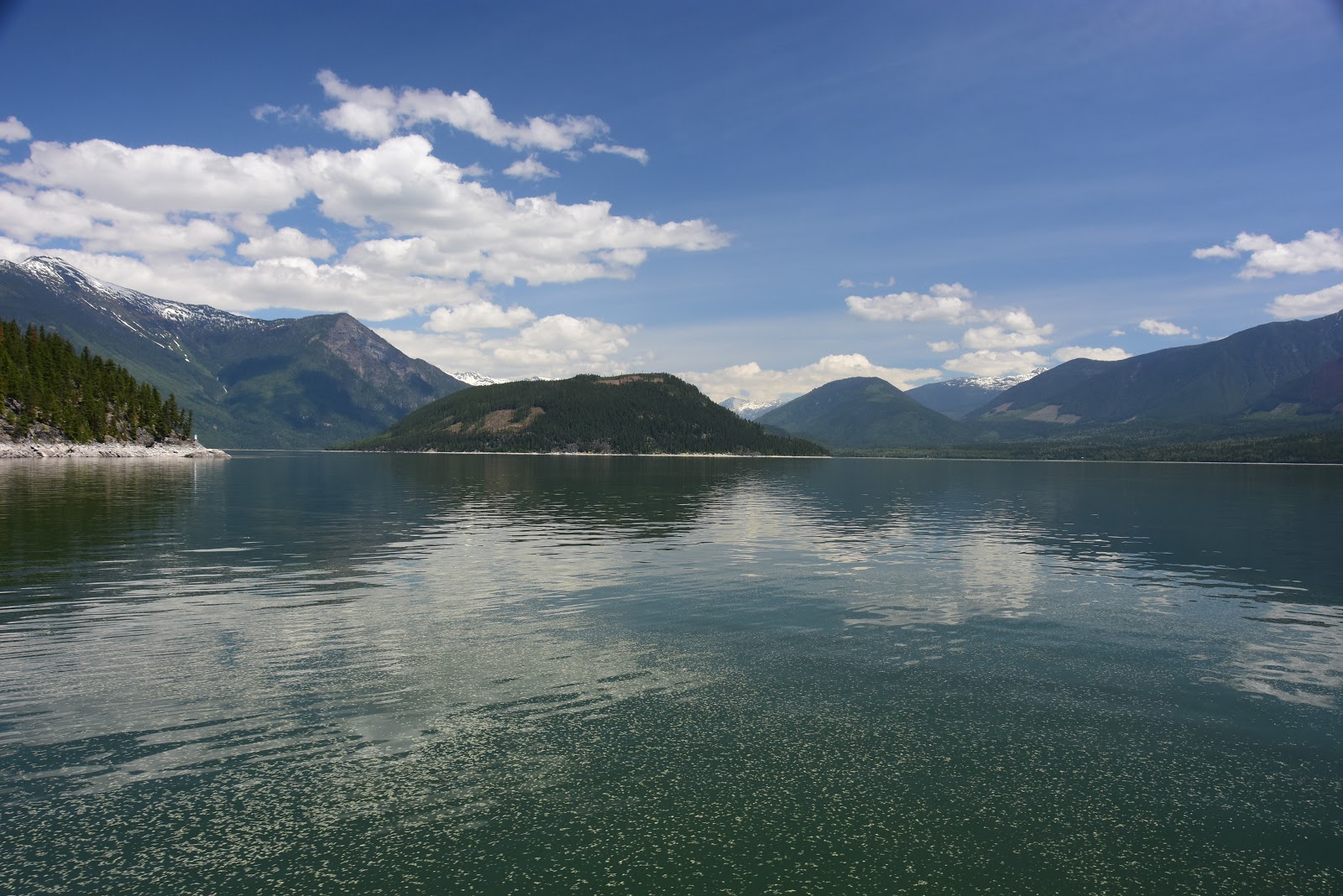
The grounds were just charming. And located as it was just to the east of a magnificent lake surrounded by mountain peaks, it felt like we were touring in Switzerland instead of Canada. All the buildings were an eye-catching white with red roofs, which caused them to stand out spectacularly against the azure sky of the Canadian Rockies.

After visiting the Hotel grounds, we visited the souvenir shop looking for that hard-to-resist gift or personal treasure. Naturally, I came away with my usual “been there, seen that t-shirt,” this one with a railroad subject, which was about the only one I could find in my size and favorite fabric. The T says, “Canadian Pacific, the Golden Age of Travel.”

On our way back to the rig, we did stop again and visit with the old guys showing off their restored tractors, small engines, and such. We met a guy named Bob, who told us he had been an aeronautical engineer for Boeing, but had been retired for the past 26 years. Now he spends most of his time just “restoring things.” He’s the guy with the tractor, which he restored.

Back on the Trans Canadian Route 1, we very soon came upon the fork in the road where we had to head straight ahead toward Golden and Calgary, or turn right and take Route 23 to the ferry crossing. I was sort of hoping Concetta wouldn’t notice, but of course she did. I hadn’t even finished the turn and she said, “Going to Nelson, I see.”

Oh, well, the cat was out of the bag. I had to fess up and tell her that I just HAD to see Nelson. Thankfully, she gracefully acquiesced and before long we were pulling up in line to board the ferry. No ferry was present, so I did some scouting around and talked to one of the other folks waiting in line, too. He told me that the ferry would arrive about noon, load up, and then make the 22-minute dash to the other side of the lake.

We were naturally a little bit uncertain about whether they would welcome a 32-foot motor home with open arms, and we went on thinking that right up until the ferry landed and immediately disgorged no less than FIVE 18-wheelers and a whole bunch of other traffic! Okay, well that put that bit of uncertainty to rest.

For anyone who has never been to British Columbia, you are missing one of the great experiences in life. The whole place (not counting the big cities) is like one big park. Huge peaks, tranquil lakes, raging mountain streams, blue skies – they have it all in doses that have been purely astounding us. The two-lane roads are well kept and smooth, and the beautiful scenery crowds in on both sides.

Speaking of roads, here is the one subject that got me into a bit of trouble today. While we were on the ferry I overheard one of a group of motorcyclists telling another group that there were two ways to head toward Nelson. One was Route 23 on which we had arrived at the ferry, and one was Route 31 which, he said, was more scenic, and ran largely by the lake where we had crossed on the ferry.

Remembering that bit of information as we motored off the ferry and down the road, I naturally chose Route 31 when we got to the fork after lunch. Enthusiastically, we headed off into the woods and were basically the ONLY traffic to do so. Of course we didn’t see the motorcyclists as we had stopped before reaching the fork and had lunch at the top of a runaway truck ramp. You might think that a runaway truck ramp was a darn strange place to have lunch, but when you think about the fact that it was at the very top of a long incline, and afforded terrific views without any traffic, you can see why I chose it.

Anyway, so here we are, heading off into the forest without another sole to keep us company. No one came up behind wanting to pass, and no one drove by in the opposite direction. After about forty-five minutes of smooth sailing on the vacant highway, we suddenly left the tarmac and began rolling on hard-packed dirt and gravel. Concetta and I looked at each other, both of us wondering if this was just a stretch they were in the process of repairing, or what?

After rolling along for another 15 minutes on the dirt road, with the dishes rattling in the cupboards, we came across a farmstead between us and a small lake. Well, I wheeled around and drove right into their driveway. The husband was working on his car as we approached.

I got out of the truck and walked over to where the guy was working, and was about halfway there when the guy’s wife yelled at me from the house to drive slower next time, because I got dust on her newly-washed laundry. Oops! Anyway, so I questioned the guy about just how much dirt road I could expect before getting to the next town, which happened to be Kaslo.

”Well,” he said, “it’s dirt all the way to Kaslo. About fifty miles.”

I was dumbfounded. Surely the motorcyclists had not gone this way at all. “Is it hard-packed and smooth like the last part we drove?”

The guy kinda looked at me, then at the road, then back at me. “Well,” he said, “mostly. Some rough parts, but you know the logging trucks use that road.”

Oh great, I thought. Now I have to choose to go back for over an hour and take Route 23, or we have to endure 50 miles of dirt road. But hey, I thought, the dirt road was better than some of the paved roads in Nevada. Maybe we'll just give it a try. “Okay, thanks,” I said, and retraced my path to the rig – but not before asking him to apologize to his wife for the dusty entrance.

And so on we went, wondering all the time if there was any way that those motorcyclists had come this way. Little by little the road started to get rougher and narrower, until at times we traversed sections where two large vehicles would not have been able to pass at all. Narrow, blind corners came came at us aplenty. In some places flooding had narrowed the road even further.

Around every single corner I fully expected to have to slam on the breaks to avoid being crushed by an oncoming logging truck. We hadn’t seen any so far, and fervently hoped that all the loggers were off on Saturdays and sitting in a roadhouse somewhere, but that didn’t mean we wouldn’t see one around the next bend.

Thankfully, holding our breaths for a couple of hours straight must have done the trick, because we never did encounter a logging truck. We did encounter a couple of young deer who darted across the road in front of us, and at one point a bear cub came up to the road edge to say hello.

Finally, after we had been on the dirt road for what seemed like an eternity, we started to run across other humans. First a pickup truck rolled past us going the other way, thankfully on a nice wide portion of the road. Next we ran across a whole crowd of people who had stopped to enjoy a spot where a dam and bridge lay across the river, above which we had been traveling for so long.

At the bridge, we stopped as well to do some walking and to let the brakes cool off on the rig, which I had been smelling for quite a while. From that point it was still going to be another 15 miles or so of dirt road, but by then we were old hands at logging-road bushwhacking and just sat back, exhaled, and enjoyed the rest of the ride.

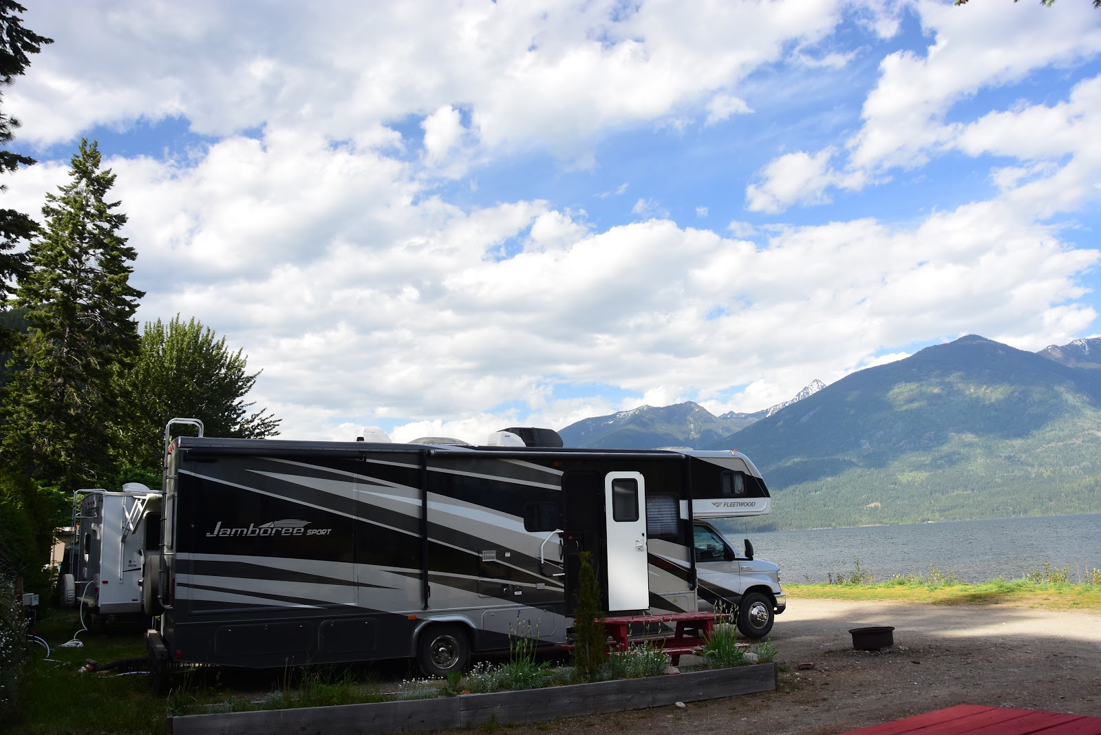
Eventually, we were able to find a camp about an hour’s drive north of Nelson and succeeded in snagging a terrific spot right on the shore of Kootenay lake. The second half of our day was pretty nerve-racking and tedious, but in the end all’s well that ends well. We have a couple of great neighbors here, tomorrow promises to be bright and sunny for our sojourn around Nelson, and I can’t think of anyplace else I’d rather be right now.

And when you get ready to hit the road, and you set out on your quest for adventure, we wish you exciting destinations and memorable travels from the Davises, the Happy Wanderers.

Day 15 - Oliver to Sicamous, British Columbia - 143 Miles

Sorry to say no service to speak of in the mountains of British Columbia at present, and may continue through tomorrow.

Thursday, May 24, 2018

Day 14 - Omak, Washington to Oliver, British Columbia - 56 Miles

Well, we certainly thought when we started out from Carson City that the further north we drove, the cooler it would eventually become. In anticipation, we brought all manner of winter-ish hats, coats, and gloves. But au contraire, mon ami! It seems that the warm temperatures have been following us north. Good thing we're not headed for Alaska, or we'd probably bring about the premature melting of the Alaskan tundra.

So how warm is it, you say? Well, the temperature appears to be just over ninety, both inside the rig and outside in one of the lockers where I keep a sensor. So far we've been toughing it out, and have not cranked up the air conditioner. But this afternoon, after we had quietly slipped over the border into British Columbia, presented our passports, and traveled just a few miles north, we realized that we were NOT going to be encountering Alaska-like temperatures anytime soon. It might be Canada, but it felt like Las Vegas.

Nevertheless, once we had located a camp just three miles off our intended route north, we motored over there, got set up and, once done, we grabbed the camera and wandered off to explore our environment. We're camped close to Tucelnuit Lake, well, close enough to walk to it, and the camp does enjoy some cool breezes because of the spring-fed lake water. Sitting lakeside watching the sun begin to set was great.

But once we hiked back to our camp on the outer fringe of the grounds where they keep the "one-night-only" guests, and we were no longer enjoying those lake breezes, we decided that tonight was the night to crank up the air conditioner. We tried to conserve energy, but if Canada refuses to live up to our expectations and be fricking cold, well it's just their fault.

Once again you're no doubt wondering how we can travel a measly 56 miles in one entire day. Well, this morning we did get out of camp at a decently early hour, but we had to backtrack the six miles to the nearest town to take care of some essentials: first, the propane was down to a quarter tank so we had to get a refill; second, the rig needed an infusion of gasoline, and third, we had to drop by the ubiquitous Wally World to stock up on groceries.

By the time those chores were accomplished, it was past ten in the morning before we were ready to roll on northward. For the balance of the morning we traveled highway 97, eventually crossing into Canada. Next, we stopped by the visitors center in the first town we came to, one improbably named, "Osoyoos," before scouting out a place for lunch.

While in the process of getting the rig positioned off the side of a rural route west of downtown Osoyoos, I happened to notice a very large tan building with the words, "Desert Model Railroad" inscribed thereon. Figuring that any such activity would probably only be staffed on weekends, I dismissed it as a potential activity for the afternoon.

But once lunch was finished, I decided to at least drive by the big tan building to check for any signs of life. This we did as it lay just across the highway from where we had eaten. Much to our surprise, though there was only one car in the parking lot, the model railroad appeared to be open for business. Since I had been looking for some sort of activity all day that I might write about in the blog, I went ahead and parked outside.

I suspected that Concetta was not going to be entirely gung ho on the idea of model railroads, but hey, we hadn't stopped at any attractions all day, and this one was a bird in the hand.

Much to our surprise the whole appearance from the moment we entered the building was one of extreme professionalism and attention to detail. You initially enter a gift shop where you purchase your tickets, and the shop was excellently laid out and appointed. But once you have paid, you ascend a flight of stairs and enter a world that you would NEVER have been able to imagine in a million years. And that's before we learned that only FOUR individuals, two men and two women, performed ALL the work on the giant indoor railroad.

I had never seen such a feat of modeling in my entire life. The room, which probably measured forty feet by eighty feet, was absolutely jammed with spectacularly crafted models, both animated and non-animated. All the models were behind glass, but the glass was kept scrupulously clean, and it did not provide the slightest impediment to viewing the trains and miniature city-scapes, rail-lines, and upwards of 16,000 individually-painted figures.

We were totally entranced by the miniature world before us. Computer-operated trains chugged away in two dozen different places on the huge layout. Here and there, light rail cars dashed through center cities, mining operations took place underground, and other animated scenes like circuses and emergency rescues, all operated autonomously as if by magic.

I didn't expect Concetta to become so immersed in the miniature world, but when I looked over she was busily filming the activities with her Iphone. At one point the computer called for nighttime lighting, and slowly the illumination in the room fell off until only the various street lamps, train headlights, and building window lights illuminated the scenes.

And here's the incredible part: the whole model empire is built entirely with German Marklin trains and other non USA components. Their brochure proclaims that the layout is North America's largest Marklin (German) train layout. I know I've NEVER seen a larger one anywhere, and all of the streetscapes, woodlands, and mountains look remarkably European! Absolutely amazing!

After visiting the fantastic model railroad, and we were again headed north on Route 97, I decided that I just had to find a spot on a hill somewhere and get a shot of the beautiful agricultural lands that had been passing by our windows for miles. So as we approached some tiny rural lane headed toward just such a hill, I flipped a right turn and went adventuring. The lane was pretty narrow, and we weren't real sure we'd have room to turn around once we got to the top, but we forged ahead anyway. Thankfully, once we'd gone as far as we could go, and had to turn back, I was able to reverse the rig into someone's side yard and head back the way we'd come. And that's how we got some nice shots of the valley and all its greenery.

After that, it was getting on toward cocktail hour, so when we'd gone just a few more miles and we came across a road sign that promised a nice camp just three miles off the highway, we took the chance and made the turn. As it happens, our spot is a tad too close to the noisy local thoroughfare for our tastes, but I imagine it will quiet down toward nightfall. Other than that, the camp is terrific, the setting beautiful, and the price reasonable. The owner here, a chap named Gary, is a one-time owner of a huge camp located on Vancouver Island that sported 180 spaces. Thinking he wanted to retire, he sold it, but then realized that he was bored. So he bought this charming little place beside Lake Tucelnuit that has only about fifty spaces. Now he's happily staying more active. Perhaps his experience is a good one to keep in mind for all of us. Relaxation is great, but never try to make it your sole goal in life.

And with that bit of worldly advice, I will sign off and go turn off the darn air conditioner. It's just getting too cold in here now. And when YOU go looking for cooler -- or hotter -- temperatures in your quest for adventure, we wish you exciting destinations and memorable travels from the Davises, the Happy Wanderers.

Wednesday, May 23, 2018

Day 13 - Leavenworth to Omak, Washington - 175 Miles

Today turned out to be quite unusual for a number of reasons. First of all, as I mentioned in the blog yesterday, the KOA where we stayed last night has been undergoing a full refurbishment this spring. This meant that as we pulled in we had to thread our way between a small army of big-rig dump trucks, seriously large tractors, and multitudes of guys busily spreading and raking and smoothing the drive area with hand tools before the asphalt spreader arrived in the morning.

Concetta and I just KNEW that if we trusted the camp employees when they told us that we'd be able to get out in the morning, even though the spreader would be throwing down asphalt nearly everywhere, we would probably be stuck until the work was done. Hence we'd spend the entire day "hanging out," doing not much, and enjoying the aromatic scent of warm asphalt as it enveloped the camp.

So you know what we did I imagine: we got up at 5:00 a.m., rushed through breakfast and stowing of all the connection equipment, and then rolled through the front gate around 7:00 a.m. Hence, even though they were warming up the asphalt spreader and all the workers were feverishly maneuvering trucks, doing last-minute "smoothing" of things, and generally looking like they were going to let nothing stand in their way of laying asphalt this morning, we'd didn't let the door hit us in the ass as we slipped out. I did wonder about the Alaska-bound guy, who checked in just ahead of us yesterday afternoon, who told them he'd be ready to roll at 11:00 a.m., and they told him no problem. I just bet even money that he DID have a problem and probably had to stay anther night.

Anyway, this put us on the highway 2 1/2 hours before our usual camp exit time, so we had lots of time to laze along and see all the sights. After gasing up in Leavenworth, we jumped on Route 2 and headed east toward the Washington town of Wenatchee. There we intended to catch Rote 97 north toward one of the most impressive, man-made structures in the country, the Grand Coulee Dam.

Route 2, as you might expect if you study a map, is not exactly a heavily-used highway. Since we ALWAYS avoid the "Blue Highways," the Interstates, Route 2 is just the type of rural road for which we search. Nor were we disappointed, as we got to see miles of verdant, rolling farm land, the occasional rural hamlet now going to seed, and even some great roadside geology.

Once we reached Wenatchee, we turned north onto Route 97 and proceeded to thoroughly enjoy a great morning motoring beside the outflow stream from the Chelan dam some thirty miles to the north of us. Here the acreage was largely being used for orchards of several fruit varieties. All the fruit stands we passed were closed, of course, but we bet that come late summer some mighty fine fruit would be available on this stretch of Route 97.

Once we reached the town of Orondo, it was time to leave Route 97, climb out of the river canyon via a steeply twisting road, and then head further east toward the city of Coulee, which lies next to the Dry Falls Dam that holds back the body of water named Banks Lake. Banks Lake, as we would later learn on our tour of the Grand Coulee Dam, is entirely man-made and draws its water directly from Grand Coulee. The Lake was formed by damming the northern 27 miles of the Grand Coulee, and has an active storage capacity of 715,000 acre-feet. I believe our guide told us that over 400,000 acres are also irrigated by Banks Lake.

After stopping and photographing Banks Lake, we loaded up and headed still further north on Route 155 for our eventual rendezvous with America's biggest, most impressive dam, the Grand Coulee. We arrived at the visitors center right around 11:00 a.m. with the intention of learning about the dam, then taking lunch in the parking lot, after which we'd be on our way. But the staff at the visitor center immediately put the ca-bosh on that idea when they suggested that if we just got to the proper parking lot on the other side of the Columbia river, and at the proper hour, we could conceivably get a tour of the facility itself.

Okay, so we dashed back to the rig, fired her up, then headed several miles down the road and across the mightly Columbia River for a chance at getting the tour. At the visitor center they told us it was a first-come, first-served type of affair and we should not tarry.

We got there just in time to discover that no one else but us had arrived for the tour. Not even the guides were in residence. Alright, we said, move to plan B. We hurriedly prepared lunch, got it eaten and cleaned up, and by then people were starting to arrive, guides and guests alike. So, we locked up the rig and quickly joined the thankfully small group and succeeded in getting a place on the tour.

Some facts on the Grand Coulee Dam: it's operated by the Bureau of Reclamation, and was part of FDR's "New Deal" program back around 1933. The New Deal was designed to use the vast army of unemployed labor, who had been affected by the Great Depression, for constructing anything and everything that the country might need in the way of infrastructure. Projects great and small were done this way; the dam capable of producing 6,809 Megawatts of electricity, or over three times the capability of the Hoover Dam; they used 11,975,521 cubic yards of concrete, or three times that of the Hoover; and it provides power for eleven western states as well as Canada!

We were just a bit disappointed with the tour, since when certain construction projects are under way, you don't get to go down in the dam, or walk across the top. That would have been an unbeatable opportunity, but today the answer was "Sorry!"

Once the tour was over, our next goal for the day was a visit to the memorial for the almost mythic figure of Chief Joseph of the Nez Perce tribe. Chief Joseph and his people were among the last to be forced onto reservations and his story is nothing short of phenomenal. You can check out a short bio at: http://www.pbs.org/weta/thewest/people/a_c/chiefjoseph.htm (Sorry, I can't seem to make link work correctly)

Since the supposed memorial was just up the road from the Grand Coulee, we thought it certainly warranted a look-see. Unfortunately, when we arrived at the wide spot in the road that had been allotted to his memory, it turned out to be just a "Rest Stop" sporting a couple of placards explaining his history. The site did have some cool sculptures which added a bit of class I guess.

At first we stopped opposite some tribal members, who happened to be sitting in an abandoned gas station beside the highway chatting, and asked them if they would direct us to his grave site. They sort of looked at each other questioningly, probably uncertain whether to send us and our 32-foot rig off the paved highway and up a steep dirt road toward the cemetery. But finally they sighed and directed us to the proper route and advised me that we'd probably have to walk the last bit as the RV might be a bit large to maneuver up there on cemetery hill.

But as we got close we came upon another couple of tourists who were looking for exactly the same grave. The two gentlemen and I discussed the fact that they had been unable to locate it, and perhaps the Roadside Rest would be our best bet for learning about Joseph.

I was disappointed that there was no grand memorial, but meeting the two other tourists turned out to be quite a lucky break. The one guy who did most of the talking, Gene Scrivner from Burns, Oregon, is an avid American Indian historian, Oregon Trail historian, and all around American History "nut!" Boy, did he and I fly into a barrage of "history talk" in the few minutes we were together. In the end, I gave him one of our cards, and told him if he ever needed, for instance, a photo done of some historic place in our Nevada, area I'd be happy to oblige him.

There are many and varied lessons to be learned when you're on the road, but a great one is to never, ever be too shy to approach someone for information. I suspect that I will someday hear from Gene again, and maybe someday we'll be able to sit over a cup of coffee and discuss historic subjects to our heart's content. I'd sure like that.

After leaving the Chief Joseph Rest Stop Memorial, we continued north and west on Route 155 toward its junction with Route 97 and the town of Omak. In Omak we expected to find a nice, tranquil camp beside an open field where we could spend the night. And surprise, surprise, that's exactly what we found. We did have to spend a half hour driving in pretty enthusiastic rain, but in the end the sun came out, the GPS tried no shenanigans, and we rolled into Glenwood Camp north of Omak right around cocktail hour to secure the sole remaining space for the night.

So here I sit, tapping away, while Concetta reads her book in the back bedroom. The sky is wonderfully blue, the clouds have been voluminous and fluffy all day, and perhaps we'll get a great sunset as an added bonus. Tomorrow we're headed further up Route 97 until it stumbles into British Columbia, our oft discussed destination for this trip. I rather think that there will be still more changes to our itinerary, but until then we wish YOU exciting destinations and memorable travels from the Davises, the Happy Wanderers.

Tuesday, May 22, 2018

Day 12 - Sultan to Leavenworth Washington - 81 Miles

As you can see from the mileage, we didn't push it very hard today. We slept in until 7:30 since we read late into the night, then lazed our way through breakfast until mid morning. About 10:30 we started up the rig and headed for the camp exit. Sorry I didn't take any photos of the Thousand Trails facility were we stayed. I thought it was just okay, and nothing to write home about. PLUS, most of the spots were taken by permanent residents, which makes the stay a whole lot less enjoyable since you don't run into fellow travelers to BS with.

The Thousand Trails camp, called the Thunderbird Resort, was only about 3 miles off our intended route, so it was a quick jaunt back to Sultan, then onto Route 2 to continue our sojourn east toward Wenatchee, Washington. We don't have any particular reason to go to Wenatchee, just thought Route 2 would be pretty as it involved climbing a fairly low pass of 4,000 plus feet, and running beside the Skykomish river much of the way toward the pass.

We'd only traveled about an hour when I pulled of the highway and into a rustic camp in hopes of getting some photographs of the Skykomish rapids which were tantalizingly close as we wended our way along Route 2. Concetta told me it was too early for lunch and she wasn't hungry yet, so I grabbed the camera and headed toward the river to get some shots. The camp in which we had stopped was almost devoid of campers except for on one space. Even the camp host was absent. So I spent the next half hour photographing the river, the forest, and even the nearby Railroad. Just everything was so peaceful and beautiful that I was gone for a good forty-five minutes before Concetta called me and "suggested" that I get back to the rig for lunch.

As it turned out, While I was gone Concetta had a visitor who had been tasked with delivering a load of wood and wasn't sure he could navigate around our RV to make his delivery. Good thing he decided to move on and visit the camp after he'd made a few more deliveries.

Once back at the RV I found that Concetta had lunch ready so we spent another forty-five minutes doing lunch. By the time we left the camp and jumped back on Route 2 it was near 1:00 p.m. and we still had sixty some odd miles to go before we reached Wenatchee.

Of course I stopped one more time to shoot the rapids before we started up the final leg leading to the summit, and we HAD to stop on the summit and tour the ski resort there when we had attained that milestone. So by the time we rolled into Leavenworth at 3:00 p.m. and then shortly thereafter saw the sign for the nearby KOA, we decided that Wenatchee would have to wait until tomorrow and we just took the turnoff and pulled into the KOA for the night and called it good. Such is the life of retired folks who care little whether they make many miles or not.

The downside to this KOA, we found once we'd pulled into the checkin lot, is that they're are planning to blacktop a bunch of stuff tomorrow and so a myriad of tractors, rollers, and guys with tampers and rakes are busily -- and noisily -- going about their leveling business before the paving festivities tomorrow. Thankfully, about 5:30 p.m., the paving guys called it a day, and now the sound we hear is coming from the nearby Wenatchee River as it cascades its way through the narrow canyon below us.

The beauty of this KOA camp in Leavenworth is that it appears that someone has recently purchased it and fully intends to bring every single facet of the operation up to snuff. The sites have been leveled, a new pool has been added, all the buildings have received new siding, a new coffee bar has been constructed, and come tomorrow, the whole dang place will get blacktop on all the major roads. The place should certainly be a camper's dream-come-true by this time tomorrow.

The best part about the camp is that there is a wonderful trail down to the river with a great picnic lawn area halfway down if you want to bring a blanket and have a midday feast among the towering pines. If not, you can continue on down and soon find yourself right on the Wenatchee River with a terrific landscape of massive boulders, white water, and wildflowers to keep you company. The trail is not steep, and it's so wide and smooth that one has no problem with the short 200-yard hike.

And there you have it. We've had our cocktails (which is making it a bit hard to spell correctly right now), Concetta has popped a load of laundry in the washer in the main building, and soon we're going to be tucking into a plate of good ol' homemade stew that Concetta froze and brought from home. I'm not sure how life could get any better. Tomorrow we're headed....well, we don't yet know where exactly that is. We just hope we find something interesting to tell you about. And when YOU can hit the open road and fulfill your dreams, we wish you exciting destinations and memorable travels from the Davises, the Happy Wanderers.

Monday, May 21, 2018

Day 10 - Kent to Sultan, Washington - 60 Miles

Probably the first thing you're going to ask is how ANY RVers worth their salt manage to travel only sixty miles in one entire day? Well, it's simple: it's the fault of the Internet. When we got up this morning, I was intent on penning at least a few lines on yesterday's blog since I had arrived back at the camp much too late to start Sunday's narrative. But when I tried to connect, the mobile device was indicating only 38% reception, and I was having no luck connecting to anything; no email, no Facebook, and certainly no blog editor.

So, what to do. I knew that we were headed into the mountains and there was good chance that we would continue to have connection problems in our afternoon camp somewhere east of Seattle. In addition, Verizon has been warning us for several days that we were close to using up ALL of our month's data, and the month wouldn't be over until mid June. Now THAT'S a bigger problem than reception. No data capacity means no photographs for the blog.

We decided that the only answer, since I could not go online to boost our allowable data supply, was to seek out a Verizon store and let them do it for us. We easily found a Verizon store quite near us, 8/10s of a mile I think it said on the screen. But when we got to the supposed site, there was nothing at that address but an empty building. So we chose another Verizon store that unfortunately was six or eight miles away. This we found without difficulty.

When I presented myself at the Verizon counter it was my great fortune to have the manager, a chap named Lawrence, offer to help me. After discussing my need for more data, Lawrence suggested that I should change over to "unlimited data" while we were RVing so that we wouldn't have to go through the task of upping the data again if we guessed wrong on our future data requirements. I thought that sounded like a great deal, and told him to make it so.

While we were chatting about data, I brought up the subject of perhaps acquiring a new Jet Pack, which is our mobile device that we always use on trips. We have our own mobile device because the Internet at the majority of RV camps is quite overloaded and slow. Having your own Internet means only two of you are using it, which is just lovely.

Anyway, I asked Lawrence if he would recommend the newest version of the Jet Pack and he told me he definitely would, since the new ones are 5G ready. Plus, he said, he could make me a super deal on the new one that I would just not be able to turn down. Well, Lawrence was true to his word, and we now have the latest Jet Pack onboard, which sure seems to be faster than the old one.

Also, while we were at the Verizon store, Concetta complained to Lawrence about how her iPad just doesn't seem to want to attach to the Internet since we've been on vacation. Lawrence happily tested her device against the store Internet, as well as our new Jet Pack, and discovered that the usually reliable device had indeed quit working. Lawrence suggested that he'd make her a super deal on that device as well, and Concetta now has an iPad that works perfectly.

As you might guess, our travel time was ticking away as all this was going on, but we weren't done. During our conversations with Lawrence we grew quite fond of him. We were sharing everything from family photos to stories of our work histories. At one point he asked me what my email was, and I gave him the "writeguy47" address. He asked me if I was a writer. I told him that I had chosen the email address while I was in the middle of writing a murder mystery.

"Wow!" Lawrence said, "Really? I write mysteries, too?"

Now we began to really get acquainted. I gave him a copy of my mystery, and he gave me a copy of each one of his two published works. We traded contact information, and promised to keep up with each other, and I really think we will. Lawrence is a super guy, headed for wild success I suspect, and I wish him the very best of luck in his future endeavors, whatever they may be. So, if you happen to stop into the Verizon store in Auburn, Washington, tell Lawrence I sent you. He'll definitely take great care of you, and you'll probably make another friend as well.

Naturally, after all this palavering and getting to know Lawrence, our potential travel time had dwindled to half a day. No reason to move until we had lunch, which we did in the Verizon parking lot. So by the time we got rolling again it was 1:00 p.m.

Our intended goal for the night was a camp along Route 2 going east out of Seattle, which we accomplished without difficulty. Well, we didn't have any difficulty until we got to the camp, 9 miles south of the town of Sultan, along Route 2. There we discovered that it was a Thousand Trails camp and it was only with a great deal of difficulty that we were able to sign up on line, pay our fee, and then gain access. Good thing we got here when we did, as they only had two spaces free for the evening.

The last thing I'll tell you about is the terrific frescoes that we ran across in the town of Sultan (all photos save that of Lawrence are Sultan). I don't imagine that more than a couple of thousand people live around the town, but they truly have some wonderful fresco artists. So now we're set up beneath a huge canopy of trees, on a not quite level space, with a crashing dumpster lid that seems to resound throughout the camp every few minutes nearby. But as we finish dinner and things have quieted down, I think we'll be fine here for the night. Tomorrow we're headed east again, we're not entirely sure to where, but until tomorrow, we wish you exciting destinations and memorable travels from the Davises, the Happy Wanderers.

Day 9 - All day in Seattle and Brainbridge Island - 15,000 Steps

On two of our vacations in the past we fully intended to visit Seattle. The first time, in the early 1980s when our vacations were more limited by employment, we simply ran out of time and had to return home. The second time, which happened to be our very first RV trip together in 2013, we simply decided that we wanted to see more trees and free-running streams, and less traffic congestion and hustle-bustle, and so we opted to bypass Seattle in favor of Glacier National Park in Montana.

But the third time was the charm and we finally made it. Or at least we made it as far into the city proper as we were prepared to take our 32-foot home on wheels. We ended up staying at the KOA in Kent, Washington, which is conveniently located on a major bus line to take adventurous RVers into the "big city."

A word about the KOA in Kent if you plan on staying someday. First the negatives: it's a pretty crowded park with rigs parked about every twelve feet or so from each other; the lanes between rows are somewhat narrow if you have a really big rig, though I did see a few; the laundry room is okay, but not containing very up-to-date machines.

On the positive side: the proximity to the bus line is terrific as it stops right outside the camp entrance and the buses run really late should you want to have dinner in Seattle one night; it's pretty easy to find off the north/south freeway, and the avenues are wide as you approach; and the grocery and supplies store is pretty well stocked for all your needs, both essentials and knickknacks.

So, since the bus line was right at our door, we took advantage, along with another older couple from the park, and rode into a transportation center called "SeaTac." At SeaTac you can leave your bus and board the light rail for a trip north into the heart of Seattle. The train was very nice, looked pretty darn clean, and the passengers were friendly and helpful if you needed directions. We disembarked at the stop called "Pioneer Station" and were able to walk about two blocks and be right on the waterfront where the ferries load for transportation to points west like Vashon, Bainbridge, and Bremerton.

From where we were standing, you could not get a ferry to Vashon, our original destination, because the ferry only ran on weekdays. But we could have gone to either Bainbridge or Bremerton. We chose Bainbridge, and so for the princely sum of $3.00 each we were treated to a 45-minute, smooth-as-glass ride across the bay to our destination, as well as the ride back to the mainland at the end of the day.

As we walked from the light rail station to the docks area, we stumbled on the perfect lunch stop in the form of Luigi's Italian Eatery and Cantina. We were a tad early, so ended up having the entire restaurant -- and Beth, our waitress -- to ourselves. The address was 621 First Street and is just a short distance north of your direct path from light rail entrance to the nearby ferry piers. Beth really rolled out the red carpet for us, served a truly heavenly dish of gnocci and shrimp in an alfredo sauce, and furnished us with a couple of very nice salads. Concetta had some Pinot Grigio, but I stuck with the ice tea, as I didn't want to get too relaxed and forget how to get back to our home base later on.

Now it's possible that if we had disembarked from the light rail two or three stops before we did, we might have been able to catch another ferry for Vashon Island, even though it was Sunday, but I have not done any research on that. As it was, we were perfectly thrilled with our choice of islands. We spent the whole day, which thankfully was sunny and warm, walking all around the commercial district, and waterfront.

The small museum on Bainbridge is quite interesting, and specializes in displays surrounding the topic of the effects of World War II on the Japanese who lived on the island at that time. Concetta and I both thought the displays and the accompanying video were well done. As an added feature, depending on the day you arrive, a couple of the museum docents are actually current Bainbridge residents of Japanese descent who personally spent some time in the Manzanar Relocation Camp in the Owens Valley of California.

Naturally, we spent a big part of the 15,000 steps we accumulated on the island looking around for a neat place to have dinner. We had a couple of recommendations, one of which was Doc's Marina Grill on the bay. We ended up choosing Doc's. I had the fish and chips and thought the food was okay, but Concetta was a little harder to please and didn't think her fish was as good as it could be.

The other place recommended to us was right on Winslow Street and was called Nona's, if I remember correctly. If we were to go back, we'd probably choose Nona's. Still, I will put in a good word for Doc's. The flan was very nice and light, and our perky teenage waitress was nice as pie, and gave us great service.

About 4:00 p.m., as we were headed down Madison Street to check out Doc's, we stumbled over a quintet of musicians on the "Village Green" and sat and listened to them for a good half hour or more. They were a little rough, but they obviously had played together in the past and appeared to know all the songs. Their music wandered anywhere from blue grass to blues, and turned out to be one of the high points of the day.

When we finally reached the yacht harbor next to Doc's Marina Grill, I was overjoyed to see that the waning sun was doing some marvelous things to the boats in the harbor. Ever since I served as a crewman on a sixty-foot yacht back in summers of 1973 and 1974, I've been pretty enamored with shooting any kind of boat. And yacht harbors and docks full of those glistening craft, not to mention the ambient smells of all things nautical, really brings back some fond memories for me. At one point I even wandered into the adjacent chandler's shop just to hang out with their stock of sailing books, nylon lines, stainless-steel hardware, and captain's hats that said "Old Salt" on them.

With dinner over we retraced our steps back to the ferry just in time to board for the return trip. The ferry was not at all full for the 6:30 trip, so we could sit pretty much anywhere we wanted. We chose to cruise back on the top observation deck and enjoy the sea breezes. The wind got a little stiff at one point, but the view, both of the boats going by in the bay, and the ever nearer skyscrapers of Seattle, was not to be missed.

If you happen to repeat our sojourn from the Kent KOA to one of the islands and back, be sure to leave yourself enough time for each leg of the journey. Going out it's not so important, but coming back you could run quite late if you're not careful. We left Bainbridge Island around 6:30 and didn't arrive back at our RV until almost 9:00 p.m.

And now a word of explanation. Since we got back so late there simply wasn't time for doing the blog. I apologize, but it just couldn't be helped. So if you're reading this now, keep in mind it's for Sunday, May 20th. Today we had some great times of an unusual nature, but that's for the next day's blog, which is today, and I intend to get right to work on. So until next time, we wish you exciting destinations and memorable travels from the Davises, the Happy Wanderers.