

There is nothing on earth that smells as wonderful as the ubiquitous high desert sage plant after a rain. I'm proposing this because right now we're holed up in Rawlins, Wyoming for the night, it's been raining off and on since 4:00 p.m., and when I went outside wearing my rain slicker to attach the electrical cable and water hose, the sweet, familiar scent of sage flowed over me like a olfactory tidal wave. I loved it!
For the better part of the day, we enjoyed a traditional double-dose of Wyoming sunshine. From our camp yesterday in Douglas, Wyoming, we headed up Interstate 25 until we reached the historic town of Casper about fifty miles to the northwest. Initially our plan had been to visit historic Fort "Caspar" (same guy, different spelling. But as we approached Casper, we saw a sign for the "National Historic Trails Interpretive Center." I hadn't realized that such an attraction was available, and we immediately changed our plans. We've been to the Trails Interpretive Center in Elko, Nevada, and found it to be wonderful. We were excited to see Wyoming's contribution on the topic.
According to the Interpretive Center flyer, between 1840 and 1870 about 400,000 people moved across the western plains in search of free farmland, freedom of religion, wealth, and new business opportunities. They traveled to the Oregon Territory, to the Great Salt Lake Valley, and to the California gold fields. The center tells the pioneers' stories, as well as those of the Native Americans and the Pony Express riders.

Most of the Interpretive Center exhibits are done in the new and modern museum style using interactive components for both adults and accompanying children. You can try pulling a Mormon handcart, packing your wagon for a frontier trip (using models), or ride aboard a ferry like those used in the mid 1800s to help covered wagons across rivers too deep to ford. You could also listen to the voices of the Lakota Sioux as they tell about their tribal origins.
Everything about the museum was first rate, from the audio and visual presentations, to the way many stories were told through "flip books" that allowed visitors to read about individual pioneers. I especially liked their display of a covered wagon that went so far as to identify most of the wagon's components using black and white labels.
The museum sits on a bluff overlooking the emigrant trail as well as the North Platte River that the emigrants were using as their life line as they passed through Wyoming on their way to Oregon. As you stand on the edge of the bluff, and look south upon the modern city, you can almost "feel" those long lines of prairie schooners edging their way west past the bluffs beneath you.

Here's what Wikipedia has to say about the immigrant experience: "The path followed by the Oregon Trail, California Trail and Mormon Trail (collectively referred to as the Emigrant Trail) spans 400 miles through the U.S. state of Wyoming. The trail entered from Nebraska on the eastern border of the state near the present day town of Torrington and exited on the western border near the towns of Cokeville and Afton. An estimated 400,000 settlers traveled on the trail through Wyoming between 1840 and 1870. All three trails follow the same path through most of the state. The Mormon Trail splits at Fort Bridger and enters Utah, while the Oregon and California Trails continue to Idaho."
"In the eastern plains, the Emigrant Trail follows the North Platte River into Wyoming. The trail follows the river upstream to Fort Laramie, a prominent military and trading post in the region. Prior to 1850 the northern side of the river was thought to be impassable beyond Fort Laramie, so the wagon trains that were traveling on the northern side of the river through Nebraska had to undertake a dangerous crossing at the fort. After crossing, trains on the main trail to the south of the river had to cross the North Platte again 100 miles upstream."

"In 1850 several wagon trains successfully blazed a path along the northern side of the river. This new route, which reduced the risk and expense of crossing the river twice, was preferred for all subsequent traffic on the northern side of the river. The northern route is sometimes called Child's Route after Andrew Child who described it in a guide book published in 1852. Above Fort Laramie, Child's Route follows the North Platte River through the present day town of Douglas, and near the site of Fort Fetterman which was built in 1867. This is the point at which the Bozeman Trail turned north to the gold fields of Montana in the 1860s."
"The southern route also follows the river along the edge of the Laramie Mountains to an area near the current towns of Casper and Glenrock. In 1847, during the first Mormon emigration, Brigham Young established a ferry near present day Casper known as Mormon Ferry. The next year the ferry was moved a few miles downriver. The ferry was free for Latter Day Saints, but charged a toll for other users. The ferry was manned by groups of Mormons every summer from 1848 until 1852."
"In 1853 John Baptiste Richard built a toll bridge near the ferry site, which would eventually put all ferries on the North Platte out of business. In 1859, Louis Guinard built the Platte Bridge near the site of the original Mormon Ferry. Guinard also built a trading post at one end of the bridge which eventually became Fort Caspar."

"Continuing upstream from Casper, the North Platte bends to the south. The original trail proceeded several miles along the river to Red Buttes, where a bend in the river formed a natural amphitheater dominated by red cliffs on the hill above. The river was easier to ford here for those who were unwilling or unable to pay to cross using one of the ferries downstream. This was the last good camp spot before leaving the river and entering the water-less stretch between the North Platte and the Sweetwater River."
"From here the settlers entered a difficult portion called Rock Avenue which moved from spring to spring across mostly alkaline soil and steep hills until it reached the Sweetwater River. Later settlers who had crossed to the northern side of the river at Casper would come to favor a route through a small valley called Emigrant Gap which headed directly to Rock Avenue, bypassing Red Buttes."
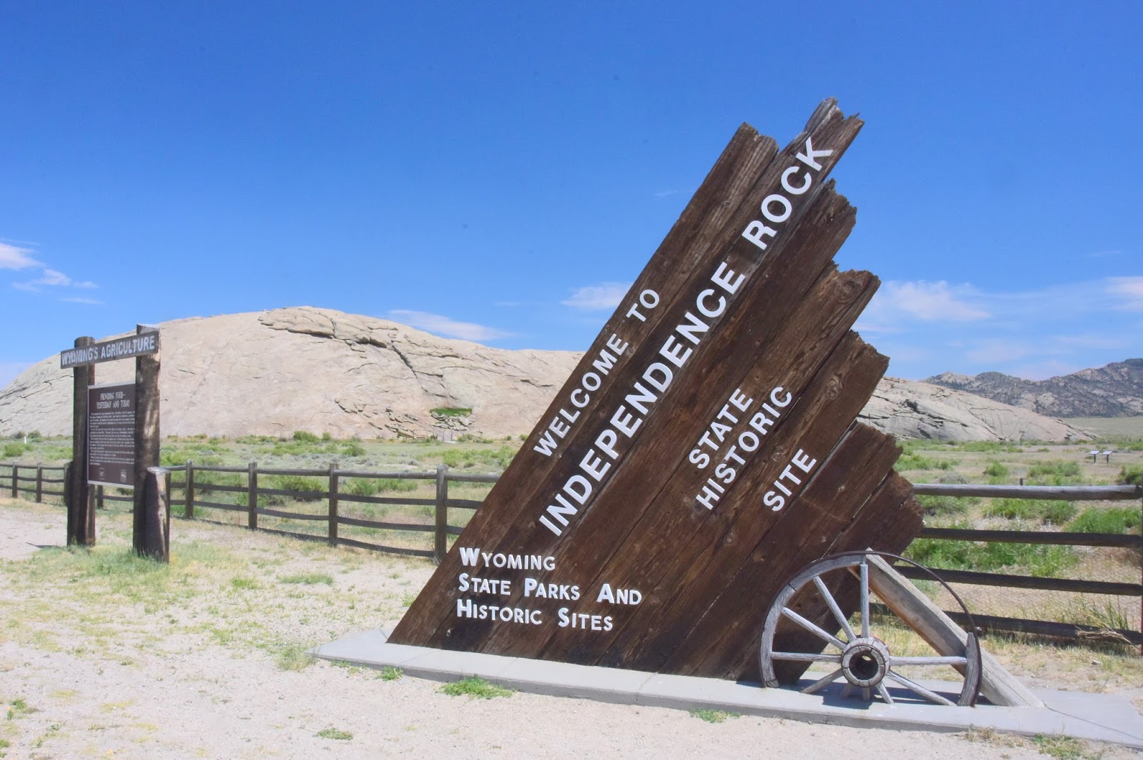
"Upon arrival in the Sweetwater valley, the trail encounters one of the most important landmarks on the trail, Independence Rock. Independence Rock was named because settlers tried to reach it by July 4 (Independence Day) to ensure that they would be at their destinations in California or Oregon before the winter snows came. Many of the travelers left their names on the rock, either carved or painted on with axle grease. It is estimated that more than 50,000 signatures were inscribed on Independence Rock.
We were so fascinated with the quality of the Interpretive Center, that we stayed until nearly lunchtime. But realizing that we had to make some miles before nightfall, we finally had to retrace our steps to the RV, have our lunch, and get on the road.
Still, we had one more stop to make. Though we had to pass several potentially historic and interesting points on the overland trail that lay along Route 220, there was one we felt that we should definitely stop and see: Independence Rock. This famous landmark on the trail, where thousands of emigrants scratched their names, is just a "must see."

Here's what Wikipedia says about Independence Rock: "Independence Rock is a large granite rock, approximately 130 feet high, 1,900 feet long and 850 feet wide, in southwestern Natrona County, Wyoming. During the middle of the 19th century, the rock was a prominent and well-known landmark on the Oregon, Mormon, and California emigrant trails. Many of these emigrants carved their names on the rock, and it was described by early missionary and explorer Father Pierre-Jean De Smet in 1840 as the Register of the Desert. The site was designated a National Historic Landmark on January 20, 1961. It is now part of Independence Rock State Historic Site, owned and operated by the state of Wyoming."
"The rock derives its name from the fact that it lies directly along the route of the Emigrant Trail and that emigrant wagon parties bound for Oregon or California, which usually left the Missouri River in the early spring, attempted to reach the rock by July 4 (Independence Day), to reach their destinations before the first mountain snowfalls. John C. Frémont camped a mile below this site on August 1, 1843, and made this entry in the journal of his 1843-'44 expedition:"

'Everywhere within six or eight feet of the ground, where the surface is sufficiently smooth, and in some places sixty or eighty feet above, the rock is inscribed with the names of travelers. Many a name famous in the history of this country, and some well known to science, are to be found among those of traders and travelers...'
"Fremont carved a large cross into the rock monolith, which was blasted off the rock on July 4, 1847 by some among hundreds of California and Oregon emigrants who had gathered on the site. These Protestants considered the cross Fremont carved to be a symbol of the Pope and Catholicism. John Frémont was actually a member of the United States Episcopal Church."
There's a trail that completely circles the rock and is more than a mile in circumference. We were dubious at first, but soon talked ourselves into doing the hike so we could add a few steps to our daily total. The trail was alive with both flora and fauna. We saw antelope, including a tiny baby. I was able to photograph a couple of rabbits. We saw at least a half dozen different wild flowers. We even saw some flowering cactus plants. We didn't look hard for any snakes and were eminently happy we didn't run across any. The whole walk took only about twenty to twenty-five minutes.

Leaving Independence Rock, we set out once again on Wyoming Route 220. It was by then 3:00 p.m. and we had no clear idea where we were going to camp for the night. When we got to a fork in the road called "Muddy Gap," we pulled over and tried to decide whether to take Route 287 north toward the town of Lander, or take 287 south toward Rawlins.
What decided us was mother nature. As we looked off to the southwest we could see that ominous-looking storm clouds had begun to gather, and they appeared to be moving toward us. Lander was perhaps 70 miles away, but Rawlins looked to be just over half that. Choosing the shorter distance so that we might get our camp established before mother nature decided to reward the desert with some long-sought moisture, we turned left and accelerated toward Rawlins.
We weren't in time. The storm built so quickly, and enveloped us so completely, that in just moments we were being pelted with penny-sized drops from all directions. The wind was buffeting us so savagely, that after one particular ferocious gust we actually pulled into a handy turnout for a few minutes to wait until the wind calmed a bit before we could proceed. All around us lightening was flashing and hitting the mountaintops every few seconds. We had gone from hot and sunny at 3:00 p.m. to gale-force winds and rain at 4:00 p.m.

As we approached Rawlins my main worry was that the storm would have driven most of the traveling RVs off Interstate 80 and into any available RV camp. So when we found the KOA that we had programmed into our GPS, I was exceedingly happy to find that they had a few spaces left. The clerk verified that RVers had been pouring into the camp as fast as she could sign them up. We were probably lucky to get a spot.
So, here we are at last. True to form the rain let up just long enough for me to get things set up, and then it went back to pelting us again. Now things have quieted down, and we even have the windows open for the breeze (and the smell of sage, of course). Tomorrow we're not sure where we're going. Concetta still is advocating for Idaho so we'll see what the morning brings. Until then, we wish you Happy Travels!

1 comment:
Thanks for sharing this story! I'm also following my own family's journey from Iowa to California in 1864. Your photos and notes have been helpful for me as I try to imagine this adventure and "illustrate" it to preserve the story for my own children. Here is the YouTube Link: https://youtu.be/tCQAnaQ1Txo
Post a Comment