

Well, seeing blue skies and fluffy white clouds this morning, Noah beached the Ark, ran the gangplank out, and let all those smelly, cooped-up animals go free after what must have been 40 days and 40 nights of constant rain. When the waters had receded sufficiently, the Davis family, anxious to resume their vacation without having to shop for pontoons, ventured forth from their KOA campsite near Adel, Iowa, and once again committed themselves to life on the highways and byways of America.
Yes, ladies and gentlemen, though scattered dark clouds lurked above us where they could find an odd, unused corner of the sky, the heavens have been predominately blue today and our spirits have risen to heights not recently seen. After seeing to the refilling of our flagging supply of propane gas, used for the most part in trying to keep the coach warm on all the rainy nights, we spent the entire rest of our day wandering the back roads south and west of Des Moines, Iowa.
Our first port of call this morning was the tiny city of Adel, which we had passed yesterday afternoon when its vintage town square full of century-old buildings was bathed in the orangy light of the coming sunset.

It turned out that the light was every bit as beautiful as we rolled into town this morning. Finding a couple of adjacent parking spots on the east side of the town square that we could squeeze into, we parked the rig and then set off to see what we could see and snap a few photos.
Like so many rural American towns and villages throughout the country, Adel's first business district was arranged around the park-like grounds of the courthouse. Wiki says this about Adel's courthouse: "The Dallas County Courthouse in Adel, Iowa, was built in 1902. It was individually listed on the National Register of Historic Places in 1973, and is a part of the County Courthouses in Iowa Thematic Resource. In 2009 it was included as a contributing property in the Adel Public Square Historic District. The current structure is the fourth building to house court functions and county administration."

Dallas County’s first courthouse was a cabin constructed of cottonwood logs and served the county from 1848-1853. Leaders constructed a second courthouse that served for five years when they constructed a third facility. It was a two-story brick structure measuring 64 by 42 feet (20 m × 13 m), and was built for $20,000. In November 1900, county voters authorized $85,000 to construct the current courthouse. It is four-floors and was dedicated in September 1902.
After doing a bit of walking and talking and checking out a local bakery for fresh cookies (we didn't buy them), we set off south on Iowa Route 169. Our next stop was to be the town of Winterset where we hoped to tour the home of John Wayne before setting out once again for our intended afternoon destination of Ottumwa, Iowa, located on Iowa Route 34.
But as so often happens, serendipity intervened. Though neither Concetta nor I had spent any time thinking about it, once we left the town of Adel in Dallas County, our next geographic milestone was when we crossed the county line into Madison County, Iowa. And if you've ever read a certain book by Robert James Waller about a lonely Italian farm wife and an accomplished National Geographic photographer out to shoot a bunch of 19th century covered bridges, you know that Madison County is where that love story takes place.

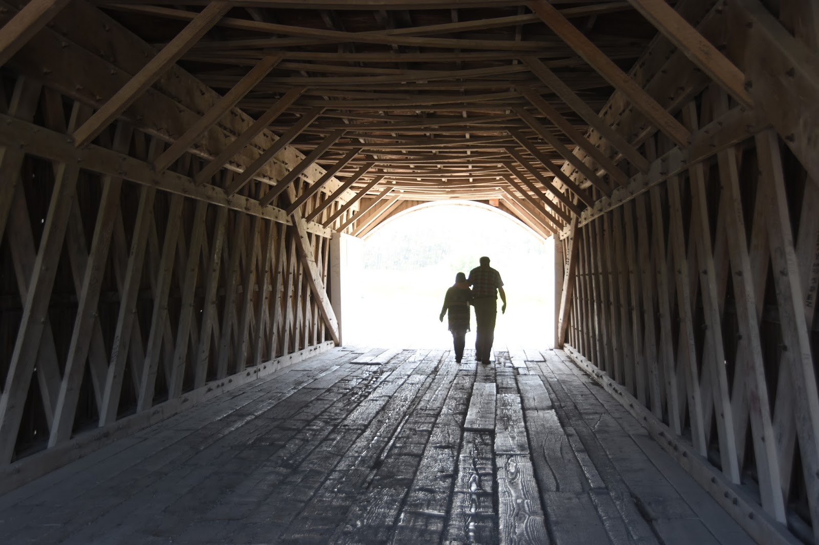
So it was, that as we motored south on Route 169, busily listening to our current book on tape about Lincoln and his Civil War generals, we saw in the distance one of those brown signs that usually indicate something of historic importance is approaching. I slowed down and, when I saw that it was a turn-off sign for the road to a historic covered bridge, I wheeled over and stopped on the shoulder. The sign said, "Hogback Bridge 3.5 miles."
"Well," I told Concetta, "how can we pass up an opportunity to shoot a covered bridge when it's only 3 1/2 miles off the highway?"
Concetta looked skeptically at the barely hard-packed road so recently, and so thoroughly deluged with many inches of rain. "I don't know," she said. "The RV doesn't do well on these bumpy roads."
I wasn't exactly sure how she knew that since we hadn't had the new RV off-road yet. "Come on," I said. "It's only 3 1/2 miles. It'll be a piece of cake."

And so it turned out to be. Yes, there was the occasional rut, chuck-hole, and muddy spot. But all-in-all, we sailed along on that dirt road just as smooth as you please with only a minor amount of shuckin' and jivin' to avoid the aforementioned items. And there was only one minor accident when our wicker basket full of potatoes, tomatoes, and assorted fruit came crashing down on my head from the cab-over bed where we keep such things.
Still, if you want my opinion, the dirt-road ride was well worth it, as our covered bridge destination lay in just the prettiest setting across the North River that you'd ever want. It was a photographer's dream-come-true, as I suppose Clint would be more then happy to affirm. We stayed for about a half an hour, getting mud clogged on our shoes from the muddy bridge approach, but having just the best time trekking from one entrance of the bridge to the other, and shooting the structure from all sides.
Once back on the highway it wasn't any time at all and we were pulling into Winterset, the birthplace of one of American's premier heros, Marion Robert Morrison -- John "Duke" Wayne. By the way, there are lots of covered bridges in Madison County, should you ever consider spending some time in Winterset and tracking them down. Our handout map had no less then six, and I suspect that there might be more just off the edges of the map.
When we got to Winterset we found a side street near the town square -- you knew they'd have one, right? -- and took our usual two or three spaces and then set off to stroll the square and appreciate the many surrounding Victorian buildings before we tracked down the Wayne museum that was just off the square. Just as we'd found in Adel, the commercial buildings in Winterset are just the cutiest, most historically evocative, that you'll see in the mid west. If you were to remove all the modern modes of transportation, you could easily step back 100, even 150 years, and they'd look right at home.

We'd found that the morning light was a bit flat in Adel, but by the time we'd gotten to Winterset the sun had really come out in all it's architecture-warming glory and we had a great time strolling and taking in the many photographic delights. Concetta has begun to shoot things with her IPhone and doing a darn good job of it. Sometimes she gets better shots, with better light then I do.
Once we'd done the complete circuit of the commercial buildings on the square it was time to go find the John Wayne Museum. While walking I just happened to look up at one point and saw the museum just a block south of the square. So off we went with the clock swiftly approaching the 12:00 p.m. hour. The museum is mostly brand new and looks it. I'm not sure I would have gone with architecture that looks quite as modern as they did, but once inside you don't really care. The museum is not extensive, and the entrance price is a tad steep in our estimation, but if you come all the way to the outskirts of Des Moines and don't go, you'll probably regret it later.

There isn't a lot of memorabilia to see, and the gift shop takes up as much space as the museum, but both of us really enjoyed the 10-minute film that vignetted lots of Wayne's films that left us feeling very proud of Wayne's achievements, as well as his undying patriotism. People often make fun of Wayne's acting ability, including us, but his "non actor" style I think is what endeared him to millions.
By the way, if you're a fan of Wayne's movie, "The Quiet Man," with Maureen O'Hara, the museum has the two-wheeled cart from the movie. And, the clerk hastened to tell us, they are shortly going to have Maureen's scarf, worn in the movie, that she willed to the museum when O'Hara died last year.
Everybody always wants to know how screen actors got their stage names. Here's what Wiki has to say about "the Duke:" "While working for Fox Film Corporation in bit roles, Wayne was given on-screen credit as "Duke Morrison" only once, in Words and Music (1929). In 1930, director Raoul Walsh saw him moving studio furniture while working as a prop boy and cast him in his first starring role in The Big Trail (1930). For his screen name, Walsh suggested "Anthony Wayne", after Revolutionary War general "Mad" Anthony Wayne. Fox Studios chief Winfield Sheehan rejected it as sounding "too Italian". Walsh then suggested "John Wayne". Sheehan agreed, and the name was set. Wayne was not even present for the discussion.

And here's another thing we learned at the Wayne's boyhood home when we toured after the musuem: The Morrison family dog was named "Duke." Marion Robert Morrison went everywhere with "Duke," especially to visit the guys at a southern California firehouse. Since someone was always calling the dog, and often the firefighters didn't actually know the boy's name who came with the dog. So, they started calling both the boy AND the dog "Duke." Marion Robert Morrison liked the name so much (and his own first name so little) that he started prevailing on townsfolk to call him Duke as well. Anyway, true or false, that's what we were told today as we toured the tiny, tiny -- perhaps 400 square feet -- Morrison family home in Winterset.
The Morrisons moved away from Winterset, to another part of Iowa, for the elder Morrison to take advantage of a business opportunity. Then, when "Duke" was about seven, the family moved to southern California so that the father's asthmatic condition would improve.
By the end of our visit Concetta and I were so impressed with Wayne's story that I couldn't resist buying a small biography of his life just to learn a few more details. Though Hollywood movie stars don't normally impress me, every once in awhile you have to make an exception and broaden you horizons.
Once we had departed the Wayne Museum it was time for lunch. Acting on a point-of-interest sign that we had seen when we walked to the Wayne family home (around the corner from the main museum), we located the city park and enjoyed a pleasant lunch hour with yet another barn-red covered bridge in our field of view. I might add that the Winterset municipal park has an area where they have set up campsites for RVs. I counted more than a dozen that seemed to have both water and electrical. I suspect that there's probably a dump station for the sewer, though I didn't actually see one. Had it been later in the day we would certainly have taken advantage of the opportunity to stay the evening in such a pretty town.

"Okay," I said to Concetta, as we rolled out of town. "Now we have to put some miles on so we can reach Ottumwa, Iowa, by late afternoon. And that's just what we intended to do. Only problem was that just a couple of dozen miles down the road we went sailing by a sign which read, "Historical Site, Mormon Cemetery."
For about three seconds I kept rolling on, but then I pulled over to the side of the road and turned to Concetta. "I think I'd like to check that cemetery out," I said. We were sitting on the ultra narrow shoulder of an ultra narrow rural highway. There was nowhere in sight to turn around.
"How are you going to get back there?" Concetta asked, in that tone of voice that always implies she'd prefer I didn't kill us in the process or put us in a drainage ditch.
"Well," I said, "I've got to find a place to turn this thing." And so we pulled back into the travel lane and rolled another half mile south until I reached a driveway.

Concetta looked back at the driveway and the tone was back. "Are you sure you can put this big rig into that tiny driveway?" she asked.
Actually I wasn't sure, especially if I wanted to avoid hitting the guy's all too prominent mailbox which stood just off the highway, but close beside the driveway. But nothing ventured, as they say. I pulled a bit forward some more, then started my backing maneuver. When the front end of the truck was mostly blocking the southbound lane I glanced nervously up the road, then back to see if I could see the mailbox. I couldn't see it, but neither could I get out and check its location. Fearing that I was too far to the north I pulled forward and back onto the shoulder, rolling just a bit further south this time. Checking for any oncoming cars in my lane, I began the wide sweeping backing maneuver again. This time I could plainly see that I was missing the mailbox and my passenger side dualies where still on the driveway and not descending into the drainage ditch.

Not wishing to press my luck, once I was back far enough, even though the nose of the truck was still blocking most of the southbound lane, I cranked the wheel to the left and successfully pulled into the northbound lane and headed north. Moments later we had turned into the cemetery road and were headed west.
Now unlike the dirt road we had traveled in the morning, the cemetery road had suffered a good deal more from the recent rains. Concetta was understandably anxious about are ability to proceed through the up-again-down-again undulations of the tiny road. But I figured that if the surrounding farmers had been able to get their equipment down there, we'd do alright as well. "Besides," I told here, "the UPS truck has to get down here and he's just slightly smaller than us."
It wasn't long before we came to a fork in the road. As so often happens when you're boon-docking, no informative road sign was in evidence. Choosing the road MORE traveled -- the left one --, we rolled on. Then, in just another two or three minutes, we came to yet another fork. For no particular reason, since both choices seemed to have been traveled about equally, I once again chose the left fork. Moments later we crested a hill and saw nothing before us to indicate a cemetery as near, Mormon or otherwise.
At that point I was ready to find another "impossible" place to turn a thirty-one foot rig around, and just get back out to the highway and continue on to Ottumwa. But just at that moment a red pickup, that had been sitting about five or six hundred feet ahead of us on the rutted farm road, began to move toward us. As he approached Concetta suggested that I get out and ask for directions. Though a fairly typical male when it comes to asking for directions, I nevertheless opened the door and stepped out.

The truck drew up beside the RV and stopped and a friendly looking chap asked me if we were looking for the cemetery.
I said. "How did you know?"
"Everybody is always looking for the cemetery," the young man said. "Just drive down there about a quarter of a mile and you're there."
All the time we had been talking there was an older man with a bright orange hat sitting on the tailgate of the pickup and he seemed to get ever more animated the longer the young man and I talked. Finally he spoke up. "Just go on down there," he said. "I'll come down in just a minute and tell you about it."
Wow! We thought. We just might get a guided tour. Well, as it turned, we got much more than a guided tour. We got an entire college course on the Mormon migration from Nauvoo, Illinois, to Winter Quarters, Nebraska that lasted for the better part of ninety minutes.

When the orange-hatted man arrived at the cemetery entrance where we had parked, he immediately launched into the history of his property and the Mormon settlement of Mount Pisgah that once existed there. The settlement had been set up on the Mormon Trail between Nauvoo and Winter Quarters to assist stragglers who were having a hard time making the journey.
Our new friend was named Bob Brown, and he told us the migration lasted from 1846 until 1852 and involved literally thousands of immigrants. Bob thinks there may be as many as a couple of thousand bodies buried on his property and just hundreds and hundreds of cabin sites and crude dugouts where people lived. Most likely, not many families lived at Mount Pisgah the whole six years, but stayed awhile and rested, then moved west.
A small amount of archaeology has been done on Bob's property, but for the most part he doesn't allow anyone to disturb either the huge number of graves, nor the cabin sites. The discussion of archaeology brought up what turned out to be Bob's favorite topic: Divining with bent wires to find buried objects.
I remember when I was a kid my dad used bent coat hanger wire to find buried pipes and other metal objects. Watching my dad divine the location of a gas pipe or similar object constitutes one of my earliest memories. But Bob has taken divining to a whole new level. He finds everything from graves and homesites, to wagon ruts and trails with his technique. Holding the bent wires very, very lightly in each hand, separated by perhaps ten or twelve inches and parallel to each other, you carefully walk over a piece of ground. When the extended portion of the bent wires begin to revolve toward each other, you have found your target.

Now comes the part I had never heard before: Bob believes that disturbed earth alters the magnetic orientation of the zillions of earth grains beneath your feet, which through time have become oriented in one direction only commensurate with the earth's magnetic field. So if you have dug a trench for a cabin foundation, and then eventually earth fills in that void, their exists a magnetic anomaly. This anomaly is what the bent wires are reacting to.
Okay, I buy that, even though I couldn't get the wires to behave for me at all today. I know I used to do it as a kid so my technique is probably a little rusty. But whatever the truth of the technique turns out to be, Bob told us that when he had the Mormon Church come do archaeology work on his farm, they brought with them a truckload of things like ground penetrating radar and other sophisticated pieces of gear. Before long, Bob said, they had switched to using his bent wire technique and were quite successful in finding their sought-after objectives.

Both Concetta and I agree that our chance encounter this afternoon -- that I admit I almost gave up when I didn't accomplish the backing procedure the first time -- easily turned out to be the most interesting and rewarding adventure we have had yet. It was just glorious standing on the top of Mount Pisgah, looking out across the immigrant trail as it wandered west into the distance, and visualizing the lives of the hardy Mormon settlers. We realized that perhaps as many as 2,000 people were buried in nameless graves on the verdant hillsides that stretch out on all sides of us. Perhaps none of these people will ever be known or identified. My own 2-times great uncle, Stephen Daley, may in fact be one of them.
Bob showed us a site near his barn where he has dedicated a small hillock to laying out where cabins had once stood. He's buried railroad ties in 12 x 14 foot rectangles to indicate the size of the cabins. There he plans to allow anyone who knows that their ancestor died anywhere in the Mount Pisgah area to put up a memorial stone to commemorate their passing. One stone already rests peacefully at the foot of Bob's cabin area.
In closing I just want to say that Bob impressed us so much for his love of history, his realizaton of the sacredness of Mount Pisgah as a Mormon monument, and for his willingness to continue the study of a little understood chapter of American history. Bob continues the education process by volunteering to bring school children to his farm and explain the historic events that took place there. He has also been instrumental in forming a Mormon Trail historical group to pull others into the process. We say, Bravo, Bob. Good job indeed!
It was tough to pull ourselves away, that's for sure, but as the sun began to sink in the west, we had to move on. Thankfully, we found a camp in Oceola, which we were able to find early on and saved ourselves the long drive to Ottumwa. Tomorrow? Well, who knows. If you see that little-used road off the main track, we advise you to take it. You just never know what excitement lies ahead. So, until we meet again, we wish you Happy Travels.

3 comments:
Great story
I guess my grandfather was correct when he said "chance meetings don't happen by accident they happen so you get your questions answered"
Don
John Wayne graduated from Glendale High School, right in your back yard when you were growing up Tom.
More then that even. My Dad graduated from Glendale High in 1938, just a tad behind the Duke.
Post a Comment