Saturday, May 17, 2014

Day 74 - Gunnison to Grand Junction, Colorado

Our first trip in this 1996 vintage RV took place in the Fall of 2011. If memory serves, we traveled over 7,000 miles, took in many of the most northern states as far east as the Great Lakes, and turned around to come home when we reached Ohio. On October 1st of 2011 we rolled into Gunnison, Colorado, and almost immediately spied one of the most intriguing museums that we had yet seen on that trip. It had a Denver and Rio Grande Western narrow gauge train in the front yard, a bunch of western buildings of all descriptions, and a very large museum building that we hoped would capture our interest for a good part of the morning.

We got to Gunnison around noon, so we parked across the street from the museum property, on the edge of a very nice public park, and had a leisurely lunch. After lunch, we dashed across the busy main street of Gunnison, and up to the front door of the museum. There we encountered a large sign which said, "Closed for the Season." "Open May 20th to September 30th." We had missed catching the museum when it was open by a single day. Just a SINGLE DAY!

Last night when we rolled once more into the town of Gunnison, the museum was the very first thing to grab our attention. It was then that we remembered that we had missed it on the previous trip through Colorado. Unfortunately, we did not remember just exactly when the museum opened for the summer.

As I type this account, it is May 17th, 2014. In exactly three days the museum will open again for the summer. THREE DAYS! Now obviously we can't wait around for the next three days for the darn place to open. We just had to move on. But it sure breaks our hearts to have to miss the museum yet again. Guess we're going to have to plan a trip around the museum's schedule so we don't miss it a third time.

Sad but wiser, we turned around and once again headed west on Interstate 50 toward central Utah and home. Fortunately, we did have a couple of other options in towns down the road, so we wouldn't be driving all day, but would be taking the occasional break.

The next major town after Gunnison was Montrose, Colorado, which promised to have not only a sort of frontier museum, but a Ute Indian museum as well. Most of the morning we just motored through the magnificent Rocky Mountains enjoying the snow capped peaks, the wild flower-strewn meadows, and the cold rushing streams beside the highway. Naturally, we had John Denver to keep us company as he belted out his Rocky Mountain songs on the disk player. It was almost heaven!

Dropping out of the Rockies into the lower elevations we came upon Montrose about mid morning. Before long, we had ferreted out the Pioneer Museum and had stowed the rig for a little R&R among the stuff that I love best, things with lots and lots of rust on them. Concetta is not so thrilled with rusty things, but we managed to keep busy trying to identify all the remnants of the past, both inside and outside the museum building. There was farm machinery, printing machinery, ancient laundry day accoutrements, and a whole host of things that on my best day I couldn't identify.

Though not even the museum docent could identify one piece of equipment they had tucked in next to the cowboy cabin, I knew as soon as I walked over to it that I had finally found an antique for which I have been searching for years and years: it was a mule-drawn, ice-cutting plow. What in the heck is that, you say? Well, in the old days when refrigeration was only a pipe dream, nearly everyone in the country needed ice to keep things cool in their "ice boxes." Even today we sometimes call the modern refer an ice box. Most folks don't really know where the ice came from that was delivered to their grandparents' door.

Well, I'll tell you. Most often it came from frozen lakes where ice was cut and stored during the winter for delivery to customers during the summer months. But this ice was far from easy to obtain. If the ice on the local lake was a foot thick during the winter, how in the world did that ice get cut into manageable chunks and eventually get delivered to the hundreds of town ice boxes?

This is where the mule-drawn, ice cutting plow comes into the picture. The plow has a series of sharp blades, mounted all in a row, that can cut down through the ice, going a little deeper with each pass of the mule as he draws it across the frozen lake surface. Mounted about two feet away from, and alongside of, the cutting blades was a similar set of non-cutting blades that could be dropped into the slot just cut in order for the next cut to be equidistant from the first cut. As the mule walked back and forth across the lake, he would finish with a large series of parallel cuts. The cuts did not go all the way through the ice. About a quarter of the ice thickness would remain to support the weight of the mule, plow and other workers.

Once the first set of cuts were finished, then the mule would draw the plow back and forth making cuts at right angles to the first set of cuts. When this was finished, the whole lake had been neatly cut into rectangular or square blocks of ice ready for the men with special hand ice saws to finish cutting each individual block loose from the rest, and floating the blocks over to where the ice house had a conveyer set up. At the conveyer intake, the ice blocks would be moved from lake level, up the conveyer, and finally into the ice house at whatever elevation was required. The conveyer could change it's end-point altitude as the ice house was completely filled at any given level. As each block hit the ice house floor it had to be kept moving until it reached it's individual storage spot. If the ice were to stop moving, even momentarily, it would freeze to the blocks underneath. As you might guess, ice harvesting was not for the faint of heart as the blocks weighed hundreds of pounds each.

Later on the large blocks of ice would be further cut down into manageable pieces for your local ice delivery man to handle. He'd load them in his wagon using a set of ice tongs, carry them to your door using a special leather shoulder pad, and you'd be set for the next few days. In many towns, you would put a special card in your window which told the ice man how much of the frozen stuff you wanted. The card had four triangles printed on the front, each with a different weight of ice desired. Whichever weight was uppermost in your window would signify the amount you wanted delivered.

And there you have it. Up to now, I had never seen an ice plow except in vintage photographs. It was well worth the few bucks entrance fee we paid to visit the museum. Most of the rest of the museum's exhibits and displays were bit dusty and tired, as is the case for many museum facilities nowadays that suffer from lack of funding, lack of interest, or both.

Now that I had MY gem of the day, it was time to go find Concetta's. Concetta had set her sights on the Ute Indian museum on Route 550 on the south side of Montrose. There we hoped to learn a little bit more about the local Native American culture, and hopefully see some of their handiwork. In both these endeavors we were not disappointed. Unlike the Pioneer Museum, the Ute Indian Museum was fresh and modern and extremely well cared for. As we pulled up and parked, We were immediately excited to see that museum was not only an indoor experience, but an outdoor one as well. Flanking the museum building, the tribe had set up a series of teepees that appeared to be period correct in every way.

Naturally, the combination of the white teepees, and the even whiter fluffy clouds against an achingly blue sky made photographing the scene a no-brainer. Even before we set foot in the museum facility itself, we made a bee-line over to the teepees so I could capture the wonderful scene for the blog.

Now, when it comes to the history of the westward expansion, I must admit I've always found the stories of the covered wagons and the settlers far more interesting than the native culture, probably because I actually have an ancestor who was a wagon master on a couple of Mormon trips. But thanks to Concetta, I am gaining a much greater appreciation of the Native American culture.

We spent the first twenty minutes or so in the museum watching a film on the Ute Indian Bear Dance ritual which we both found very interesting. After the film we found our way to the tribal crafts area of the facility. My goodness, some of the leather work and bead work and other art was just way beyond outstanding. I just couldn't get enough of it, and took as many photos as I could.

All too soon our visit to the town of Montrose, Colorado was finished and we had to move on down the road. Just over 65 miles to the west lay the town of Grand Junction, where we are presently encamped at the local KOA. As it turned out, it was well that we motored west when we did. When we arrived in Grand Junction, where unbeknownst to us, several different entertainment venues were in progress, we snagged the very last full-hookup spot in the camp that hadn't already been reserved. Good thing. I would have hated to have my cocktail hour delayed while I searched, probably outside of town, for another suitable campsite.

And that's our day. No plans for tomorrow as yet, but I'm sure there must be something out there in western Colorado or eastern Utah to capture our fancy. Stay tuned. And, if you happen to have one of those mule-drawn, ice-cutting plows languishing in your garage, do give me a call and I'll be happy to take it off your hands.

Ciao for now, and Keep on Traveling!

Friday, May 16, 2014

Day 73 - Pueblo to Gunnison, Colorado

When I checked in at the KOA (Kampgrounds of America) office just now the attendant asked me how I was doing. As I usually respond to such questions, I said, "Absolutely wonderful!" Then I went on to say, "but I could use a lot more sun and a lot less wind." And that was the truth. Though the morning hours were basically sunny as we headed into the Rocky Mountains from Pueblo, Colorado, as the day progressed the sky grew progressively more gray and overcast, which always hampers my photography. As for the wind, well, it just blew all day long. But the KOA clerk must have taken pity on me because, as I type this account, the wind has died off and the sun has come out. It's suddenly so warm in the coach that we had to open the windows. But hey, it's that ol' "box of chocolates" thing. When you're an RVer, you never know what you're gonna get.

Yesterday, when we arrived at the KOA in Pueblo (photo top left), they gave us a front row seat on the interstate as well as the Burlington Northern/Santa Fe Railroad line. Consequently, we had no lack of ambient noise to drown out all the annoying desert environment quiet that can just drive you bats. Of course, I'm a train-lover from way back and the long-haul freights going by every fifteen minutes didn't bother me at all. Still, before long, my brain had decided to replay some of the Mary Chapin Carpenter tunes we had been listening to that day, so I can't even tell you how many freight cars full of coal went by before we went to bed.

Our route today involved just staying on Interstate 50 all the way over the Rockies. We did, at one point, wander a bit off track but were alerted to the fact when the road sign said we'd be in Fairplay by nightfall. Well the map told us that Fairplay was north and we were headed west, so a few miles of backtracking was in order. We got deviated in Salida, Colorado, when the highway sign said, "turn here for the historic section of Salida." Little did we know that when you took them up on that offer, you ended up on Route 285 to Fairplay once you came to the far end of the historic district. No mention of the road not returning you to your original route was ever made. I imagine that Fairplay has not been getting its share of the tourism dollar, so the town fathers came and stole the signs that directed you back to Interstate 50.

Speaking of weird fellow humans, I ran across a really strange lady today. We had decided to take the turnoff to the Royal Gorge and had driven as close to the gorge as possible, parked, and then hiked around the rim getting photographs to show y'all. At that time of the morning, the sunlight was magnificent, and our view of the river and the railroad tracks at the bottom of the gorge was unsurpassed. It was a little tight getting the rig up along those tiny dirt roads and around the tight bends meant mostly for passenger cars. In case you've ever been to the Royal Gorge you know that in years past you could drive over the bridge up there and REALLY get a good view, but last June somebody set fire to the forest up there and burned over 100 structures in the park. Now the paved road is closed while the National Park Service reconstructs everything and tourists must use a dirt road that takes you to an temporary overlook. Not quite as awesome, but the best they can do at the moment.

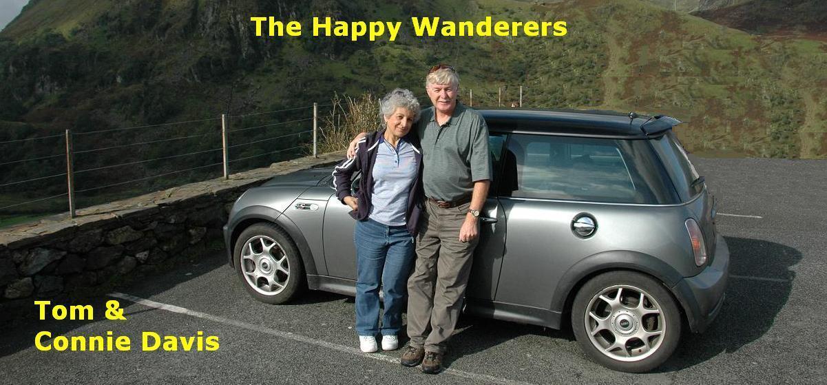
But I was going to tell you about the weird lady I met. We were coming back down off the mountain, after visiting the Royal Gorge overlook, and I happened to notice just the cutest little camp spot beside the road that I had missed on the drive in. The motif of the camp was vintage travel trailers. But not just trailers. You could rent a 1950s-era trailer which came with a 1950s-era car. The first one I saw, and was ultimately able to photograph, was a blue and white 1958 Chevy four-door attached to a tiny trailer of the same age.

Believe me, I couldn't get the rig stopped fast enough. Then, camera in hand, I marched up the drive to do some serious photo shooting. Since the '58 Chevy was nearest the road I grabbed a framed shot of that car and trailer. Then I continued up the drive. Next I encountered a Nash Rambler and it's accompanying trailer. Standing beside the car and trailer were three people, two men and a woman. Catching site of me, the woman said, "May I help you?"

Realizing that the woman was probably a manager of some sort, I said, "Is it okay if I shoot photos of your camp?"

At first she didn't answer me, but walked over to where I was standing. "If you'd like to rent," she said, when she was standing next to me.

Figuring that she just misunderstood, I said, "Oh, no, I just thought the camp idea was cool and wanted to photograph it."

"No," she said. She had a big grin on her face and I still wasn't absolutely sure I was getting the gist of what she was trying to tell me.

So I said, "You're saying no?"

"That's right," she said. "Unless you'd like to pay to stay here."

"How much to stay," I said.

She quoted a price that sounded like Seventy-eight per night, One hundred fourteen for two nights." She was looking right into my eyes when she said that, and she'd never lost her grin. I thought perhaps I had encountered a certified nut case, but I decided to continue to try and persuade her to let me shoot. What did I have to loose?

Taking a new tack, I said, "You know, I'm doing a travel blog and the photographs will be seen by lots of people. Wouldn't you like free advertising?"

"Nope," she said, evidently a little too quickly, as she hastened to add, "Unless you're from Channel 2 or something."

"No, I'm not from Channel 2," I said, "but you still don't want free advertising?" I'm sure sounding as incredulous as I felt.

"No thanks," she said, "I have to respect my guests privacy." The grin was still in place, or perhaps had gotten even broader. I looked around the nearly deserted camp, noting the dilapidated picnic tables, the tired and faded miniature golf course, and the dusty, untended foliage. Not another soul appeared to be anywhere. No workers. No customers. Nobody! The whole place needed about a million gallons of paint just to cover the weathered wood of the various tired buildings. Most of the cars and trailers desperately needed attention as well, or at least have the weeds removed from around them.

"Okay," I said, "No free advertising."

She grinned.

I said, "Thanks for your time." I turned and walked back down the rutted drive, wondering as I walked, just how one could afford to have a negative review of your business hit the air waves that stretch to every corner of the earth. But there it is, I have posted the sign so you can avoid the place, should you choose, well, unless your gig is smiling contests. Then maybe you might want to look this lady up.

It was at this time that we began to see the promise of the Rocky Mountains (photo above left). Snow-capped peaks could be seen way in the distance, beckoning us to come visit. We had a lot of climbing to do on Interstate 50, but we knew having traveled this route in the past, we were in for some mighty fine scenery.

Noon found us wending our way beside the Arkansas River, which begins life in Colorado and meanders its way through three other states. According to Wikipedia, "The Arkansas River is a major tributary of the Mississippi River. The Arkansas generally flows to the east and southeast as it traverses the US states of Colorado, Kansas, Oklahoma, and Arkansas. The river's initial basin starts in the Western United States in Colorado, specifically the Arkansas River Valley, where the headwaters derive from the snowpack in the Collegiate Peaks. Then it flows east into the Midwest via Kansas, and finally into the South through Oklahoma and Arkansas. At 1,469 miles (2,364 km), it is the sixth-longest river in the United States."

Now what do you think about that? I had never paid the slightest attention to the Arkansas, but I can tell you now that it's a very pretty river to spend your day with. You certainly have to keep your eye on the road, because the two-lane twists and turns just like the river. But sometimes it's hard to ignore the beauty beside you has you roll along.

One aspect of the Arkansas River that we encountered right away is the plethora of white-water rafters paddling down its length. In fact, I was so enthralled with the rafters, that I chose a lunch spot beside the river with ample space to set up and photograph the participants as they floated past. Perhaps "floated" is a misnomer, in that a lot of the time the folks in the rafts are paddling for dear life as the rapids fling them this way and that, mostly toward rocks.

As Concetta and I ate our lunch betwixt highway and waterway, I kept a steely eye out for the rafter's appearance. Unfortunately, we had consumed our lunch and had started on our last cup of coffee and no rafters had appeared. I was beginning to worried that I was not destined to get any photos this trip.

Suddenly, I peered out the window, and just in the distance I could make out a trio of rafts approaching. Grabbing the camera, I raced out the door, down the rocky bank, and got as close as I dared to the rushing water. My timing turned out to be perfect, and seconds later the three rafts skillfully navigated the rapids in front of me and floated away on the current. I had gotten a dozen shots, though nothing special I decided since no one had actually been "fighting for their lives" as they approached the huge rock on which I had situated myself. Still, it was better than nothing. I scrambled back up the bank to the RV and settled in to drink the rest of my coffee.

At least that's what I intended. But seconds later, a glance out the window confirmed that yet another trio of rafts was approaching. Once again I grabbed the camera and raced for my spot. This time I crawled further out on the edge of the boulder so the rafters would have to pass right beneath me. And this time I thought that the photos had to be better, closer, more real.

So the lunch stop turned out to be the highlight of the day. After reviewing the photos I saw that they're not National Geographic quality, but I sure had fun. And the memory of sitting on that huge rock as the rafters paddled by will long be with me. And, just to further solidify that memory, I had Concetta shoot me shooting the rafters with the other camera. Who knows, my senior citizen memory may need the extra clues.

When we finally finished the 35-mile-per-hour climb to the top of Monarch Pass, elevation 11312 feet, we decided to do something special. Since I had already entered through the outbound drive at the summit rest stop, I decided to back the rig around into a nearby snow field, and set up a photograph for this year's Christmas cards with the snow-capped Rockies in the background. The shot came off well, and we hope it will work for the card next December.

Leaving Monarch Pass, all we had to do was drift downhill for the rest of the day to reach our afternoon goal of Gunnison, Colorado, elevation around 7,700 feet or so. The KOA here in Gunnison is very nice, very quiet, and we would probably come here again if fate brings us this direction. I'd very much like to come back to Colorado soon and do a more thorough job of exploration. My maternal grandfather grew up in Colorado and lived in several mining towns that I'm sure would be great to visit.

Thursday, May 15, 2014

Day 72 - Lamar to Pueblo, Colorado

It was sure nice this morning in Lamar, Colorado. Just a bit cold when I went out to pack up the water hoses, but not so much that I needed a jacket. Our camp in Lamar, plans for which we made at the last minute, turned out to be reasonably quiet even though it was on a busy highway. I wouldn't say the camp was palatial, it wasn't. In fact, it needed a lot of maintenance as far as we could see. But it had all the necessary utilities, all of which were in good shape, and that's good enough for me. For some reason they do allow stray pets to wander the camp unleashed, which will probably bite them on the ass someday, figuratively or literally speaking.

Our plans for the day called for backtracking just a bit to the north -- about fifty miles -- to visit the Sand Creek Massacre site in eastern Colorado. This is a place that I have been wanting to visit ever since I was a twenty-something and my mother told me I was related to an Indian fighter from the old west. Naturally, that news perked me right up. I learned of this because Mom had accidentally discovered a relative right in Carson City who was the granddaughter of her grandmother's brother, or what you might call a second cousin I suppose.

When Mom met with this relative she learned about Benajah P. Stubbs, her grandmother's brother, who joined the Colorado 100 days Cavalry back in the wild and wooly days of 1864. While most of humanity was off in the East fighting brother against brother in the Civil War, Benajah Stubbs fancied himself an Indian fighter and volunteered to put his life on the line to protect the settlers in the Colorado Territory.

That would have been very laudable if his troop hadn't gotten severely carried away and participated in an attack on a village of largely non-combantant, friendly Indians who had taken up residence in the river bottom land along Sand Creek, a place specifically sanctioned by the U.S. Government. One of the Chiefs in residence along Sand Creek was even flying an American flag above his Teepee to signify the groups friendly status.

Here's what Wikipedia says about what happened: "After several minor incidents in what would later come to be designated as the Colorado War, in November 1864 a force of 800 troops of the Colorado home guard, after heavy drinking, attacked an encampment of Cheyenne and Arapaho at Sand Creek, murdering between 150 and 200 Indians, mostly elderly men, women and children. This Sand Creek Massacre or 'Massacre of Cheyenne Indians' led to official hearings by the United States Congress Joint Committee on the Conduct of the War in March and April 1865. After the hearings, the Congress Joint Committee in their report on May 4, 1865, described the actions of Colonel John Chivington and his Volunteers as ‘foul, dastardly, brutal, and cowardly’."

Now the the 100-days men were not the only military present. Present also was a company of regular army soldiers who were supposed to carry on the fight. The volunteers had been ordered to round up the Indian ponies and not take part in the shooting. However, as it was explained to us today by the park ranger, the volunteers were worried that they might not be seen as having done their full duty. So they threw themselves into the fray, and once involved completely lost their heads and began shooting anything that moved, even unarmed women and children. As few as 125 and perhaps twice that many are thought to have been murdered.

As you might guess, that terrible morning in 1864 has been quite a black mark on the military history of Colorado. In modern times, actually only since 2006 or so, the National Park Service has worked with the involved Indian tribes to do archaeology work at the site of the massacre, establish where the various tribal clans were camped at the time of the incident, and properly bury any remains found. It's been quite sensitively accomplished and we were quite impressed with the job they've done.

At the time my mother made contact with this cousin I became the recipient of a brass powder horn and a sort of large spoon for melting lead to make bullets. Both belonged to her grandfather, Benjah Stubbs. The cousin didn't have any heirs, and she thought that I was the perfect person to have these artifacts. At the time, I did not know about the terrible history that these artifacts might possess.

No, at the time, all I cared about was that I was related to an real live Indian fighter. Only much later did I learn of the significance of what I had inherited.

But the story goes even deeper now that Mom has passed away. One of the things that Mom got from this cousin, now in my possession, was a diary kept by my Great Grandmother, sister to the Indian fighter, during this period of her brother's "heroics" at Sand Creek. When I mentioned this fact to the ranger, himself an avid historian, he became quite excited and asked if there was any way I could make copies of the pertinent pages available to him and the Park Service for inclusion in their study of the massacre. I remember my mother reading the diary to me forty years ago and still can hear my Great Grandmother's account of how her brother and his fellows returned from the raid with scalps hanging from their saddles.

So that I might confront my family's past, I very much wanted to drive the extra fifty miles, weather the sixteen miles of horrible, washboard road, and make that walk out to the bluffs overlooking the massacre site, even though the skies grew progressively more stormy and unfriendly as we drove north. I had really hoped for some decent sunlight to record the terrain, to give me some context in which to visualize the battle, but it was not to be. Throughout our visit and our hike out to the rim of Sand Creek, the whole place took on a sort of sombre, forbidding aurora. Later, as we drove back towards civilization, Concetta and I discussed the possibility that perhaps the Cheyenne and Arapahoe were setting the stage for us so that we might experience that November morning of 150 years ago, not as we wanted, but as they had lived it.

The rest of the afternoon we cruised west on Colorado Route 96, not seeing much to photograph, but just chatting and watching the incredible vistas of eastern Colorado slide by the windows. Concetta wanted me to be sure and tell you about the antelope who pranced across the two-lane ahead of us and then bounded away into the grasslands. I spent much of my time scanning the vintage telephone line that ran alongside the highway nearly the entire day. The line was abandoned, but still had at least a dozen glass insulators festooning the cross-arms of each pole. Overall, I imagine we rolled by hundreds and hundreds of them by the end of the day. At one point, while we were headed for Sand Creek, I actually stopped to see if I could find one on the ground, but had no luck. I could have dragged out the six-foot ladder and climbed a pole, but I didn't think Concetta would encourage me to do that. So, the whole collection is still there for the taking.

I also stopped briefly to take a photo of a BNSF train that was sitting on a siding waiting for opposing traffic. The light was nice and the engine looked new. What the heck?

But for the most part we just cruised on into Pueblo, getting there at a really nice, early hour so we could get into camp and have time for nice cocktail before dinner. Those thoughts evaporated when I stopped for gas at the first big station we encountered in Pueblo and I glanced down at the rear tires to see if they looked properly inflated as I try to do as often as possible. This time the left rear didn't look like it had any air at all in it. I went over and kicked it and it wobbled. That's a really bad sign for a heavy duty RV tire like we're running. It didn't take a genius to see that we'd lost air in that tire, which meant the whole weight of the coach was resting on one tire on that side, which is a place you don't want to go while traveling at highway speeds.

So the first order of business was to find a tire store and QUICKLY! I left the gas station driving as sedately as possible and tried to use the magnificent Davis luck to scare up the necessary tire store, like right around the corner. When that didn't work I found a nice level spot in a bank parking lot and we called the roadside assistance folks. Though the chap at Allstate Roadside didn't sound all that on the ball, he did in fact have a couple of brawny tow truck drivers knocking on our door within fifteen minutes.

The tow truck guys changed the spare out for the flat tire and installed it on the rig. Once that was accomplished we once more went in search of a tire store using directions from the tow truck guys to guide us. Though we initially missed our turnoff and ended up in a Wally World tire shop, the guy there further directed us to a shop called "Colorado Tire" and we were soon throwing ourselves on the mercy of a half dozen tire guys just down the road.

Now these guys at Colorado Tire were simply wonderful. It was almost like the old-time service stations where you drove in and six different guys came running out to service your '50 Chevy. These guys at Colorado split up the duties like they had just been waiting for us to appear. Even though they were about to close for the day, one guy took on the flat tire to see what was required, one jacked up the rig and removed the spare, and one guy re-installed the spare underneath the rig. Then, once the original tire had been fixed (it was only a faulty valve stem), the guy who had removed the spare than installed the original tire where it belonged. Meanwhile the guy who had stowed the spare back where it belonged went around and checked the air in all the tires. Amazing!

I was so impressed with the guys I gave them a ten-spot and told them to buy a case of beer on me and kick back after work. The whole process came to under sixteen dollars. Fantastic bargain! So, bottom line, if you're ever anywhere near Pueblo, Colorado, and need help with your tires, call these guys at Colorado Tire. They will do a great job for you and not charge you a fortune. And tell Shawn and Mario I sent you.

As you can see, dreams of a quiet cocktail out on the lanai wafted away in the afternoon Colorado breeze. Still, things could have been a lot worse. Had the weight of the coach been too much for the one port-side tire to support, it might have blown as well. If we would have been eight miles into the desert on that washboard road, well, getting a tire technician or the Allstate rescue squad out there might have been a real adventure.

Or, had the tire given out on the freeway we might have put the rig in the ditch. We certainly wouldn't be having cocktails for awhile if that had happened.

So, all's well that ends well, as the famous saying goes. And you have to wonder, were the spirits of the Cheyenne and Arapahoe watching over us today for having cared enough to pay them a visit? I think they were.

Wednesday, May 14, 2014

Day 71 - Ellis Kansas, to Lamar, Colorado

Today didn't go as planned, and that's an understatement. From the moment we pulled out of camp it became a toss-up as to what exactly was going to happen in the next few minutes or hours. You may remember that we stayed in the municipal camp in the town of Ellis, Kansas, last night, and there was no camp host on site. No problem there. Posted right in front of the camp was a sign that informed campers that a member of the local police "might" be around to collect the fees. If they did not, in fact, show up, the sign requested that the camper search for the police station on Jefferson street and deliver your check in person.

You may also remember that before leaving Ellis this morning I wanted to see the boyhood home of Walter Chrysler, the man for whom the Chrysler Corporation is named. Walter may have spent his boyhood in tiny Ellis, Kansas, but he certainly made his mark on the world. According to Wikipedia: "Chrysler apprenticed in the railroad shops at Ellis as a machinist and railroad mechanic. He then spent a period of years roaming the west, working for various railroads as a roundhouse mechanic with a reputation of being good at valve-setting jobs. Some of his moves were due to restlessness and a too-quick temper, but his roaming was also a way to become more well-rounded in his railroad knowledge. He worked his way up through positions such as foreman, superintendent, division master mechanic, and general master mechanic."

Chrysler's automotive career began in 1911 and he worked his way up in several automotive organizations such as Buick, General Motors, and Willys. When Chrysler left Willys in 1921 after an unsuccessful attempt to wrest control from John Willys, he acquired a controlling interest in the ailing Maxwell Motor Company. Chrysler phased out Maxwell and absorbed it into his new firm, the Chrysler Corporation, in Detroit, Michigan, in 1925. Chrysler went on to acquire Dodge, as well as to create the Plymouth and DeSoto marques. Walter became a very, very successful auto magnate.

Unfortunately, we were less successful in our attempt to see Chrysler's home. As we read on the sign at the front gate, winter hours called for it to open at 11:00 a.m. Since it was only 9:00 a.m. at the time, we decided to move on.

Where we moved was in concentric circles through town as we tried to stumble on the police station. If you read the blog yesterday, you would have thought we would have no trouble finding the police. They certainly didn't have any trouble finding US yesterday! But alas, it took us a full twenty minutes to find Jefferson street. And then, when Concetta appeared with the check book, she couldn't help but notice that the clerk seemed surprised to the point of amusement that we had actually been honest enough to come find them. But hey, that's who we are.

Once out on the highway, we set off at a brisk pace hoping to make up some time. But then I got to thinking about our left front tire. Over the last couple of weeks I've begun to notice that the left front, and to a much smaller extent, the right front tires seem to be wearing unevenly. I didn't think that it posed a hazard, but I really wanted to ask an expert.

So, we started exiting the Interstate as we came to various small towns and driving through hoping to see a tire store that was both open and not too crowded with customers. When we got to the improbably-named town of Wakeeney, we found just such a place. I turned into their drive and stopped in front of the modern-looking shop. Jumping down from the rig, I wandered into the open bay and looked around for the owner or similar decision-maker.

Before long a very amiable chap by the name of Troy came over to me and asked if he could help me. I asked him if he'd come look at my tires if he wasn't in the middle of something, which he instantly agreed to do. Out at the rig, I ran my fingers over the uneven wear and asked him if he thought it might blow on me before I got back to Nevada. Troy studied the tire, then called another man over, who also studied the tire.

"Looks like the camber is off," Troy's co-worker said. He held his hands in front of him, tipped slightly together at the top to indicate that the front tires were leaning in at the top and out at the bottom. "Left wheel more than right," he added.

"It's a problem with these Fords," Troy said. "It's not just your's. They all do it. Probably need a couple of shims to bring it back straight. But you can probably get it home this way."

"What do you think about reversing the tire on the wheel so the worn part is on the outside?" I asked.

Both men studied the tires. "Well, yes, that would give you more rubber where it's wearing the most," Troy said.

"When would you be able to work on it? I asked.

"We could squeeze you in right now," Troy said. "Just pull it up on the apron."

And that was that. In an hour's time Troy had dismounted both tires, reversed them on the wheels, and remounted them. He even used a torque wrench on the lug bolts as a true professional will do, but most garage mechanics seldom bother with. Additionally, when Troy got the right front wheel off, he discovered that the grease cup had fallen off the hub and grease was leaking into the wheel area. Left unattended we'd have eventually run out of grease resulting in rather grave problems.

The hour I spent with Troy this morning was one of the most rewarding conversations I've had with anyone on this vacation. We talked about all things mechanical and about what our Dad's had taught us. At one point he mentioned that he'd been looking for a mechanical tire changer like you normally saw in most gas stations in the 1950s. My dad actually used to install them to make extra income in those days. I told Troy that I had one and would be happy to give it to him. All he had to do was come out to Nevada to collect it. He smiled and said, "well, you just might see me sooner than you think."

Great guy, that Troy. And if you're ever traveling route 70 through Kansas and need help with your tires and wheels, or, I suspect, with whatever automotive problems you happen to be having, be sure and stop in and see him at Wakeeney Tire and Service. You'll be glad you did.

Leaving Wakeeney with a new sense of elation now that I knew my tires were more trustworthy, we transitioned from Interstate 70 to Interstate 40. My intent was to drop a little south as we entered the state of Colorado so that we might visit several points of interest I had seen on the map. The first was the Flick fossil museum in Oakley, Kansas. The second was the Butterfield Trail Museum in Russell Springs, Kansas. And finally, I wanted to finish up the day by camping somewhere near the Sand Creek massacre site in Colorado so we could visit it tomorrow before we head west.

Well, the fossil museum was a bust since it was closed for refurbishment or something. We did end up eating lunch in their parking lot since we'd already spent the time finding the place and it was nearly noon. The trip to Russell Springs after lunch was a little more adventuresome. First of all, the wind in western Kansas today was nothing to take lightly. In buffeted us from all four sides, it seemed and, combined with the gusts of passing eighteen-wheelers, made it difficult to keep the rig on the road. In addition, great black storm clouds circulated on all four sides of us, interspersed with blue sky and fluffy white clouds. It was like Kansas just couldn't decide what sort of weather it wanted today and just wanted to prepare itself to clobber us if it felt like it.

Now Russell Springs was twelve miles south of Interstate 40, which made Concetta roll her eyes a bit, but I convinced her that the history of the Butterfield Stage Lines would be very interesting indeed. But once we arrived in Russell Springs, we began to feel a bit uneasy, since the "springs" looked largely deserted except for an imposing three story court house which, it turned out, housed the museum, and darn little else in any direction. Still, the sun was shinning around that time, the welcoming "Open" sign was in the window, and that size of building did promise enough room to display whatever stagecoach days materials that your heart desired.

Well, that's not entirely how it turned out. Once inside, Concetta and I saw immediately that the Russell Springs Butterfield Trail Museum was more of a depository for anything and everything the neighbors for fifty miles around had no longer wanted to continue storing in their barns and attics. It was also plain to see that no professional curator had ever set foot in the place. Still, to be fair, I'm always game to see what interesting artifacts and memorabilia I can turn up that I've never seen before. With a shrug, we began our search for just such entertainment.

Now we must hasten to tell you that the resident docent who chatted with us, brought us up to date on local history, and explained some of the displays, was the most charming woman you could ever want as your host. We enjoyed interacting with her very much. But most of the displays were rather sad and faded and dusty, and the whole place was in desperate need of reorganization.

One of the items that I came across that stopped me in my tracks was the property listings and tax rolls showing who had owned what farm or piece of property going back to the 1800s. I was simply floored. No care was being taken to preserve these priceless documents and they simply were stacked on shelves getting progressively more and more dusty. I suggested to the docent, whose name I should have learned but didn't, that she should contact the folks at Ancestry.com and ask them to come out and digitize those records before something happened to them. I hope she does that because they are an extremely valuable resource for genealogists.

Wandering upstairs, Concetta and I found the remnants of the local library, evidently, which contained books going back to the 1800s, National Geographic magazines going back a hundred years, and stacks and stacks of just about any library-oriented material you could imagine. One book I pulled off the shelf was Benjamin Franklin's autobiography from sometime in the 1890s. Wow! All the stuff was so old it just amazed us.

We spent about an hour at the museum, though we didn't really encounter much in the way of Butterfield material. Russell Springs had been a stage stop for Butterfield on its line that ran from Fort Riley, Kansas, to Denver, Colorado. You will probably remember that we stopped yesterday at Fort Riley, which is a nice tie-in with today's visit to Russell Springs. And they did have a stagecoach out in the barn behind the museum, but I would have liked to have seen more material devoted to the stage line.

Once we left Russell Springs the storm grew worse and rain began to fall in concert with the buffeting of the winds as we headed west toward Colorado. Our goal was to spend the night in Cheyenne Wells, Colorado, which purportedly had camping of sorts. But once at the camp ground, we discovered that only 50amp service was available. We are carrying no 50amp to 30amp converter, so we had to move on.

Since my intent for tomorrow is to visit the Sand Creek Massacre site, we decided to drop south out of Cheyenne Wells, and find a camp closer to the battlefield. This we did in the town of Lamar (photo left). Although it was perhaps a seventy-mile drive to get to Lamar, the camp is very nice, has full hookups, and the price was extremely reasonable (for Good Sam members) at $18.00.

So that's it. Some things clicked. Some things didn't. But that's life on the road. Tomorrow we'll be back for more, and hopefully get to spend some time communing with the spirits of the Cheyenne Indians who, exactly 150 years ago, didn't fare so well when they came up against the Colorado 100-days Cavalry, one member of which was my distant relative, Benajah P. Stubbs.

Until tomorrow, I bid you a good night.

Tuesday, May 13, 2014

Day 70 - Paxico to Ellis, Kansas

You may remember that the last few days in Missouri have been HOT! Hot and muggy, to be precise. Last night, well, it was just darn cold at the Mill Creek Campground in Paxico, Kansas (photo left). Once again we hauled out the extra comforter and piled it on the bed. We didn't run the heater until I got up this morning and was dancing around the rig trying to get my clothes on as fast as possible. Then I turned it on for a few minutes. Of course, the heater in this rig works so well that a few minutes is all you can stand. But there it is, the unpredictability of the weather on this trip has been basically unbelievable. One day it's hot and muggy, the next day it's cold and rainy. Occasionally we also get rainy AND muggy. That's a trip in itself. And I know we've so far missed the snow and tornadoes that other locations have been blessed with, but keep in mind, we're not home yet.

Anyway, enough on the weather. You probably already have complaints of your own about your local weather. Today our plan was to just power our way across Kansas on Interstate 70 We didn't plan on stopping for anything unless it really sounded interesting. Now that I've said that, I have to tell you that Kansas, at least along I70, has an absolutely HUGE number of points of interest either on, or very close to the interstate corridor. I saw references to a Wizard of OZ museum, a motorcycle museum, a train museum, several historic forts, Dwight Eisenhower's museum and library, and the Walter Crysler museum (which I hope to see tomorrow). We also passed off-ramps for Dodge City, Abilene, and Hays, all having deep roots in the nineteenth century cattle industry and no doubt possessing exciting museums devoted to that industry.

But the one thing that really drew my attention was a brown sign early this morning encouraging us to take the next off-ramp and come visit the George Armstrong Custer home as well as the Fort Riley cavalry museum. Whoa! Now THAT was something I did not want to pass up. The next thing Concetta knew, we were motoring up to the front gate of Fort Riley, and a very young-looking Army corporal was asking for our drivers licenses. That formality out of the way, we were soon motoring through one of the most beautiful military posts we had ever seen. Nearly every building on the post is done in a buff-colored sandstone, which suggests something out of the Arabian desert and the French Foreign Legion. Just driving the tree-shaded lanes and avenues was in itself a great treat.

We actually spent more time motoring through the Fort than might have been necessary because we almost immediately missed the turnoff to the Custer house and spent another quarter hour just finding our way back to where we started. Thankfully, we came upon a group of soldiers beside the road who seemed to be waiting for some sort of ceremony to begin. We stopped and Concetta rolled down the window and asked one of the camouflage-suited soldiers if he knew where the Custer home could be found. The young man merely pivoted where he stood and pointed across the street and down a bit (photo right). All we had to do was pull forward thirty feet, park, and walk over.

That was all well and good, however we soon discovered that the Custer house was closed for the season and would not open until Memorial Day. Nevertheless, I took a few photos of the place, which turned out to be a sort of duplex. The Custers had lived in the western half and some other officer had lived in the eastern half. I guess having George and Libby living in the western half in 1866 and 1867 was fitting somehow since he was definitely headed west in a few years to meet his destiny.

All was not lost, even with Custer out of the picture. There was still the advertised "Cavalry Museum" to discover and hopefully tour. I was a little apprehensive that maybe the museum would also be closed, but we went ahead and found a nice long spot to park the RV. This we did, and quite near to the museum. Then, with our fingers crossed, we set out to discover what life was like in the U.S. Cavalry. Though I didn't expect Concetta to get very excited about a cavalry museum, the two-story facility, constructed in one of Fort Riley's very oldest buildings (photo left), was just marvelously done. As you might expect from the military, each and every display was expertly done and covered virtually every single aspect of a soldier's life from the Mexican War forward. Many of the exhibits included original equipment and clothing. Where necessary, exact replicas of items of clothing had been used as well.

When we got ready to leave the museum, we ran into a soldier who offered to show us the Custer house if we would wait until 1:00 p.m. in the afternoon as he had promised to show it to some other guests. However, very reluctantly, we decided to move on as it was still mid morning and we wanted to put some miles under us before nightfall. Kansas is a very long state to drive across. Still, should our travels ever bring us to Kansas again, I fully intend to make Fort Riley a stop.

Shortly after leaving Fort Riley and merging back onto Interstate 70 I looked in the side mirror and saw a black police vehicle approaching at a high rate of speed. At the time we were in the left lane so I dutifully moved over and he went flashing past, his red lights receding in the distance. Minutes later, we passed the trooper on the shoulder. He was just sitting here, his lights still flashing. We didn't think a thing of it until I once again glanced in my side mirror and saw the trooper right behind us. I didn't think there was any way he was after us since we were at that time doing sixty in a seventy-five mile an hour speed zone. Still, I pulled over to see what he could possibly want.

Moments later I watched as he started to approach my side of the truck, then changed his mind and came to Concetta's side. She rolled down her window as I fished out the registration and insurance cards. "Hi, folks," he said when he had approached the window.

We said hi and waited for him to explain what he wanted. "Where you headed," he asked. He was a young, dark-haired guy, perhaps in his late twenties, with a friendly, round face and a nice smile.

Concetta and chorused together, "Nevada."

"Where have you been?" he asked.

I said, "Where haven't we been. We've been on the road for ten weeks and have driven nine thousand miles."

His smile got even broader then. "Well, that sounds great," he said. "But let me tell you why I stopped you today. You have a plastic cover over your license plate on the rear and that's not legal in Kansas. I see you have the registration sticker on the outside, but you're going to have to get rid of that plastic cover."

I told him that I'd be happy to do that since we were planning on stopping in Abilene to have lunch and I'd pull the plastic off then. I waited for him to tell me that I should get out and do it right there and then, but he didn't say that. He just thanked us for wearing our seat belts, handed back our documents, and told us to have a nice day. And with that he went back to his car. It was probably the nicest traffic stop we ever had.

The miles to Abilene went by swiftly and we were soon ready to pull off and have lunch. Strangely, every since the traffic stop I had been hearing something weird rustling in the wind. I had asked Concetta to look and see if we had left a window open, but she said we hadn't. But once we made our lunch stop where I intended to fix my license plate problem, I saw immediately where the rustling was coming from: our awning, the one we never use, had started to tear loose and unwind from the ratcheting mechanism. About two feet of the awning had pulled out and was now draped over the side of the rig. It must have been billowing out behind us like a parachute for some time. Why the trooper hadn't mentioned it is totally beyond us. He must have seen it, maybe even decided to come after us because of it, but when he approached the truck he didn't say a word about it. Strange but true.

So, I got to spend the first part of my lunch hour using my handy pocket knife on the awning, stripping it away from the coach from end to end, and bagging it up. In the process I noted that the support arms were kind of floppy, so I wire-tied them up using three separate ties on each side. I also ripped off the plastic license plate cover, but left the corner where the orange sticker was adhered.

Going inside to eat lunch, I had no more then sat down when a white patrol car pulled up and sat in front of the rig. Having not a clue why yet another officer of the law would accost us since it appeared to be a different police agency, I went outside to meet the officer before he'd left his car. He rolled down the window. "Howdy," I said.

"Everything all right here," he asked. This policeman was on the heavyset side, possessed a sort of baby face, and looked even friendly then the last guy.

"Everything,s fine," I said. I pointed at the rig. "Our awning just tore loose and I had to cut the rest of it off and we put it in the trash bag over there. "I'll be taking the bag with us," I hastened to add, thinking he might worry about my littering up his highway.

Then I had basically the same conversation about the trip as I had had with the previously patrolman. I told him about all the miles we'd traveled and all the places we'd been.

"Like to do that someday," he said.

"Well," I said. "One of these days you'll be retired, too, then you can hit the road."

"I know," he said. "Just have twenty more years to go."

"It'll go quick," I assured him. "In fact, it'll go quicker than you think."

And that was it. He told me to take care, waved, and drove off down the side road, and I went back to eating my lunch. Before long we were back on the highway, enjoying the incredible cloud display Kansas was affording us today, and listening to our latest book on CD.

At one point I took a detour and drove north for a mile just so I could shoot the clouds with nothing but the Kansas prairie in the photo. In the past I know I probably have said things like, "why would anyone live in Kansas?" But we have found Kansas to be a very pretty state, full of potential adventure, and definitely possessing some of the nicest public servants we've ever encountered. Yup, we're going to have to come back some day when we can stay longer.

Tonight we're staying in a municipal camp in the tiny village of Ellis, just down the road from Hays, Kansas. We have to use a dump station in the morning since there are no individual sewer hookups, but the camps are nice (photos right and upper left).

Thankfully we got into camp early enough today so I had time to whip out the cordless drill and re-attach the support arm on my water supplies locker. I managed to tear it off when I was extricating the ladder today when I had to remove the awning. It's always something in the RV game. The key is to always bring along the necessary tools to solve your problem.

Monday, May 12, 2014

Day 69 - Merriam to Paxico, Kansas

Well, our landlord just left and we're all paid up and settled into our camp for the evening in the little village of Paxico, Kansas. WHERE, you say? Well, it's about halfway between Topeka and Junction City here in the flat lands of eastern Kansas. We ran into our future camp host while wandering the streets of Paxico, population 211 plus, looking for his camp named Mill Creek. We had pre-anticipated the GPS instructions and turned a tad too quick and he drove up as we were blocking two streets simultaneously while turning around.

As the camp host stopped to let us maneuver on the tiny dirt roads he rolled down his window and, seeing him do that, I rolled down mine. "Can I help you," he asked.

"We just turned too soon," I responded. "We're headed for the camp over there." I pointed behind me.

That's when he smiled and told us that he was the camp host. "Just go on over," he said. "I recommend space number 12. I'll come by after while and see you." And that was that. We could have had our choice of campsites, I suppose, since the park was only about 10% full, but space 12 seemed level enough so we pulled in there. I did have to place blocks to boost the rear end a couple of inches, but on the positive side, we were about thirty feet from the laundry room, which Concetta was excited about since Monday was laundry day.

I looked up Paxico on the web and discovered the following: "Paxico is a city in Wabaunsee County, Kansas. The population was 211 at the 2000 census. It is part of the Topeka, Kansas Metropolitan Statistical Area. In 1887, the Chicago, Kansas and Nebraska Railway built a main line from Topeka through Paxico to Herington. The Chicago, Kansas and Nebraska Railway was foreclosed in 1891 and taken over by Chicago, Rock Island and Pacific Railway, which shut down in 1980 and reorganized as Oklahoma, Kansas and Texas Railroad, merged in 1988 with Missouri Pacific Railroad, merged in 1997 with Union Pacific Railroad. Most locals still refer to this railroad as the "Rock Island"."

Paxico has a sort of "wild west" look to the main street and there's several antiques shops to tempt the passersby. Other than that, and possibly a bar or two, I didn't see too much. But the place IS cute, and no mistake. If you happen to be passing by, the camp host here is a great guy, a one-time RVer himself, and he'll treat you right.

But before we get too far into the here and now, let me tell you about this morning. Our main thrust in the early part of the day was to backtrack a few miles east of Kansas City, Kansas and attend a very special museum in Kansas City, Missouri. This time I can't tell you that it's one that I have been wanting to see for several decades, for I had long ago forgotten the article I had read in the National Geographic Explorer about the museum.

I'm not even sure just when I read the article, but events that triggered the magazine piece happened in 1988 and 1989. After extensive research a group of individuals determined that back in 1856 a side-wheeled steamboat had gone down a few miles north of Kansas City and virtually nothing had been salvaged from it. The boat had run into a tree trunk that had become embedded in the river bottom and the solid, immovable stump (photo lower right) had skewered the boat, ripping it's hull below the waterline. The boat with over two hundred passengers and crew sank to the bottom of the Missouri in ten minutes.

Thankfully, the Missouri was not very deep at that point and some of the boat's superstructure projected out of the water. Using a single rowboat, all of the passengers and crew were rescued. A solitary mule was the only fatality in the wreck.

At the time it was reported that some whiskey barrels had been salvaged, but nothing else of value was rescued. The salvage team determined that the course of the Missouri had changed many times before organizations like the Corp of Engineers took steps to keep it on one place. According to the team's research, the steamboat, Arabia, was no longer underwater, but might now be found quite a distance from the river channel in the middle of a farmer's cornfield.

As you might guess, the farmer was contacted and agreed to allow excavation of his field during the winter months when nothing was growing. According to Wikipedia, "In 1987, Bob Hawley and his sons, Greg and David, set out to find the boat. The Hawleys used old maps and a proton magnetometer to figure out the probable location, and finally discovered the Arabia half a mile from the river and under 45 feet (14 m) of silt and topsoil.

The owners of the farm gave permission for excavation, with the condition that the work be completed before the spring planting. The Hawleys, along with family friends Jerry Mackey and David Luttrell, set out to excavate the boat during the winter months while the water table was at its lowest point. They performed a series of drilling tests to determine the exact location of the hull, then marked the perimeter with powdered chalk.

Heavy equipment, including a 100-ton crane, was brought in by both river and road transport during the summer and fall of 1988. Twenty irrigation pumps were installed around the site to lower the water level and to keep the site from flooding. The 65-foot-deep (20 m) wells removed 20,000 US gallons (76,000 l) per minute from the ground.

On November 26, 1988, the boat was exposed. Four days later, artifacts from the boat began to appear, beginning with a Goodyear rubber overshoe. On December 5, a wooden crate filled with elegant china was unearthed. The mud was such an effective preserver that the yellow packing straw was still visible. Thousands of artifacts were recovered intact, including jars of preserved food that are still edible. On February 11, 1989, work ceased at the site, and the pumps were turned off. The hole filled with water overnight."

At first the partners planned on simply selling the fabulously valuable cargo to make back their investment, however once they started recovering the priceless artifacts, they decided to keep the collection intact. They leased a large commercial building basement, large enough to mimic the physical size of the Arabia, which was 171 feet by around forty feet. The building was made of solid concrete and would be a safe place for the priceless collection.

The basement was extensively renovated and glass cases constructed for the collection. Each glass case held "like" items, such as tools or clothing. In addition, there was room for some of the Arabia's machinery, including it's steam boilers, anchor, and a complete section of the stern of the boat.

The entire boat hull was not salvaged in that conservation of the wooden structure would be difficult, and the basement couldn't accommodate it's massive size. Still, one might argue that the hull was the least important of the finds to be displayed, since the Missouri River had long ago carried off the entire superstructure, which included the passenger cabins and the wheel house. The only thing you would have left would be the hull planks and ribs.

Concetta and I were simply astounded with the quality of the displays, the narrative in the display cases, the twenty-minute movie that acquainted us with the discovery process, and the willingness of the staff to answer questions. We were even accompanied for a time by one of the principals, Dave Hawley (photo left), who was just a youngster when he worked with his father on the project. He enthusiastically answered all our questions and spent as much time with us as we needed. We were just so impressed. Dave has written a book, which unfortunately is now out of print. But I was prompt to give Dave my name so that he could let me know when the next printing is available.

Of all the museums, in all the states, that Concetta and I have explored and appreciated, this one just has to be my personal favorite. It's just so unique. Some things, like a shipment of rubber overshoes, have never been found intact before. To gaze upon actual unworn clothes from 1856 was just astounding and exciting. I could have spent the entire day there with no trouble at all.

So, if you're ever in the neighborhood of Kansas City and need something to do for a few hours, you could do no better than paying the Steamboat Arabia Museum a visit. I absolutely GUARANTEE you're going to be as awestruck as we were.

Sunday, May 11, 2014

Day 68 - Hermann, Missouri to Merriam, Kansas

Yes, blogisphere fans, the Happy Wanderers have NOT dropped off the end of the planet, nor have they put the RV on a ferry to Italy, but have landed safely in that much storied state of Kansas. Despite what you may have heard, I'm happy to say that Kansas comes complete with sunshine, rolling hills, and reasonably understandable road signs.

Last night, though we had no internet, due, I'm guessing, to Verizon not wanting to waste too many cell towers in the St. Louis area for some reason, we did manage to score a pretty nice camp in the bustling metropolis of Hermann, Missouri, that came with everything else -- including a bit of rain, which was still falling when we woke up this morning around 5:00 a.m.

Thankfully, by the time we were ready to break camp and retrace the previous evening's route over the Ohio River, the sun had popped out and it looked as though we had earned a pleasant day for driving. But before leaving Hermann, I managed to capture a couple of shots of the River to show you how large it is just before it meets with the Mississippi some miles east of us in St. Louis.

I parked the rig just before the bridge on a vacant piece of ground and climbed an adjacent hill to get a photo of the bridge (photo top right).

Then I decided I wanted the river without the bridge in the shot. So I came down from the hill, dashed across the thankfully lightly-traveled highway, and then found the perfect spot to show the river, the rail line and the red church up on the bluff. Then, just before clicking the shutter, I said to myself, "Now, if I only had a train this shot would be perfect." And presto, I immediately caught sight of a headlight. Seconds later a train appeared and I was able to take the shot just as I envisioned it (photo left). Right then and there I decided it was going to be a great day.

The road crossing the bridge, Missouri 19, led us back to Route 94, on which we had been traveling much of the previous day. Route 94 is sometimes pleasant and predicable and straight, and sometimes driving it is like riding the Matterhorn ride at Disneyland in California. It's narrow, and tree-shaded, and constantly twisting. One moment you're struggling to climb a very steep hill (at least for a motor home), and the next you're plunging down into a ravine with your foot on the brake.

The road parallels one of the longest linear parks we had ever seen anywhere. The park is called the "Katy," I assume because before the linear park was in place a rail line could be found there. In its earliest days the MKT was commonly referred to as "the K-T", which was its stock exchange symbol; this common designation soon evolved into "the Katy". The MKT stands for the Missouri, Kansas, and Texas Railway. According to Wikipedia, "The Missouri–Kansas–Texas Railroad is a former Class I railroad company in the United States, with its last headquarters in Dallas. It was established in 1865 under the name Union Pacific Railway, Southern Branch and served an extensive rail network in Texas, Oklahoma, Kansas, and Missouri. In 1988, it merged with the Missouri Pacific Railroad and is now part of Union Pacific Railroad."

I suspect that the Katy linear park is one of those successful "Rails to Trails" programs that I think is just a terrific idea. As we cruised by, we could tell that the Katy is extensively used by bikers and joggers and walkers and the like. I don't believe motorized traffic is allowed.

The best thing we found about driving Route 94 which runs from St. Louis to Jefferson City is that it's marked with Lewis and Clark signs the entire way. If I remember my history, Lewis and Clark began their journey in St. Louis by heading up the Missouri River on flatboats. So, as you travel Route 94, you're basically paralleling their journey up the Missouri.

The countryside is absolutely wonderful. Farm fields full of baby corn plants are surrounded by forests that look, I suspect, very much like what Lewis and Clark would have seen from their flatboat. Knowing that you're traveling on the triangle of land formed where the Mississippi and Missouri come together makes it all the more breathtaking. We could just feel the history all around us. And when we would catch sight of the river you could just see the Corp of Discovery on their flatboats as easily as you could see the ripples on the water.

Route 94 finally ran out as we approached Jefferson City, Missouri. It had been my intent to go into Jefferson City to see what we could see, but as I attempted to move toward the exit a guy behind me decided that though he was on the exit he didn't want to exit. The upshot was he prevented me from getting over and I sailed past my exit opportunity. So.....we just decided to let serendipity have its way and we continue on up Route 63 toward Columbia, Missouri.

When we got to Columbia, we decided that we'd just go ahead and jump on Interstate 70 and head toward Kansas City. Since it was Sunday, we didn't think there would be that much traffic. Our guess turned out to be correct and we made good time as we headed west, just listening to our latest thriller on the disk player.

We stopped only a couple of times. Once for gas at a station that didn't have any, and once for lunch at, of all places, a cemetery for ex-Confederate soldiers who had survived the war, and who had eventually retired to an old soldiers home just outside of Higginsville, Missouri. The cemetery was on the soldiers home property and was surrounded by several hundred acres of the most beautiful parkland you ever saw. The park was a regular meeting spot for townspeople who wanted a pleasant lunch near the many lakes and forested glens.

At first we didn't see the cemetery. But since the traffic is one-way only, as we were leaving we drove very near a tiny white church and and we could see that the Confederate graves were arranged in the Churchyard. It was just so perfectly done. All the markers were in neat rows and there were multiple dedications and explanations of what you were seeing, as well as a commemorative centerpiece . I just couldn't resist stopping for a few photographs, and I hope the warriors resting peacefully didn't mind my presence.

Once back on the highway, we resumed our Interstate 70 run toward Kansas City. I was hoping to glide right on through KC and out the other side before looking for a camp. More or less, that's just what we did. About five miles into the country on the west side of the city, we pulled over and consulted the camp books and the map. Then, when we had decided on the perfect camp, we put the address into the GPS and took off. We did have to backtrack three miles before heading somewhat south, but we eventually landed in a very nice, small camp well out of any heavy-duty traffic. We can hear the horns from a rail line nearby, but aside from that lonesome-sounding melody, we don't have many distractions.

Tomorrow we plan on backtracking just a bit to Kansas City, Missouri. This evening we stumbled onto a discussion of a museum that I've wanted to see for years. In 1988, a treasure hunter determined that the Missouri had changed course slightly many decades in the past and the channel that it left was eventually filled in and became farm land. Rivers often do this type of thing. But in this instance, the man knew that in that exact part of the old riverbed that the Missouri had long ago abandoned, a steamboat had gone down. Long story short, the man found the wreck of the steamboat Arabia under 45 feet of mud with its cargo almost completely intact. Damn! Archeology and History, what more could you want? Wild horses couldn't keep us away!